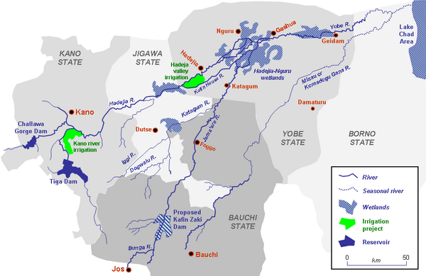
The Jama’are River, known as the Bunga River in its upper reaches, is a significant waterway in northern Nigeria. It originates from the highlands near Jos, Plateau State, and flows through Bauchi and Yobe states before merging with the Hadejia River to form the Yobe River. This river plays a crucial role in the ecology, agriculture, and livelihoods of communities along its course. However, plans to construct the Kafin Zaki Dam on the river have sparked debate, raising concerns over potential environmental impacts, including changes to seasonal flooding patterns and the local water table.
Geographical Significance
The Jama’are River’s source lies in the highlands near Jos, a region known for its elevated terrain and relatively cooler climate compared to the surrounding lowland areas. The river flows northeast, passing through different terrains and ecosystems, each contributing to the river’s role as a lifeline for local populations.
Upper Reaches: The Bunga River
In its early stages, the river is referred to as the Bunga River. The upper reaches of the river are vital for feeding agricultural lands, supporting biodiversity, and providing freshwater resources for the communities in Plateau and Bauchi states.
Flow through Bauchi and Yobe States
As the river progresses, it enters Bauchi State, where it plays a pivotal role in local agriculture, particularly in irrigation. It also serves as a critical water source for domestic and industrial use. In Yobe State, the river continues its journey until it meets the Hadejia River, forming the Yobe River, which further travels toward Lake Chad, contributing to this vital but shrinking water body.
The Kafin Zaki Dam Controversy
The proposal to construct the Kafin Zaki Dam on the Jama’are River has been a point of contention. Proponents argue that the dam will help control flooding, provide water for irrigation, and generate electricity, which would benefit the local economy. However, opponents raise environmental concerns, particularly regarding the alteration of the river’s natural flooding cycle, which is essential for replenishing the water table and supporting wetland ecosystems.
Potential Environmental Impacts
One of the most significant concerns surrounding the dam’s construction is the potential disruption to seasonal flooding patterns. Seasonal floods are vital for sustaining wetlands and replenishing groundwater reserves, both of which are critical for agriculture and local wildlife. Altering these natural cycles could have long-term consequences for the environment, potentially leading to reduced agricultural productivity and loss of biodiversity.
Climate and Weather Patterns in Jama’are
Jama’are, a town in Bauchi State, located along the river, experiences a tropical savanna climate, which is characterized by distinct wet and dry seasons. This climate type is typical of northern Nigeria and plays a crucial role in the region’s agriculture and water resource management.
Temperature
The average annual temperature in Jama’are is approximately 30.37°C (86.67°F), slightly higher than Nigeria’s national average. The town’s relatively high temperatures, coupled with seasonal variations, have a significant impact on farming practices and water usage.
Precipitation
Jama’are receives an average annual rainfall of 90.02 millimeters (3.54 inches), spread over approximately 121 days of rain, accounting for about 33% of the year. This rainfall is critical for agriculture, as the region depends heavily on rain-fed farming. However, the distribution of rainfall can be uneven, leading to challenges in water management, especially during prolonged dry periods.
Implications of Climate on the Jama’are River
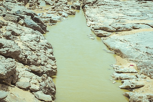
The climate in the Jama’are region directly affects the river’s flow. During the rainy season, the river swells with water, providing much-needed resources for farming and local communities. However, during the dry season, the river’s flow diminishes significantly, sometimes reducing to a trickle. This seasonal variability has made the construction of dams like Kafin Zaki attractive to policymakers, as they offer the potential to regulate water flow and provide a consistent water supply throughout the year.
The Importance of the Jama’are River for Agriculture
The Jama’are River is a vital source of irrigation for farmlands in Bauchi and Yobe states. Many communities depend on the river to irrigate crops such as rice, millet, and sorghum, which are staples in the region. The river’s waters are also used for livestock watering, further emphasizing its importance in sustaining rural livelihoods.
Irrigation Systems
Traditional irrigation methods along the riverbanks involve manual or animal-powered water lifting systems. However, there has been a gradual shift toward more modern irrigation techniques, including pumps and sprinkler systems, particularly in areas where agricultural development projects have been implemented.
Biodiversity and Ecosystem Services
The Jama’are River supports a diverse range of plant and animal species, particularly in its wetlands and floodplains. These ecosystems provide critical services, such as water purification, carbon sequestration, and habitat for fish and other wildlife.
Wetlands
The wetlands along the river are particularly important for bird species, many of which are migratory. These areas also serve as breeding grounds for fish and amphibians, contributing to the region’s biodiversity.
Impact of Human Activities
Human activities, including agriculture, fishing, and dam construction, have placed increasing pressure on the river’s ecosystems. Over fishing, deforestation, and pollution from agricultural runoff are some of the key threats to the river’s health.
The Role of the River in Local Culture
The Jama’are River holds cultural significance for many of the communities living along its banks. It is often seen as a source of life and prosperity, and local folklore and traditions frequently reference the river.
Festivals and Traditions
In some areas, festivals are held to celebrate the river’s importance, particularly during the rainy season when the river is at its fullest. These celebrations often include traditional music, dance, and communal activities centered around the river.
Conclusion
The Jama’are River, also known as the Bunga River in its upper reaches, is a vital waterway for northern Nigeria. It supports agriculture, provides water for domestic and industrial use, and sustains a range of ecosystems. However, the river’s future is uncertain due to the ongoing debate over the construction of the Kafin Zaki Dam and the impact of climate change. Ensuring the sustainable management of the Jama’are River is crucial for the long-term well-being of the communities and ecosystems that depend on it.
Frequently Asked Questions (FAQs)
What is the Jama’are River known for?
The Jama’are River is known for its role in agriculture, irrigation, and providing water for domestic and industrial use in northern Nigeria.
Why is there controversy over the Kafin Zaki Dam?
The Kafin Zaki Dam has sparked controversy due to concerns about its impact on seasonal flooding, the water table, and local ecosystems.
How does the climate affect the Jama’are River?
The river’s flow is heavily influenced by the region’s tropical savanna climate, with significant variations between the wet and dry seasons.
What crops are commonly grown along the Jama’are River?
Common crops grown along the river include rice, millet, and sorghum, which rely on the river’s waters for irrigation.
How does the Jama’are River contribute to local biodiversity?
The river supports wetlands and floodplains that provide habitats for a wide range of plant and animal species, including migratory birds and fish.
What are the potential environmental impacts of building the Kafin Zaki Dam?
Potential environmental impacts include disruption to seasonal flooding, reduced groundwater replenishment, and loss of biodiversity in wetlands.
Cross River CreatedOriginally created in 1967 as South-Eastern State NameCross River is named after the River Cross or the River Oyono in…
Cross River Local Government Areas Cross River has 18 Local Government Areas AbiAkamkpaAkpabuyoBakassiBekwarraBiaseBokiCalabar MunicipalCalabar SouthEtungIkomObanlikuObubraObuduOdukpaniOgojaYakurrYala
List of Local Government Areas in Cross River State and their headquarters Local Government Areas in Cross River State and their headquarters, administrative capitals LGAHeadquartersAbiItigidiAkamkpaAkamkpaAkpabuyoIkot-NakandaBakassiAbanaBekwarraAbuochicieBiaseAkpet-CentralBokiBojeCalabar-MunicipalCalabarCalabar SouthAnantighaEtungEffrayaIkomIkomObubraObubraOgojaOgojaObanlikuSankwalaOdukpaniOdukpaniObuduObuduYakurrUgepYalaOkpoma Local Government Areas Nigeria comprises 774 Local Government…
LGA in Cross River State The LGAs (Local Government Areas) in Cross River State, Nigeria are: Abi Akamkpa Akpabuyo Bakassi Bekwara Biase Boki Calabar Municipal…
SOURCES OF URASHI RIVER Located in Ezeama community in Dikenafai in Ideato-south LGA, this is a spring which has mysterious source from a rope-like…
Cross River State, Nigeria Cross River is a State in southeastern Nigeria. It is known as “The People’s Paradise”. The state has beautiful natural…
Past Governors of Cross River State Cross River State has witnessed evolution of leadership from military to civilian rule, with each governor contributing to the State’s…
Cross River Governors Paul Omu (Administrator – Military): February 1976 – July 1978 Babatunde Elegbede (Administrator – Military): July 1978 – October 1979…
Cross River State Senatorial Districts Cross River state have three (3) Senatorial Zones Districts. They are Cross River Central Senatorial District, Cross River North Senatorial…
Festivals in Cross River, Nigeria Festivals in Cross River state includes: The Cross River State Christmas Festival – 1 December to 31 December annually The…
History of Cross River State Creation Cross River State, situated in the South-South geopolitical zone, was created on May 27, 1967, as a result of…
CROSS RIVER NATIONAL PARK The Cross River National Park is a prominent park in Cross River State, Nigeria. Animal species found in both sectors…
Cross River State, Nigeria Cross River, a state in southern Nigeria, close to the Atlantic ocean to the South and Cameroon to the East.…