Municipal District El Pari: Identity, Territory, and Growth
Municipal District El Pari is a district deeply rooted in history and community identity. Founded in 1957, this district carries a name that honors one of the most significant historical events of the region—the Battle of El Pari, fought during the Santa Cruz wars of independence. This legacy gives the district a symbolic and cultural importance that goes beyond administrative boundaries.
With an approximate population of 80,000 inhabitants, well-defined neighborhoods, and a strategic urban location, Municipal District El Pari plays a vital role in the city’s western-central development. This article offers a comprehensive review of its history, geography, population, and neighborhood structure.
Historical Foundation and Origin of the Name
Foundation Year and Anniversary
Municipal District El Pari was officially founded in 1957, marking a key moment in the city’s administrative expansion. Its anniversary is celebrated every September 7th, a date that reinforces the district’s strong connection to historical memory.
Historical Significance of the Name
The district’s name pays tribute to the Battle of El Pari, a decisive confrontation during the Santa Cruz wars of independence. By adopting this name, the district preserves an important chapter of regional history and keeps alive the values of resistance, identity, and freedom.
Geographic Location and Urban Boundaries
Strategic Urban Position
Municipal District El Pari is located within a well-connected urban zone that allows easy access to surrounding districts and major avenues.
Defined Territorial Limits
The district extends:
From the second to the fourth ring road
Between Piraí Avenue and La Barranca Avenue
These boundaries provide clear jurisdictional definition and support efficient transportation and urban planning.
Territorial Extension and Land Area
Surface Area
Municipal District El Pari covers approximately 1,074 hectares, offering ample space for residential neighborhoods, community infrastructure, and public services.
The district’s land area allows for:
Organized neighborhood distribution
Balanced population density
Sustainable urban growth
Population and Demographic Overview
Population Statistics
According to the 2012 Census, the district has a population of approximately 74,000 inhabitants, while current estimates place the population closer to 80,000 residents.
Population Characteristics
This population size reflects a mature residential district with:
Established families
Active community life
Ongoing urban consolidation
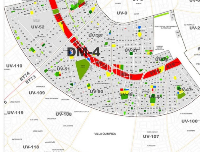
Administrative Organization and Neighborhood Structure
Residential and Neighborhood Units
Municipal District El Pari is organized into:
10 residential (neighborhood) units
19 officially recognized neighborhoods
This administrative structure supports effective governance, planning, and service delivery.
Main Neighborhoods of Municipal District El Pari
Prominent and Well-Known Neighborhoods
The district includes several neighborhoods recognized for their size, location, and community influence. The main neighborhoods include:
El Pari
Fátima
La Morita
Guaracal
Alto San Pedro
Militar
Braniff
Ramafa
Urbarí (residential area)
La Palmas (residential area)
These neighborhoods form the social and cultural backbone of the district.
Residential Life and Urban Character
Housing and Community Layout
Municipal District El Pari is primarily residential, featuring:
Traditional neighborhoods
Established residential zones
Community-oriented urban design
This layout fosters neighborhood cohesion and long-term residency.
Quality of Life
The district offers a balanced urban environment with accessible roads, proximity to major avenues, and a strong sense of local identity.
Transportation and Connectivity
Road Access and Mobility
Being located between two major ring roads and bordered by key avenues, the district benefits from:
Efficient vehicle circulation
Public transportation accessibility
Direct connections to other city sectors
Public Infrastructure and Municipal Services
Service Coverage
The district’s defined residential units allow municipal authorities to plan and deliver:
Public utilities
Community services
Infrastructure improvements
This organized approach supports consistent urban functionality.
Cultural Identity and Historical Memory
Preserving Historical Significance
The name and anniversary of Municipal District El Pari reinforce its role as a guardian of historical memory within the city.
Community Pride
Residents often identify strongly with the district’s historical roots, contributing to civic pride and community engagement.
Urban Importance Within the City
Role in City Development
Municipal District El Pari serves as an important residential and cultural district, supporting the city’s population growth and social stability.
Its location and population density make it a key area for:
Urban planning initiatives
Infrastructure investment
Community development programs
Future Outlook and Development Potential
Sustainable Urban Growth
With its established neighborhoods and strategic location, the district is well-positioned for sustainable improvements without compromising its historical identity.
Balancing History and Modernization
Future development efforts will focus on maintaining the district’s heritage while improving services and mobility.
FAQs About Municipal District El Pari
1. When was Municipal District El Pari founded?
It was founded in 1957.
2. What is the anniversary date of the district?
Its anniversary is celebrated on September 7th.
3. Why is it called El Pari?
The name honors the Battle of El Pari, fought during the Santa Cruz wars of independence.
4. How many people live in the district?
It has approximately 74,000 inhabitants according to the 2012 Census, with estimates nearing 80,000 residents.
5. How large is the district?
It covers 1,074 hectares.
6. How many neighborhoods does it include?
Municipal District El Pari includes 19 neighborhoods organized into 10 residential units.
Municipal District El Pari is a district where history and urban life intersect. Founded in 1957 and named in honor of a pivotal independence battle, it stands as a symbol of identity, resilience, and community strength. With its organized neighborhoods, strategic location, and growing population, the district continues to play a vital role in the city’s development.
Its balance between historical legacy and modern urban living ensures that Municipal District El Pari remains an essential and respected part of the municipality—both today and in the years ahead.
LGA in Abuja, Federal Capital Territory (FCT) The LGAs (Local Government Areas) in Abuja, Federal Capital Territory (FCT), Nigeria are: Abaji Abuja Municipal Area Council Bwari Gwagwalada…
OR TAMBO DISTRICT O.R. Tambo District Municipality is situated along the eastern side of the Eastern Cape Province. It is regarded as one…
Largest areas by population in Chemba District Council, Tanzania 10 most populated areas in Chemba District Council, Tanzania are: MrijoJangaloLahodaDalaiKwamtoroParangaKidokaSanzawaFarkwaGoima LARGE. List of areas by population in Chemba District Council…


 and their headquarters")
")


 in UK, the locations and procedure")


