Full list of Nigeria states land size. From largest to smallest
State
Area (Km²)
Borno
72,767
Niger
72,065
Taraba
59,180
Bauchi
48,197
Yobe
44,880
Kaduna
44,217
Adamawa
37,957
Kebbi
36,320
Kwara
33,792
Zamfara
33,667
Sokoto
32,146
Benue
30,755
Kogi
29,063
Oyo
27,036
Nasarawa
26,633
Plateau
26,539
Katsina
23,822
Jigawa
23,415
Cross River
22,112
Kano
20,389
Edo
19,584
Gombe
17,428
Delta
17,095
Ogun
16,850
Ondo
15,019
Rivers
10,361
Bayelsa
9,363
Osun
8,585
Federal Capital Territory, Abuja
7,569
Enugu
7,560
Akwa Ibom
6,788
Ebonyi
6,342
Ekiti
5,797
Imo
5,135
Abia
4,857
Anambra
4,761
Lagos
3,475
Total
911,519
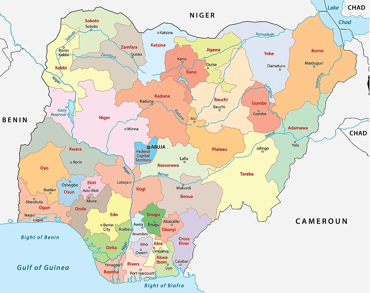
Map of Nigeria’s 36 states & Abuja (the Federal Capital Territory)
States creation, reformation
By the time that Nigeria got independence it was a federation of the three regions, namely:
Western Eastern Northern
Later on another region was added, the Mid-Western Region.
The Mid-Western Region was formed from the Western Region in 1966, and Lagos, the capital, was effectively governed as an unofficial fourth region outside the bounds of the Western Region.
This brought the number of regions to 4 as follows:
Western Mid-Western Western Northern
Under the short-lived military government of Aguiyi-Ironsi, Nigeria was reorganized under a central government. Following a coup which resulted in Aguiyi-Ironsi’s deposition and assassination, Nigeria was reorganized as a federal country again with three of the regions being divided into newer entities and all first-level subdivisions being renamed as states.
Western Region was divided into: Lagos and Western states.
Eastern Region was divided into: East-Central, Rivers, and South-Eastern states;
Northern Region was divided into: Benue-Plateau, Kano, Kwara, North-Central, North-Eastern, and North-Western (Sokoto) states
1976 reformation of Nigeria’s federating units
In 1976, six years after the end of the civil war, the states were further reorganized:
State boundaries and names were also reorganized.
Benue-Plateau state divided into: Benue and Plateau states.
East-Central state divided into: Anambra and Imo states. Federal Capital Territory (Abuja) formed from parts of Niger and Plateau states.
North-Eastern state divided into: Bauchi, Borno, and Gongola states. Niger (Minna) state split from Sokoto.
Western state divided into: Ogun, Ondo, and Oyo states
States of Nigeria from 1987-1991
Akwa Ibom state created from Cross River; Katsina state created from Kaduna
States of Nigeria from 1991-1996
Abia State created from Imo; Bendel State divided into Delta and Edo; Enugu State created from Anambra; Gongola State divided into Adamawa and Taraba; Jigawa State created from Kano; Kebbi State created from Sokoto; Kogi State formed from parts of Benue and Kwara; Osun State created from Oyo; Yobe State created from Borno.
States of Nigeria from 1996
Bayelsa State created from Rivers; Ebonyi State was formed from parts of Abia and Enugu; Ekiti State created from Ondo; Gombe State created from Bauchi; Nasarawa State created from Plateau; Zamfara State was created from Sokoto.
Biggest local government area in Nigeria Borgu Local Government Area, in Niger State, is Nigeria’s largest local government area by land size with 11,267 km2. The…
Biggest states in Nigeria by population Nigeria’s top 10 biggest states by population are: KanoLagosKadunaKatsinaOyoRiversBauchiJigawaBenueAnambra Population size of Nigeria states. From largest to smallest Based on…
Biggest tomato company in Africa The launch of Africa’s largest tomato processing plant by Dangote Group in Kadawa, Kano State, is a significant development for…
Biggest airport in Botswana The biggest airport in Botswana is Sir Seretse Khama International Airport with IATA code: GBE Sir Seretse Khama International Airport…
Nigeria states and capitals, population, land area States of Nigeria; their capitals, population, land and area in Km² StateCapitalPopulationArea (Km²)AbiaUmuahia2,833,9994,857AdamawaYola3,168,10137,957Akwa IbomUyo3,920,2086,788AnambraAwka4,182,0324,761BauchiBauchi4,676,46548,197BayelsaYenagoa1,703,3589,363BenueMakurdi4,219,24430,755BornoMaiduguri4,151,19372,767Cross RiverCalabar2,888,96622,112DeltaAsaba4,098,39117,095EbonyiAbakaliki2,173,5016,342EdoBenin City3,218,33219,584EkitiAdo-Ekiti2,384,2125,797EnuguEnugu3,257,2987,560Federal Capital TerritoryAbuja1,405,2017,569GombeGombe2,353,87917,428ImoOwerri3,934,8995,135JigawaDutse4,348,64923,415KadunaKaduna6,066,56244,217KanoKano9,383,68220,389KatsinaKatsina5,792,57823,822KebbiBirnin Kebbi3,238,62836,320KogiLokoja3,278,48729,063KwaraIlorin2,371,08933,792LagosIkeja9,013,5343,475NasarawaLafia1,863,27526,633NigerMinna3,950,24972,065OgunAbeokuta3,728,09816,850OndoAkure3,441,02415,019OsunOshogbo3,423,5358,585OyoIbadan5,591,58927,036PlateauJos3,178,71226,539RiversPort Harcourt5,185,40010,361SokotoSokoto3,696,99932,146TarabaJalingo2,300,73659,180YobeDamaturu2,321,59144,880ZamfaraGusau3,259,84633,667Total140,003,542911,519…
10 smallest states of Nigeria by land area The 10 smallest states of Nigeria by land area are: LagosAnambraAbiaImoEkitiEbonyiAkwa IbomEnuguFederal Capital TerritoryOsun Full list of Nigeria states by…
10 largest states of Nigeria by land area The 10 largest states of Nigeria by land area are: BornoNigerTarabaBauchiYobeKadunaAdamawaKebbiKwaraZamfara Full list of Nigeria states land size. From largest…


, State Capitals, Land Area, Population, GDP, Subdivisions (Districts, Cities and Municipalities)")
