The Hadejia River: A Vital Waterway in Northern Nigeria
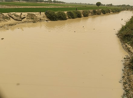
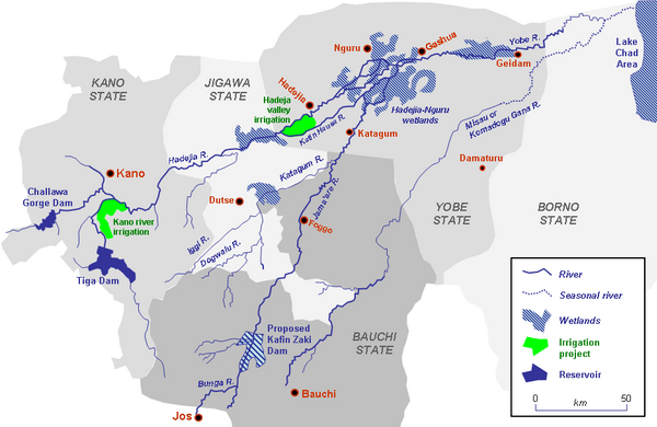
The Hadejia River (Hausa: Kogin Haɗeja) is a significant river in Northern Nigeria, serving as one of the main tributaries of the Yobe River (also known as the Komadugu Yobe). Originating from Kano State, the river flows through several cities and towns, including Hadejia and Nguru, where it plays a critical role in supporting the livelihoods of the local populations. Along with Nguru Lake, the Hadejia River forms the valuable Hadejia-Nguru wetlands, a biodiversity hotspot and a crucial resource for agriculture and fishing.
However, human interventions—such as the construction of dams for irrigation and flood control—have significantly affected the river’s flow and the ecological balance of the surrounding wetlands. Additionally, the Hadejia River is central to the region’s flood risk management, given its history of seasonal flooding. This article provides a comprehensive overview of the river, its geography, climate, ecological importance, and challenges, including the impact of dams and flooding.
Geography and Course of the Hadejia River
The Hadejia River is part of the extensive river network in northern Nigeria. It is a major tributary of the Yobe River, which flows eastward and eventually feeds into Lake Chad, a key water body that supports millions of people across Nigeria, Niger, Chad, and Cameroon.
Cities and Towns Along the River
The river flows through important cities, including Hadejia and Nguru, in Jigawa State. These towns rely on the river for irrigation, fishing, and domestic use. The river’s floodplains have historically been vital for agricultural activities, particularly in rice and millet cultivation.
Hadejia: This town is one of the largest settlements along the river and has been an important center for commerce and agriculture for centuries.
Nguru: Situated further downstream, Nguru is another significant town that benefits from the river, especially in terms of fishing and wetland agriculture.
The Hadejia-Nguru Wetlands: An Ecological Gem
The Hadejia-Nguru wetlands, formed by the interaction of the Hadejia River and Nguru Lake, are one of Nigeria’s most ecologically important regions. These wetlands provide a habitat for a diverse range of flora and fauna, including migratory birds, fish species, and aquatic plants.
Biodiversity and Conservation
The wetlands are an internationally recognized Important Bird Area (IBA) and are home to numerous migratory birds, particularly during the dry season. The area supports diverse species, including the black-crowned crane (Balearica pavonina) and the West African manatee (Trichechus senegalensis). The wetlands also support a thriving fishing community, with numerous fish species being harvested by local fishers.
However, the wetlands are under severe threat due to changes in the river’s flow, primarily caused by damming and reduced water levels.
Impact of Damming on the Hadejia River
One of the most significant changes to the Hadejia River in recent years has been the construction of dams, particularly the Tiga Dam and the Challawa Gorge Dam, both located upstream in Kano State. These dams were primarily built to support irrigation and water supply for Kano’s expanding agricultural and urban areas.
Effects on the Hadejia-Nguru Wetlands
The dams have reduced the flow of water downstream, contributing to the shrinking of the Hadejia-Nguru wetlands. According to reports, the river is now 80% controlled by the Tiga and Challawa Gorge dams, drastically altering its natural hydrology. The reduced flow has led to a decline in wetland size, affecting biodiversity and the livelihoods of people who depend on the wetlands for fishing, farming, and livestock rearing.
Irrigation and Agriculture
While the dams have enabled the expansion of irrigated agriculture in Kano State, especially for crops like rice, vegetables, and sugarcane, they have reduced the availability of water for downstream users in Jigawa and Yobe states. This has led to conflicts between water users and concerns over water allocation among states sharing the river basin.
Flood Management in the Hadejia River Basin
The Hadejia River has a long history of seasonal flooding, which has both positive and negative impacts on the region. While floods help recharge the wetlands and support agricultural activities, they can also cause damage to homes, infrastructure, and farmlands.
Flooding and Flood Control Efforts
In recent years, flooding has become a more pressing issue due to climate change and upstream water management. In response, the Jigawa State government has undertaken projects to clear the Hadejia River’s canal to prevent future flooding and control water overflows. This work has become particularly urgent following significant flooding events that have caused displacement and property damage in towns like Hadejia.
Flood Frequency Analysis
A flood frequency analysis of the Hadejia River was conducted using maximum annual streamflow data from 1963 to 2014. Three probability distribution models—Extreme Value Type 1 (EV-1), Lognormal (LN), and Log Pearson Type III (LP III)—were used to predict flood discharge for return periods of 2 to 200 years. The study found that the Lognormal distribution provided the most accurate flood discharge estimates for long-term flood management planning.
For a 200-year return period, the predicted discharge values for the models were as follows:
EV-1: 157.419 m³/s
Lognormal: 169.43 m³/s
LP III: 135.21 m³/s
These predictions help policymakers and engineers in designing infrastructure that can withstand extreme flood events, ensuring the safety of communities along the river.
Climate and Weather Patterns in Hadejia
Hadejia experiences a typical tropical savanna climate with distinct wet and dry seasons. The wet season brings high temperatures and frequent cloud cover, while the dry season is characterized by clear skies and lower humidity.
Temperature and Seasonal Variations
Wet Season: The wet season, lasting from March to June, is characterized by hot temperatures with highs reaching over 101°F. May is typically the hottest month of the year, with an average high of 103°F and lows around 80°F.
Dry Season: The dry season, which lasts from December to January, sees cooler temperatures, with daily highs below 90°F. January is the coldest month, with average temperatures ranging between 59°F at night and 88°F during the day.
These temperature variations influence agricultural cycles, water demand, and the overall hydrology of the river basin.
Conclusion
The Hadejia River is an integral part of Northern Nigeria’s water system, supporting agriculture, biodiversity, and local economies. However, human interventions—such as damming for irrigation—have significantly altered the river’s flow, contributing to the degradation of the Hadejia-Nguru wetlands. Additionally, the river’s propensity for seasonal flooding requires ongoing management to prevent disasters while preserving the ecological benefits of natural flood cycles.
Sustainable management of the Hadejia River is crucial for the long-term well-being of the people and ecosystems that depend on it. This will require a balance between agricultural expansion, water conservation, and flood control, with greater emphasis on protecting the unique wetlands that have historically thrived along its banks.
Frequently Asked Questions (FAQs)
What is the significance of the Hadejia River?
The Hadejia River is a major tributary of the Yobe River and plays a vital role in supporting agriculture, biodiversity, and local livelihoods in northern Nigeria. It also forms part of the Hadejia-Nguru wetlands, an important ecological region.
How have dams affected the Hadejia River?
The construction of the Tiga and Challawa Gorge dams has reduced the river’s flow downstream, affecting the Hadejia-Nguru wetlands and causing water shortages for agriculture and domestic use.
What are the Hadejia-Nguru wetlands?
The Hadejia-Nguru wetlands are an ecologically important area formed by the Hadejia River and Nguru Lake. They provide habitats for migratory birds and support local fisheries and agriculture.
Why is flood management important along the Hadejia River?
Flood management is critical to prevent damage to communities and infrastructure, as the river is prone to seasonal flooding. Efforts are underway to clear canals and reduce flood risks.
What are the main climate characteristics of the Hadejia region?
The Hadejia region has a tropical savanna climate, with a hot wet season from March to June and a cooler dry season from December to January. Temperatures can range from 59°F to 105°F throughout the year.
What methods are used to predict flooding on the Hadejia River?
Flood frequency analysis uses models like Extreme Value Type 1 (EV-1), Lognormal (LN), and Log Pearson Type III (LP III) to predict flood discharge for different return periods, helping in flood management planning.
Nile: The world’s longest river The Nile River, renowned as the longest river in the world, spans an impressive 6,853 kilometers (4,258 miles), traversing northeastern…
Where four countries meet Zambezi River Kazungula is the place where four countries meet Zambezi River In the northern part of Botswana, four countries (Zambia, Botswana,…
SOURCE OF RIVER ETHIOPE River Ethiope, said to be the deepest inland waterway in Africa, has its source at the foot of a giant…
ABRAKA RIVER RESORT MOTEL Located in the university town of Abraka in Ethiope East Local Government Area, Abraka River Resort Motel is ideal for…
Cross River Paramount Traditional Rulers The top traditional rulers in Cross River State, Nigeria are: HRH (His Royal Highness) Eval Lawrence Idaka Egbe HRH Echi…
Cross River Festivals Festivals in Cross River bring in tourists from far and wide into the state to enjoy themselves and also do…