The administrative divisions of Brunei, including districts, municipalities mukims and villages. How Brunei’s governance is structured and how its population is organized.
Brunei Darussalam, a small but strategically significant nation on the island of Borneo, is not only known for its wealth and natural resources but also for its well-organized administrative structure. Understanding the administrative divisions of Brunei is essential for anyone looking into the country’s governance, socio-political organization, or even planning a visit. This system is hierarchical, efficient, and serves as the backbone for population management, local administration, and government oversight.
In Brunei, the administrative framework is divided primarily into districts (daerah), sub-districts (mukim), and villages (kampong or kampung), with municipalities and towns forming a separate but essential layer of urban governance.
Overview of Brunei’s Administrative Structure
Brunei’s administrative hierarchy is designed to centralize governance while still allowing for local administrative management. All divisions fall under the Ministry of Home Affairs, with limited autonomy at the lowest levels. Major policy areas like education, law, and national infrastructure remain centrally controlled.
The divisions are mainly organized as follows:
Districts (Daerah) – Largest units, headed by a District Officer.
Mukims (Sub-Districts) – Intermediate divisions, led by a penghulu.
Villages (Kampong) – Smallest administrative units, led by a ketua kampong.
Municipalities and Towns – Administered separately but serve as focal points of population and economic activity.
This structure ensures that census-taking, local governance, and development planning are managed efficiently across the country.
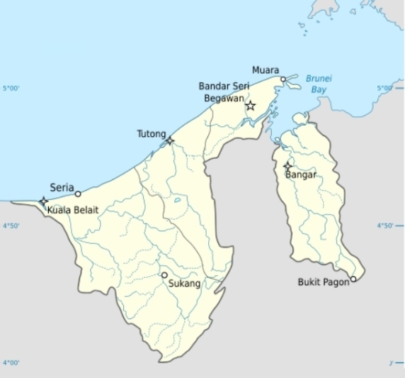
Districts of Brunei
Brunei is divided into four districts, each with unique characteristics:
District
Area Size
Population
Key Features
Brunei-Muara
Smallest
Largest population
Capital city Bandar Seri Begawan; economic and administrative hub
Belait
Largest
Moderate
Oil and gas production center; industrial development
Tutong
Medium
Moderate
Known for natural reserves and cultural villages
Temburong
Small
Smallest
Isolated, rich in rainforests and eco-tourism
Each district is administered by a Pegawai Daerah (District Officer) supported by an assistant. Brunei-Muara, despite its small size, houses the majority of the population, making it the most politically and economically significant district. Belait, on the other hand, is Brunei’s energy hub, responsible for most of the nation’s oil and gas output.
Mukims: Sub-Districts of Brunei
Below the district level are mukims, which are smaller administrative areas designed to facilitate local governance. There are 38 mukims across Brunei:
District
Number of Mukims
Brunei-Muara
17
Tutong
8
Belait
8
Temburong
5
Each mukim is headed by a penghulu, who acts as the liaison between the villages and the district administration. The mukim system ensures that governance and public services reach smaller population centers effectively.
Villages (Kampong): The Grassroots Level
At the base of Brunei’s administrative pyramid are villages (kampong or kampung). These units are crucial for community organization, local planning, and census operations. A village may have anywhere from a few hundred to several thousand residents. Each village is headed by a ketua kampong (village head).
One notable example is Kampong Ayer, often referred to as the “Venice of the East.” While it is not officially classified as a single village, it consists of several mukims and numerous kampongs along the Brunei River. This water village reflects Brunei’s unique cultural and historical heritage.
Municipalities and Towns
While districts, mukims, and villages follow a strict hierarchy, municipalities in Brunei are administered outside this framework. The major municipalities include:
Bandar Seri Begawan – Capital city and economic hub.
Kuala Belait – Administrative center for Belait District.
Seria – Oil-rich town in Belait District.
Tutong Town – Administrative center for Tutong District.
Municipalities are governed by a Pengerusi Lembaga Bandaran (Town Board Chairman) and may cover multiple mukims or only a few villages. Some towns, such as Bangar and Muara, retain the administrative status of villages despite their urban significance.
Population Census: Accurate tracking of demographic data.
Local Governance: Efficient delivery of services through mukims and villages.
Urban Planning: Municipality management ensures sustainable growth in key towns.
Resource Management: Districts like Belait centralize economic activities such as oil production.
By organizing governance hierarchically, Brunei ensures that even its smallest communities are represented in the national administration.
FAQs About Brunei’s Administrative Divisions
1. How many districts does Brunei have? Brunei has four districts: Brunei-Muara, Belait, Tutong, and Temburong.
2. What is a mukim? A mukim is a sub-district level administrative division in Brunei, headed by a penghulu.
3. Who governs a village in Brunei? A village is managed by a ketua kampong or village head.
4. Are municipalities part of the district hierarchy? No, municipalities are administered separately but still fall under the Ministry of Home Affairs.
5. Which is the largest district in Brunei? Belait is the largest district by area and the center of oil and gas production.
6. What is Kampong Ayer? Kampong Ayer is a cluster of water villages along the Brunei River and is not an official administrative division.
The administrative divisions of Brunei reflect a balance between centralized governance and local management. From the four districts to the intricate network of mukims and villages, the structure allows Brunei to manage its population, resources, and urban development efficiently. Municipalities provide urban centers that operate alongside this hierarchy, ensuring both rural and urban areas thrive under a unified governance system.
More
List of Mukims in Brunei A mukim is the second-level administrative division of Brunei Darussalam, positioned below districts (daerah) and above villages (kampung). Each mukim…
List of Brunei Municipalities In Brunei Darussalam, municipalities are officially incorporated urban settlements administered directly by municipal departments under the Ministry of Home Affairs.…


")


")


