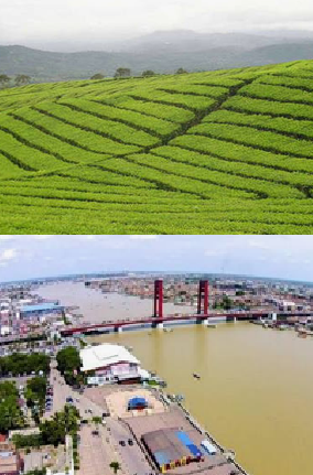
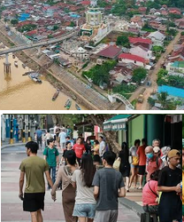
Districts of South Sumatra, Indonesia: Administrative Divisions, Key Details
South Sumatra (Sumatera Selatan) is a province in the southern part of the Indonesian island of Sumatra. It is one of the country’s important administrative, economic, agricultural and natural-resource regions, with a provincial capital in Palembang.
The province is divided into regencies (kabupaten) and autonomous cities (kota), which are further subdivided into districts known as kecamatan. These districts form the third level of Indonesia’s administrative structure and are responsible for coordinating local government services, development programmes and administration.
According to the Badan Pusat Statistik (BPS), Indonesia’s national statistics agency, South Sumatra had 241 districts across 17 regencies and cities in 2025. These comprised 13 regencies and four autonomous cities. The province also had 3,285 villages and urban wards (desa/kelurahan). Badan Pusat Statistik Provinsi Sumatera Selatan+2
1. Administrative structure of South Sumatra
South Sumatra has the following 17 second-level administrative divisions:
13 regencies (kabupaten).
Four autonomous cities (kota).
241 districts (kecamatan).
No.
Regency or city
Number of districts
1
Ogan Komering Ulu
13
2
Ogan Komering Ilir
18
3
Muara Enim
22
4
Lahat
24
5
Musi Rawas
14
6
Musi Banyuasin
15
7
Banyuasin
21
8
Ogan Komering Ulu Selatan
19
9
Ogan Komering Ulu Timur
20
10
Ogan Ilir
16
11
Empat Lawang
10
12
Penukal Abab Lematang Ilir
5
13
Musi Rawas Utara
7
14
Palembang City
18
15
Prabumulih City
6
16
Pagar Alam City
5
17
Lubuklinggau City
8
Total
241
Source: BPS South Sumatra, 2025 administrative statistics. Badan Pusat Statistik Provinsi Sumatera Selatan+1
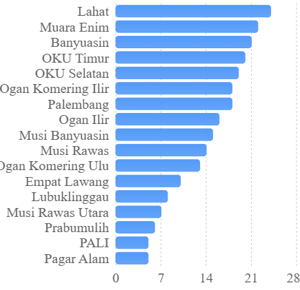
Lahat has the highest number of districts, with 24, followed by Muara Enim with 22 and Banyuasin with 21. Pagar Alam has the lowest number among the autonomous cities, with five districts.
2. Numbered list of districts and their regencies
A. Ogan Komering Ulu Regency
Baturaja Barat — Ogan Komering Ulu.
Baturaja Timur — Ogan Komering Ulu.
Lengkiti — Ogan Komering Ulu.
Lubuk Batang — Ogan Komering Ulu.
Pengandonan — Ogan Komering Ulu.
Peninjauan — Ogan Komering Ulu.
Semidang Aji — Ogan Komering Ulu.
Sosoh Buay Rayap — Ogan Komering Ulu.
Ulu Ogan — Ogan Komering Ulu.
B. Ogan Komering Ilir Regency
Air Sugihan — Ogan Komering Ilir.
Cengal — Ogan Komering Ilir.
Jejawi — Ogan Komering Ilir.
Kota Kayu Agung — Ogan Komering Ilir.
Lempuing Jaya — Ogan Komering Ilir.
Mesuji — Ogan Komering Ilir.
Pampangan — Ogan Komering Ilir.
Pedamaran — Ogan Komering Ilir.
Pematang Panggang — Ogan Komering Ilir.
Sirah Pulau Padang — Ogan Komering Ilir.
Tanjung Lubuk — Ogan Komering Ilir.
Tulung Selapan — Ogan Komering Ilir.
C. Muara Enim Regency
Benakat — Muara Enim.
Gelumbang — Muara Enim.
Gunung Megang — Muara Enim.
Kelekar — Muara Enim.
Lawang Kidul — Muara Enim.
Lembak — Muara Enim.
Lubai — Muara Enim.
Muara Belida — Muara Enim.
Muara Enim — Muara Enim.
Penukal Abab — historically listed under Muara Enim; now associated with Penukal Abab Lematang Ilir.
Penukal Utara — historically listed under Muara Enim; now associated with Penukal Abab Lematang Ilir.
Penukal — historically listed under Muara Enim; now associated with Penukal Abab Lematang Ilir.
Rambang Dangku — Muara Enim.
Rambang — Muara Enim.
Semende Darat Laut — Muara Enim.
Semende Darat Tengah — Muara Enim.
Semende Darat Ulu — Muara Enim.
Sungai Rotan — Muara Enim.
Talang Ubi — historically listed under Muara Enim; now associated with Penukal Abab Lematang Ilir.
Tanah Abang — historically listed under Muara Enim; now associated with Penukal Abab Lematang Ilir.
Tanjung Agung — Muara Enim.
Ujan Mas — Muara Enim.
D. Lahat Regency
Jarai — Lahat.
Kikim Barat — Lahat.
Kikim Selatan — Lahat.
Kikim Tengah — Lahat.
Kikim Timur — Lahat.
Kota Agung — Lahat.
Lahat — Lahat.
Lintang Kanan — historically listed under Lahat; administratively associated with Empat Lawang.
Merapi — Lahat.
Muara Pinang — historically listed under Lahat; administratively associated with Empat Lawang.
Mulak Ulu — Lahat.
Pajar Bulan — Lahat.
Pasemah Air Keruh — historically listed under Lahat; administratively associated with Empat Lawang.
Pendopo — historically listed under Lahat; administratively associated with Empat Lawang.
Pulau Pinang — Lahat.
Talang Padang — Lahat.
Tanjung Sakti — Lahat.
Tebing Tinggi — historically listed under Lahat; administratively associated with Empat Lawang.
Ulu Musi — historically listed under Lahat; administratively associated with Empat Lawang.
E. Musi Rawas Regency
BKL Ulu Terawas — Musi Rawas.
BTS Ulu — Musi Rawas.
Jayaloka — Musi Rawas.
Karang Dapo — historically listed under Musi Rawas; check the current regency assignment.
Karang Jaya — historically listed under Musi Rawas; check the current regency assignment.
Muara Beliti — Musi Rawas.
Muara Kelingi — Musi Rawas.
Muara Lakitan — Musi Rawas.
Megang Sakti — Musi Rawas.
Purwodadi — Musi Rawas.
Selangit — Musi Rawas.
Tugumulyo — Musi Rawas.
F. Musi Banyuasin Regency
Babat Toman — Musi Banyuasin.
Batang Harileko — Musi Banyuasin.
Bayung Lencir — Musi Banyuasin.
Keluang — Musi Banyuasin.
Lais — Musi Banyuasin.
Lalan — Musi Banyuasin.
Plakat Tinggi — Musi Banyuasin.
Sanga Desa — Musi Banyuasin.
Sekayu — Musi Banyuasin.
Sungai Keruh — Musi Banyuasin.
Sungai Lilin — Musi Banyuasin.
G. Banyuasin Regency
Banyuasin I — Banyuasin.
Banyuasin II — Banyuasin.
Banyuasin III — Banyuasin.
Betung — Banyuasin.
Makarti Jaya — Banyuasin.
Muara Padang — Banyuasin.
Muara Telang — Banyuasin.
Pulau Rimau — Banyuasin.
Rambutan — Banyuasin.
Rantau Bayur — Banyuasin.
Talang Kelapa — Banyuasin.
H. Ogan Komering Ulu Selatan Regency
Banding Agung — Ogan Komering Ulu Selatan.
Buay Pemaca — Ogan Komering Ulu Selatan.
Buay Runjung — Ogan Komering Ulu Selatan.
Buay Sandang Aji — Ogan Komering Ulu Selatan.
Kisam Tinggi — Ogan Komering Ulu Selatan.
Mekakau Ilir — Ogan Komering Ulu Selatan.
Muaradua Kisam — Ogan Komering Ulu Selatan.
Muaradua — Ogan Komering Ulu Selatan.
Pulau Beringin — Ogan Komering Ulu Selatan.
Simpang — Ogan Komering Ulu Selatan.
I. Ogan Komering Ulu Timur Regency
Belitang II — Ogan Komering Ulu Timur.
Belitang III — Ogan Komering Ulu Timur.
Belitang — Ogan Komering Ulu Timur.
Buay Madang — Ogan Komering Ulu Timur.
Buay Pemuka Peliung — Ogan Komering Ulu Timur.
Cempaka — Ogan Komering Ulu Timur.
Madang Suku I — Ogan Komering Ulu Timur.
Madang Suku II — Ogan Komering Ulu Timur.
Martapura — Ogan Komering Ulu Timur.
Semendawai Suku III — Ogan Komering Ulu Timur.
J. Ogan Ilir Regency
Indralaya — Ogan Ilir.
Muara Kuang — Ogan Ilir.
Pemulutan — Ogan Ilir.
Rantau Alai — Ogan Ilir.
Tanjung Batu — Ogan Ilir.
Tanjung Raja — Ogan Ilir.
K. Empat Lawang Regency
123. Pendopo Lintang — the source’s entry is problematic; it should not be treated as a verified current district name.
L. Penukal Abab Lematang Ilir Regency
124. Abab — Penukal Abab Lematang Ilir.
M. Musi Rawas Utara Regency
Muara Rupit — historically associated with Musi Rawas; now in Musi Rawas Utara.
Nibung — historically associated with Musi Rawas; now in Musi Rawas Utara.
Rawas Ilir — historically associated with Musi Rawas; now in Musi Rawas Utara.
Rawas Ulu — historically associated with Musi Rawas; now in Musi Rawas Utara.
Ulu Rawas — historically associated with Musi Rawas; now in Musi Rawas Utara.
N. Palembang City
Alang-Alang Lebar — Palembang.
Bukit Kecil — Palembang.
Gandus — Palembang.
Ilir Barat I — Palembang.
Ilir Barat II — Palembang.
Ilir Timur I — Palembang.
Ilir Timur II — Palembang.
Kalidoni — Palembang.
Kemuning — Palembang.
Kertapati — Palembang.
Plaju — Palembang.
Sako — Palembang.
Seberang Ulu I — Palembang.
Seberang Ulu II — Palembang.
Sematang Borang — Palembang.
Sukarame — Palembang.
O. Prabumulih City
Cambai — Prabumulih.
Prabumulih Barat — Prabumulih.
Prabumulih Timur — Prabumulih.
Rambang Kapak Tengah — Prabumulih.
P. Pagar Alam City
Dempo Selatan — Pagar Alam.
Dempo Tengah — Pagar Alam.
Dempo Utara — Pagar Alam.
Pagar Alam Selatan — Pagar Alam.
Pagar Alam Utara — Pagar Alam.
Q. Lubuklinggau City
Lubuklinggau Barat I — Lubuklinggau.
Lubuklinggau Barat II — Lubuklinggau.
Lubuklinggau Selatan I — Lubuklinggau.
Lubuklinggau Selatan II — Lubuklinggau.
Lubuklinggau Timur I — Lubuklinggau.
Lubuklinggau Timur II — Lubuklinggau.
Lubuklinggau Utara I — Lubuklinggau.
Lubuklinggau Utara II — Lubuklinggau.
The numbering above is a reference index for the names reproduced from the supplied article, not an official 2025 district register. The article contains additional omissions and naming or affiliation problems; its entries should not be used as proof that South Sumatra has only 162 districts.
3. Key geographical and administrative details
3.1. The distinction between regencies and cities
South Sumatra’s administrative system includes two types of second-level government:
Regencies (kabupaten): Generally cover larger geographical territories, including rural communities, agricultural settlements, plantations, villages and smaller towns.
Autonomous cities (kota): Have independent municipal administrations and generally feature more concentrated urban populations, commercial activity and infrastructure.
The four cities are Palembang, Prabumulih, Pagar Alam and Lubuklinggau. They are administratively separate from surrounding regencies.
3.2. District distribution
The 241 districts are unevenly distributed throughout the province.
Districts by regency and city
Number of kecamatan in each administrative division, 2025. Source: BPS South Sumatra.
Lahat’s 24 districts make it the province’s most subdivided regency by this measure. This reflects its extensive administrative territory and the need to coordinate services across numerous communities.
3.3. Palembang and its urban districts
Palembang is the provincial capital and a major commercial and transportation centre.
Its 18 districts include Alang-Alang Lebar, Bukit Kecil, Gandus, Ilir Barat I, Ilir Barat II, Ilir Timur I, Ilir Timur II, Kalidoni, Kemuning, Kertapati, Plaju, Sako, Seberang Ulu I, Seberang Ulu II, Sematang Borang and Sukarame, among others.
The city’s administrative structure supports the management of residential neighbourhoods, commercial districts, industrial areas, transportation facilities and public infrastructure.
3.4. Important river systems
South Sumatra’s geography is strongly influenced by its river systems, particularly the Musi River and its tributaries.
These waterways have historically supported transportation, agriculture, fishing, trade and settlement development. Many communities developed along riverbanks because waterways provided access to markets and natural resources.
The river systems also influence the geographical distribution of administrative districts, particularly in Banyuasin, Musi Banyuasin and Ogan Komering Ilir.
4. Understanding the administrative districts of South Sumatra
Administrative organisation and local government
The districts of South Sumatra are an important part of Indonesia’s decentralised administrative system. They provide an intermediate level of government between regencies or cities and villages or urban wards.
Each district is administered by a camat, an official responsible for coordinating government activities within the district. The district administration helps implement policies established by the regency or city government and facilitates communication between higher administrative authorities and local communities.
District administrations are particularly important in a geographically extensive province such as South Sumatra, where communities are distributed across urban centres, agricultural settlements, river valleys, plantation areas and remote rural locations.
The 241 districts provide an administrative framework for delivering public services, coordinating development and managing local government responsibilities.
The importance of the regencies
The 13 regencies account for most of South Sumatra’s geographical territory. They include areas with different economic activities, settlement patterns and natural resources.
Ogan Komering Ulu, for example, is associated with the Baturaja area, which serves as an important regional centre. Ogan Komering Ilir has extensive lowland and wetland environments, while Banyuasin is recognised for its river systems, coastal environments and agricultural activities.
Muara Enim is an important natural-resource and energy-producing region. Its economy has historically been associated with coal mining, petroleum, natural gas and plantation agriculture.
Lahat has a combination of agricultural landscapes, mountainous terrain and established settlements. Its 24 districts make it the most administratively subdivided regency in the province.
Musi Banyuasin is another important economic region, particularly because of its petroleum, natural gas, plantation and agricultural resources.
The regencies therefore have different administrative and economic priorities, which influence how their districts are managed.
The role of the four autonomous cities
The four cities have separate administrative structures from the regencies.
Palembang is the provincial capital and the largest urban centre. Its economy includes trade, manufacturing, transportation, services, education and government administration.
Prabumulih is an important urban centre associated with the energy industry, particularly natural gas and petroleum-related activities.
Pagar Alam is situated in the highland region near Mount Dempo. Its economy includes agriculture, coffee cultivation, tourism and other activities associated with its mountainous environment.
Lubuklinggau serves as an important commercial and transportation centre in western South Sumatra. Its location makes it significant for connections between South Sumatra and neighbouring regions.
Each city has its own districts, municipal government and local administrative responsibilities.
Agriculture and rural development
Agriculture remains an important economic activity across South Sumatra. The province has extensive agricultural land used for rice cultivation, rubber, oil palm, coffee and other crops.
District administrations play an important role in supporting agricultural communities through local development coordination, infrastructure planning and the implementation of government programmes.
In rural areas, the district government serves as an administrative link between regency authorities and village administrations.
This arrangement is particularly important in regions where settlements are dispersed and transportation infrastructure is less developed.
Natural resources and industrial development
South Sumatra has considerable natural-resource potential. Coal, petroleum and natural gas have contributed to its economic development and industrial activity.
Muara Enim and Musi Banyuasin are particularly significant in the province’s energy sector. Other areas have developed around agricultural processing, plantation production, trade and transportation.
The distribution of districts helps local authorities manage development programmes, public facilities, land-use planning and environmental administration.
Population and public services
The distribution of districts also has implications for population management and public-service delivery.
According to the provincial government’s 2025 regional administration report, South Sumatra had approximately 9.14 million residents as of 30 June 2025. Palembang was the most populous city, with more than 1.8 million residents. sumselprov.go.id+1
District administrations help coordinate access to education, healthcare, civil registration, transportation and other public services.
The number of districts in each regency or city is one indicator of administrative subdivision, although it does not independently establish population size, economic importance or development levels.
Sources and references
The following sources provide the statistical and administrative background.
1. Wikipedia – List of districts of South Sumatra: List of districts of South Sumatra. Used as the starting reference for district names and their listed administrative affiliations. The article itself carries an unsourced-content warning.
2. Badan Pusat Statistik South Sumatra – Number of Districts by Regency/Municipality, 2025: Official BPS district statistics. Provides the official district totals for all 17 regencies and cities.
3. BPS South Sumatra – Number of Districts and Villages/Urban Wards, 2025: District and village statistics. Provides the province-wide administrative totals.
4. South Sumatra in Figures 2025: BPS annual statistical publication. Provides broader geographical, demographic and economic information.
5. South Sumatra Provincial Government – 2025 Regional Government Administration Report: Provincial government report. Provides information about the province’s administrative structure and population.
6. BPS – Administrative Area Statistics, 2024: 2024 administrative statistics. Provides an additional reference for district and village totals.
Districts of North Sumatra, Indonesia List of districts (kecamatan) of North Sumatra with the regency or city each belongs to. List of North Sumatra Districts…
Gelephu Mindfulness City: Key Details How Gelephu Mindfulness City is redefining sustainable development through mindful prosperity, progressive governance, and investor-friendly policies in Bhutan. Gelephu Mindfulness…
Aliyah to Jerusalem: Key Details Aliyah to Jerusalem Aliyah (עלייה) refers to Jewish immigration to Israel, and Jerusalem is a top destination for many Olim…