Imo State is has abundant natural resources. These include crude oil, lead, zinc, white clay, fine sand, limestone and natural gas in commercial quantities.
Imo State has a number of mineral-based raw materials for industries. Existing factory and crafts industries are classified into seven groups reflecting the types of major activities. These are:
- Manufacturing,
- Agriculture,
- Building and Construction,
- Mining and Quarrying,
- Water, Gas, Electricity,
- Services and
- Others.
There are a total of 11,607 industrial and business establishments in Imo State: 9,274 are in the services/business, 1,858 in the manufacturing sector, 416 in building and construction, 53 in agricultural activity, while three establishments each are in mining and quarrying as well as in water, gas and electricity.
Entrepreneur in the state need a great deal of support to enable them tool-up their factories and energize their productivity engines. In the good old days, the major state-owned industries in Imo are:
- Standard Shoes Company, Owerri, which produced different types of footwear;
- Clay Products, Ezinachi-Okigwe, which produced burnt bricks for all kinds of buildings;
- Sack Hercules, Owerri, which assembled motor-cycles and bicycles;
- Nsu tile Factory, Ehime-Mbano,
- Imo Health Foods Limited, Ubakalo,
- Adapalm Nigeria Limited,
- Imo Modern Poultry Limited, Avutu-Obowo;
- Modern Produce Inspection Laboratory, Owerri, and
- Oguta Motels Limited, Oguta.
Some of these industries are still in operation but at much below world-class performance.
Industries under partnership include:
- Fuason Industries, Owerri, which produces galvanized iron sheets, the
- Afrik Enterprises, Awo-Omama, a pharmaceutical company,
- Imo Concord Hotel, Owerri. Industries that had been partially privatized include
- Card Packaged Industry, Orlu,
- Resin Paints Limited, Aboh Mbaise and
- Aluminium Extrusion Industry, Inyisi.
Industries in the private sector are:
- Sab Spare Parts and Allied Accessories, Okigwe, which make motor-spare parts,
- Oma Pharmaceutical, Awomoma, which produces drugs and medicines,
- Magil Industries, Atta, which makes steel, sponge, bread, polythene and paper.
Imo State
Imo is a state in Nigeria’s South-East geopolitical zone. It’s capital and largest city is Owerri.
The state is is bordered by Abia State on the East, River Niger and Delta State to the West, Anambra State on the North, and Rivers State to the South.
Imo state comprises mostly Igbo people of Nri and Aro Kingdoms.


Name
Imo takes its name from the Imo River which flows along the state’s eastern border.
Nickname
The state’s nickname is: Eastern Heartland
Created
3 February 1976
Capital
Owerri
Population (2017 estimates)
4,927,563
Land area
5,530 km2 (2,140 sq mi)
Geographic coordinates
The state lies within latitudes 4°45’N and 7°15’N, and longitude 6°50’E and 7°25’E.
The State economy is dependent largely on agriculture, especially the production of palm oil.
Another key industry is the extraction of crude oil and natural gas, especially in Imo’s north and west.
The State has been beset by violence at various points throughout its history, most notably the anti-cult 1996 Otokoto Riots and the ongoing separatist violence from the Eastern Security Network along with other opportunistic nativist gunmen.
Despite unrest, with its fast growing population and industrialization, Imo State has one of the highest Human Development Index in Nigeria.
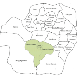
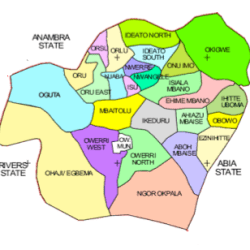
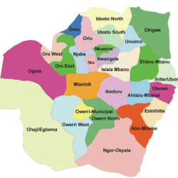
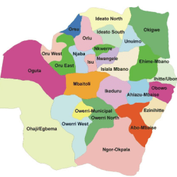
Imo State is administratively divided into 27 LGAs (Local Government Areas) namely:
- Aboh Mbaise
- Ahiazu Mbaise
- Ehime Mbano
- Ezinihitte Mbaise
- Ideato North
- Ideato South
- Ihitte/Uboma
- Ikeduru
- Isiala Mbano
- Isu
- Mbaitoli
- Ngor Okpala
- Njaba
- Nkwerre
- Nwangele
- Obowo
- Oguta
- Ohaji/Egbema
- Okigwe
- Onuimo
- Orlu
- Orsu
- Oru East
- Oru West
- Owerri Municipal
- Owerri North
- Owerri West

Aboh Mbaise Local Government Area in Imo State

Oru West L.G.A. Imo State

Orlu Local Government Area, Imo State

Okigwe Local Government Area, Imo State
In the pre-colonial period, what is now Imo State was a part of medieval Kingdom of Nri and the later Aro Confederacy before the latter was defeated in the early 1900s by British troops in the Anglo-Aro War. After the war, the British incorporated the area into the Southern Nigeria Protectorate which later merged into British Nigeria in 1914; after the merger, Imo became a centre of anti-colonial resistance during the Women’s War.
After independence in 1960, the area of the present-day Imo was a part of the post-independence Eastern Region until 1967 when the region was split and the area became part of the East Central State. Less than two months afterwards, the former Eastern Region attempted to secede in the three-year long Nigerian Civil War with Imo as a part of the secessionist, Igbo nationalist state of Biafra.
The area was hard fought over throughout the war with Owerri and its surrounding area exchanging hands twice before Owerri was named the Biafran capital in 1969.
The present-day Imo State was captured by federal forces in early 1970 with Operation Tail-Wind taking the city and ending the war.
At the war’s end and the reunification of Nigeria, the East Central State was reformed until 1976 when Imo State was formed.
15 years after, Imo State was divided with eastern Imo being broken off to form the new Abia State.
