Municipal District 3: Boundaries, Areas, Neighborhoods, Population
Municipal District 3, covering its creation, population, geographic boundaries, neighborhoods, and urban importance within the city.
Municipal District 3 is a strategically planned administrative area that reflects the city’s modern approach to urban growth and territorial organization. Established as part of the 1995 Master Plan, this district was designed to manage population expansion, improve service delivery, and strengthen neighborhood identity in a rapidly developing urban environment.
With more than 75,000 inhabitants, a well-defined territorial extension, and multiple recognized districts, Municipal District 3 plays a key role in balancing residential life, mobility, and municipal governance. This in-depth review explores its origins, geographic layout, demographic data, and most notable neighborhoods.
Creation and Urban Planning Background
Establishment Under the 1995 Master Plan
Municipal District 3 was officially created on December 6th as a direct outcome of the 1995 Master Plan, a landmark urban planning initiative aimed at restructuring the city into more efficient and manageable districts.
The Master Plan emphasized:
Decentralized administration
Balanced population distribution
Improved infrastructure planning
Municipal District 3 emerged from this vision as a modern district aligned with long-term urban sustainability.
Purpose of the District’s Creation
The formation of the district helped local authorities better address:
Rapid residential growth
Transportation needs
Access to public services
By defining clear boundaries and neighborhood units, the district improved governance and community participation.
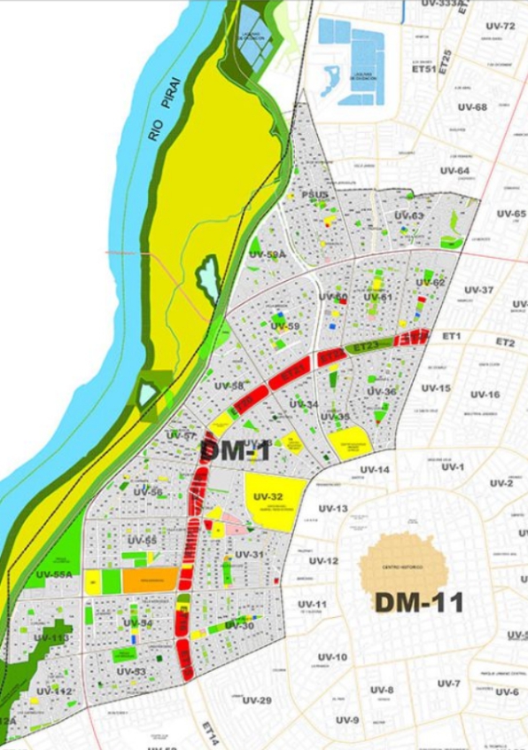
Geographic Location and Boundaries
Strategic Urban Position
Municipal District 3 extends across a significant portion of the city, offering excellent connectivity and access to major transportation corridors. Its location makes it an important residential and transit-linked district.
Defined Territorial Limits
The district spans:
From the second to the fifth ring road
Between La Barranca Avenue, Radial 12 Avenue, Brasil Avenue, and the San Pablo Extension
These boundaries provide clear jurisdictional clarity and support efficient urban mobility.
Territorial Extension and Land Area
Total Surface Area
Municipal District 3 covers approximately 1,022 hectares, making it a moderately sized but densely utilized urban district.
This land area supports:
Residential neighborhoods
Community facilities
Urban infrastructure
The balance between size and population density contributes to efficient land use.
Population and Demographic Overview
Total Population Statistics
According to the 2012 Census, Municipal District 3 has a population of approximately 76,000 inhabitants, positioning it as a mid-sized but influential district within the city.
Population Density and Urban Life
The population size reflects:
High residential demand
Active neighborhood development
Strong need for coordinated municipal services
This density fosters vibrant community interaction and economic activity.
Administrative Structure and Neighborhood Units
Neighborhood Units
Municipal District 3 is organized into 11 neighborhood units, which function as administrative subdivisions to improve planning, representation, and service delivery.
Total Neighborhoods
The district contains 30 neighborhoods, each with its own local character, history, and social dynamics.
This structure allows:
Localized governance
Targeted infrastructure projects
Strong neighborhood identity
Most Recognized Districts Within Municipal District 3
Well-Known and Historic Districts
Municipal District 3 includes several districts that are widely recognized for their history, population size, or strategic location. Among the best-known are:
Estación Argentina
El Trompillo
San Antonio
Pajonal
Cañada El Carmen
Polanco Viejo
Convifag
Héroes del Chaco
Ángel Foianini
Petrolero Sur
Ñuflo de Chávez
These districts contribute significantly to the social, cultural, and economic fabric of the municipality.
Residential Characteristics of Municipal District 3
Housing and Urban Layout
The district is predominantly residential, featuring:
Established neighborhoods
Mixed housing densities
Community-focused streets
This residential composition supports family life, local commerce, and neighborhood cohesion.
Community Living Environment
Municipal District 3 offers an urban lifestyle that balances accessibility with community identity, making it an attractive area for long-term residents.
Transportation and Connectivity
Access to Major Roads and Avenues
Being located between major ring roads and avenues ensures:
Efficient traffic flow
Strong public transportation access
Easy connection to other districts
These transportation advantages enhance daily mobility for residents.
Public Infrastructure and Municipal Services
Service Distribution
Thanks to its structured neighborhood units, Municipal District 3 benefits from:
Organized public service delivery
Planned infrastructure development
Clear administrative oversight
This structure supports long-term urban functionality.
Social Identity and Community Participation
Neighborhood Engagement
Residents of Municipal District 3 maintain strong neighborhood ties, often participating in community initiatives and local decision-making processes.
Civic Importance
The district’s organization encourages civic participation and collaboration between residents and municipal authorities.
Economic and Urban Importance
Contribution to City Development
Municipal District 3 serves as a vital residential and transit-linked zone that supports the city’s broader economic and social systems.
Its population base contributes to:
Workforce availability
Local commerce growth
Urban stability
Future Outlook and Urban Development
Planned Growth and Sustainability
With its origins in the 1995 Master Plan, Municipal District 3 is well-positioned for continued, sustainable growth.
Challenges and Opportunities
Future development will focus on:
Infrastructure upgrades
Preserving neighborhood identity
Improving mobility solutions
FAQs About Municipal District 3
1. When was Municipal District 3 created?
It was created on December 6th as part of the 1995 Master Plan.
2. How many people live in Municipal District 3?
The district has approximately 76,000 inhabitants, according to the 2012 Census.
3. What is the size of Municipal District 3?
It covers an area of 1,022 hectares.
4. How many neighborhood units does the district have?
Municipal District 3 is divided into 11 neighborhood units.
5. How many neighborhoods are included?
The district includes 30 neighborhoods.
6. Which districts are the most well-known?
Notable districts include Estación Argentina, El Trompillo, San Antonio, Pajonal, Héroes del Chaco, Petrolero Sur, and Ñuflo de Chávez, among others.
Municipal District 3 represents a thoughtfully planned urban district born from the city’s 1995 Master Plan vision. With its clear boundaries, organized neighborhood units, and population of over 75,000 residents, it serves as a cornerstone of modern urban administration.
Largest areas by population in Chemba District Council, Tanzania 10 most populated areas in Chemba District Council, Tanzania are: MrijoJangaloLahodaDalaiKwamtoroParangaKidokaSanzawaFarkwaGoima LARGE. List of areas by population in Chemba District Council…
Largest areas by population in Arusha District Council, Tanzania 10 most populated areas in Arusha District Council, Tanzania are: KiranyiOloirienMoivoMatevesKiutuMwandetSokon IIMlangariniOlturotoKimnyak Map of Arusha showing population distribution by areas…
Largest areas by population in Kilosa District Council, Tanzania 10 most populated areas in Kilosa District Council, Tanzania are: DumilaRuahaMikumiMsoweroRudewaMtumbatuMvumiKisangaMkwataniRuhembe LARGE. List of areas by population in Kilosa District Council…
Largest areas by population in Bahi District Council, Tanzania 10 most populated areas in Bahi District Council, Tanzania are: BahiChifutukaLamaitiChikolaMpamantwaMsisiZankaIbihwaMpalangaBabayu LARGE. List of areas by population in Bahi District Council…
Largest areas by population in Kondoa District Council, Tanzania 10 most populated areas in Kondoa District Council, Tanzania are: PahiKikoreKiseseHaubiKalambaHondomairoItaswiKwadeloKeikeiMnenia LARGE. List of areas by population in Kondoa District Council…
Largest areas by population in Siha District Council, Tanzania 10 most populated areas in Siha District Council, Tanzania are: Sanya JuuKaransiNgarenairobiNdumetiGararaguaMakiwaruDonyomurwakNasaiOrmeliliKirua LARGE. List of areas by population in Siha District…
Largest areas by population in Muheza District Council, Tanzania 10 most populated areas in Muheza District Council, Tanzania are: KwemkabalaNgomeniKiluluMkuziMlinganoLusangaKigombeGengeMajengoKwafungo LARGE. List of areas by population in Muheza District Council…
Largest areas by population in Kilindi District Council, Tanzania 10 most populated areas in Kilindi District Council, Tanzania are: KibirashiMsanjaKimbeKwedibomaNegeroKilindiPagwiSongeBokwaKisangasa LARGE. List of districts by population in Dodoma from largest…
Largest areas by population in Ngorongoro District Council, Tanzania 10 most populated areas in Ngorongoro District Council, Tanzania are: SoitsambuOlolosokwanNainokanokaEnduleniArashEnguserosambuNaiyobiMalamboAlailelaiOrgosorok LARGE. List of areas by population in Ngorongoro District Council…
Largest areas by population in Hai District Council, Tanzania 10 most populated areas in Hai District Council, Tanzania are: Machame KaskaziniMnadaniMuunganoMasama KusiniBomang’ombeMasama RundugaiBondeniRomuMasama MasharikiKIA LARGE. List of areas by population…
Largest areas by population in Handeni District Council, Tanzania 10 most populated areas in Handeni District Council, Tanzania are: MkataSegeraNdolwaMazingaraSindeniKang’ataMisimaKomkongaKabukuKwamsisiKwamatuku LARGE. List of areas by population in Handeni District Council…
Largest areas by population in Meru District Council, Tanzania 10 most populated areas in Meru District Council, Tanzania are: UsariverImbaseniKikatitiMaji ya ChaiAkheriAmbureniMaroroniKing’oriMalulaUwiro LARGE. List of areas by population in Meru…
Largest areas by population in Longido District Council, Tanzania 10 most populated areas in Longido District Council, Tanzania are: EngarenaiborKimokouwaKamwan aOlmologGelai MeirugoiNamangaMundararaOrbombaKetumbeineGelai Lumbwa LARGE. List of areas by population in…
Largest areas by population in Korogwe District Council, Tanzania 10 most populated areas in Korogwe District Council, Tanzania are: MomboHaleMswahaMagomaMazindeMkomaziMkalamoMkumbaraMakuyuniMashewa LARGE. List of areas by population in Korogwe District Council…