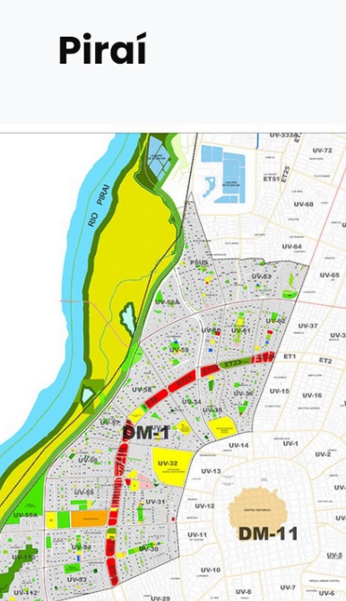
Piraí – Municipal District 1: Boundaries, Population, Units Neighborhoods
Municipal District 1 Piraí stands as one of the most historically significant and densely populated administrative areas in the western part of the city. Created on September 10, 1954, the district has evolved into a vital urban zone that combines residential neighborhoods, historic communities, and structured municipal planning.
Located strategically between major ring roads and avenues, Municipal District 1 Piraí plays a crucial role in city organization, public services, and population distribution. With over 112,000 inhabitants, it reflects both the city’s past development and its modern urban direction.
This detailed review explores the district’s origins, geographic boundaries, demographic composition, neighborhoods, and long-term importance—offering a complete and trustworthy resource for residents, planners, researchers, and curious readers alike.
Historical Background of Municipal District 1 Piraí
Foundation and Administrative Creation
Municipal District 1 Piraí was officially established on September 10, 1954, during a period of structured urban expansion. The mid-20th century marked a turning point when local governments sought to organize rapidly growing populations into manageable districts.
The creation of the district allowed authorities to:
Improve public administration
Deliver municipal services more efficiently
Recognize historically rooted neighborhoods
This administrative recognition laid the foundation for long-term planning and community identity.
Urban Development Over the Decades
From its early years, Municipal District 1 Piraí transitioned from semi-urban land into a fully developed municipal zone. Housing projects, paved roads, and essential services expanded steadily, helping the district absorb population growth while maintaining neighborhood cohesion.
Geographic Location and Boundaries
Western City Positioning
Municipal District 1 Piraí is located in the western sector of the city, a zone known for residential density and interconnected neighborhoods. Its placement makes it a bridge between older historic areas and newer urban developments.
Defined Urban Limits
The district encompasses:
From the second to the fourth ring road
Between Cristo Redentor Avenue and Piraí Avenue
These boundaries ensure strong connectivity, accessibility, and transport flow while clearly defining the district’s jurisdiction.
Territorial Extension and Urban Scale
Land Area and Distribution
Municipal District 1 Piraí covers approximately 1,578 hectares, making it one of the more expansive administrative districts in the city. This land area supports:
Residential neighborhoods
Community institutions
Public spaces
The size allows for balanced population density without overwhelming infrastructure.
Population Overview and Demographics
Total Population Statistics
According to the 2012 Census, Municipal District 1 Piraí has a population of 112,642 inhabitants, reflecting its importance as a major residential hub.
Gender Distribution
The population is distributed as follows:
55,423 men
57,219 women
This balanced demographic supports diverse community activities, family structures, and workforce participation.
Neighborhood Organization and Administrative Units
Neighborhood Units
The district is divided into 22 neighborhood units, which serve as administrative subdivisions for planning, governance, and service delivery.
Total Neighborhoods
In total, Municipal District 1 Piraí comprises 62 neighborhoods, each contributing to the district’s social and cultural diversity.
This structure allows:
Localized community leadership
Efficient municipal management
Preservation of neighborhood identity
Historic Neighborhoods Within the District
Cultural and Historical Importance
Several neighborhoods within Municipal District 1 Piraí hold historic significance, reflecting early settlement patterns and architectural heritage.
Notable Historic Neighborhoods
Among the most recognized are:
Villa San Luis
Brígida
Villa Mercedes
4 de Noviembre
These communities are valued for their long-standing traditions, established families, and contributions to the district’s identity.
Residential Life in Municipal District 1 Piraí
Housing and Community Structure
The district is primarily residential, featuring a mix of:
Traditional family homes
Medium-density housing
Community-oriented neighborhoods
This residential focus promotes strong social ties and neighborhood cooperation.
Quality of Urban Living
With defined streets, access to main avenues, and proximity to services, Municipal District 1 Piraí offers stable urban living conditions suited for families, professionals, and retirees alike.
Transportation and Connectivity
Ring Roads and Major Avenues
The district’s location between two major ring roads ensures:
Efficient internal movement
Direct access to other city zones
Cristo Redentor Avenue and Piraí Avenue act as essential corridors supporting public and private transportation.
Public Services and Infrastructure
Municipal Planning Advantages
The administrative structure of Municipal District 1 Piraí supports:
Organized waste collection
Educational facilities
Health service access
Well-defined boundaries help municipal authorities deliver services equitably across neighborhoods.
Social and Community Identity
Neighborhood Cohesion
Despite its size, the district maintains a strong sense of local identity. Neighborhood associations and informal community networks play a vital role in preserving traditions and addressing local concerns.
Civic Participation
Residents of Municipal District 1 Piraí have historically shown active engagement in municipal matters, contributing to long-term district stability.
Economic and Urban Significance
Role Within the City
Municipal District 1 Piraí functions as a key residential anchor that supports the city’s workforce and service economy.
Its population density makes it:
A focal point for public investment
An essential component of urban planning
Future Outlook and Urban Sustainability
Growth Management
As the city continues to evolve, Municipal District 1 Piraí remains well-positioned for sustainable development due to its established infrastructure and administrative clarity.
Preserving Historic Identity
Balancing modernization with preservation will be critical in maintaining the district’s cultural heritage while meeting future needs.
FAQs About Municipal District 1 Piraí
1. When was Municipal District 1 Piraí created?
It was officially established on September 10, 1954.
2. Where is Municipal District 1 Piraí located?
It is located in the western part of the city, between major ring roads and avenues.
3. How many people live in the district?
The district has 112,642 inhabitants, according to the 2012 Census.
4. How large is Municipal District 1 Piraí?
It covers approximately 1,578 hectares.
5. How many neighborhoods does it include?
The district includes 62 neighborhoods organized into 22 neighborhood units.
6. Which neighborhoods are historically significant?
Notable historic neighborhoods include Villa San Luis, Brígida, Villa Mercedes, and 4 de Noviembre.
Municipal District 1 Piraí is far more than an administrative boundary—it is a living, evolving urban community with deep historical roots and strong demographic presence. Since its creation in 1954, the district has grown into a well-structured residential zone that supports over 112,000 residents across dozens of neighborhoods.
IPPIS Units & their functions IPPIS (Integrated Payroll and Personnel Information System), a Department in the Ministry of Finance under the Office of the Accountant…
Botswana places, polling units List of places and their polling units in Botswana Independent Electoral Commission of Botswana, 2019 01 Chobe 001 Kasane Plateau0001…
Botswana polling units Independent Electoral Commission of Botswana, 2019 List of polling units in Botswana 01 Chobe 001 Kasane Plateau0001 Plateau Kgotla0002 Plateau…
List of polling units in Botswana The polling units in Botswana are: 01 Chobe 001 Kasane Plateau0001 Plateau Kgotla0002 Plateau Primary School002 Kasane Central0003 Kasane Primary…
Places, polling units in Ngami, Botswana Botswana places, polling units Places and their polling units in Ngami, Botswana 029 Etsha 13-Jao0155 Jao Mobile Stop0156 Mombo Camp0157…
Places, polling units in Okavango, Botswana Botswana places, polling units Places and their polling units in Okavango, Botswana 038 Gani-Nxaunxau0234 Nxaunxau Primary School0235 Tsodilo Mobile Stop0236…
Places, polling units in Tati East, Botswana Botswana places, polling units Places and their polling units in Tati East, Botswana 047 Senyawe0302 Butale Primary School0303 Senyawe Primary…
Places, polling units in Chobe, Botswana Botswana places, polling units Places and their polling units in Chobe, Botswana 001 Kasane Plateau0001 Plateau Kgotla0002 Plateau Primary School002…
Places, polling units in Maun East, Botswana Botswana places, polling units Places and their polling units in Maun East, Botswana are: 008 Thamalakane South0031 Borolong Kgotla0032 Thito…
Places, polling units in Maun West, Botswana Botswana places, polling units Places and their polling units in Maun West, Botswana 019 Komana-Toteng0098 Toteng Primary School0099 Bosetu Residential…