Arochukwu LGA Postal Codes are from 442101 to 442107,
Amaeke Abam
Idima
442106
Itum
442106
Ndi Agwu
442106
Ndi Ebelagu
442106
Ndi Ibom
442106
Ndi Ite
442106
Ndi Nsi
442106
Ugwu Aduenyi.
442106
Arochukwu
Agbagwu
442101
Amangwu
442101
Amannagwu
442101
Amasa
442101
Amoba
442101
Amukwa
442101
Amuvi
442101
Asaga
442101
Atani
442101
Ibom
442101
Isinkpu
442101
Obinkita
442101
Oror
442101
Ugbo
442101
Ugwu Avor
442101
Ugwuakuma
442101
Ujari
442101
Ulughangwu.
442101
Ihechiowa
Aboru
442104
Achara
442104
Agbor
442104
Amaetiti
442104
Amafia
442104
Amamiri
442104
Amiyi
442104
Atan
442104
Ebemofia
442104
Ndiokpo
442104
Nkporo
442104
Obicihie
442104
Obinto
442104
Okpo
442104
Umuchiakuma
442104
Umuye
442104
Umuzomgbo.
442104
Isu
Aba Isu
442103
Amachi
442103
Amakarama
442103
Amukabi
442103
Iheosu
442103
Obieze
442103
Obomime
442103
Ohafor
Amaelu
442107
Amaogbu
442107
Ameke
442107
Amuru
442107
Ndi Ebelagu
442107
Ndi Ememe
442107
Ndi Oji Ugwo
442107
Ndiebe
442107
Ndiya
442107
Oduenyi
442107
Ozu Abam.
442107
Ovukwu Abam
Ahuma
442105
Atan
442105
Eziafor
442105
Ndi Oji
442105
Ndi Okereke
442105
Ndi Okorie
442105
Ndi Okwara.
442105
Ututu
Abuma
442102
Amaebem
442102
Amaeke
442102
Amakpofia
442102
Amankwu
442102
Amasa
442102
Amatiti
442102
Amodu
442102
Eziama
442102
Nkpakpi
442102
Obiagwulu
442102
Obiakana
442102
Obiene
442102
Obijoma
442102
Obiluoko
442102
Ohomja
442102
Ubila
442102
Ugwo-Ogo
442102
Ukwuakwu.
442102
Postal code, postcode and ZIP code
Postal code, postcode
Postal code also known as postcode is a group of characters meant to help post offices send mails and parcels to the right destinations.
The code is usually part of a postal address.
ZIP code
Postal codes are also known as ZIP codes. The term ZIP code is often used in US.
ZIP being the short form of Z: Zone I: Improvement P: Plan code
ZIP code is a system of postal codes used by the United States Postal Service (USPS).
Introduced on July 1, 1963, the basic format consisted of five digits. In 1983, an extended code was introduced, called ZIP+4 ; it included the five digits of the ZIP code, followed by a hyphen and four digits that designated a more specific location.
US delivery system uses a ZIP code for the items shipped to and from overseas and within the country.
Nigeria postal codes
The Nigeria postal codes are of use not only for post offices but also for delivery companies and any person that wants to locate an area for parcel delivery or other purposes.
Postal codes enable delivery companies send parcels to correct destinations easier and faster.
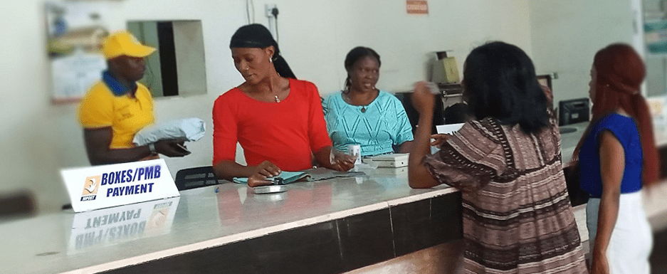
Nigeria postal codes consists of six digits.
NIPOST (Nigerian Postal Service) divides the country into nine regions which make up the first digit of the code. The second and third digits, combined with the first, are the dispatch district for outgoing sorting. The last three digits represent the delivery location. A delivery location can be any of the following; a post office facility, a rural area, or an urban area.
The total postal codes of Nigeria are 982,112 ranging from 100001 to 982112 (Lagos to Benue).
The lowest postal code in Nigeria is 100001, Ikeja in Lagos and the highest is 982112, Mbara, Vandeikya in Benue State.
The main post office or postal head office in each region will has a postal code ending in 0001, so Garki head office in Abuja has the postal code 900001, Ikeja head office in Lagos has 100001, Lokoja in Kogi has 270001 and Port Harcourt has 500001.
Postal codes of Nigeria States
State
Postal code
Abia
440001
Adamawa
640001
Akwa Ibom
520001
Anambra
420001
Bauchi
740001
Bayelsa
561001
Benue
970001
Borno
600001
Cross River
540001
Delta
320001
Ebonyi
840001
Edo
300001
Ekiti
360001
Enugu
400001
Gombe
760001
Imo
460001
Jigawa
720001
Kaduna
700001
Kano
800001
Katsina
820001
Kebbi
860001
Kogi
260001
Kwara
240001
Lagos
100001
Nasarawa
962001
Niger
920001
Ogun
110001
Ondo
340001
Osun
230001
Oyo
200001
Plateau
930001
Rivers
500001
Sokoto
840001
Taraba
660001
Yobe
320001
Zamfara
860001
FCT
900001
Nigeria
Nigeria is a country in Africa, a regional power on the continent and an emerging power on the international scene.
It has 36 states and a Federal Capital Territory, Abuja.
Having being divided into states, the country is further divided into 774 Local Government Areas (LGAs).
The LGAs are under the control of their respective states.
The country has the largest economy in Africa.
Nigeria’s population is over 230 million, making it number 1 most populated country in Africa, and number 6 in the world.
Tiv people of Nigeria
It covers an area of 923,769 square kilometres (356,669 sq mi).
It is situated between the Sahel to the north and the Gulf of Guinea to the south in the Atlantic Ocean.
Abuja City Gate
Nigeria borders Niger in the north, Chad in the northeast, Cameroon in the east, and Benin in the west.
It is often referred to as the Giant of Africa owing to its large population and economy and is considered to be an emerging market by the World Bank.
National Assembly building
However, the country ranks very low in the Human Development Index and remains one of the most corrupt nations in the world.
Maitama, Abuja with Hilton Hotel’s high-rise building in the foreground
The largest city in Nigeria is Lagos, one of the largest metropolitan areas in the world and the largest in Africa.
Lagos, the commercial capital and main sea port city
Nigeria is a multinational state inhabited by more than 250 ethnic groups speaking 500 distinct languages, all identifying with a wide variety of cultures.
The official language is English, chosen to facilitate linguistic unity at the national level.
Nigeria is a founding member of AU (African Union) and a member of other international organizations including UN (United Nations), Commonwealth of Nations and ECOWAS (Economic Community of West African States).
More
Nigeria postal codes Postal codes of Nigeria States StatePostal codeAbia 440001Adamawa 640001Akwa Ibom 520001Anambra 420001Bauchi 740001Bayelsa 561001Benue970001Borno600001Cross River540001Delta320001Ebonyi840001Edo300001Ekiti360001Enugu400001Gombe760001Imo460001Jigawa720001Kaduna700001Kano800001Katsina820001Kebbi860001Kogi260001Kwara240001Lagos100001Nasarawa962001Niger920001Ogun110001Ondo340001Osun230001Oyo200001Plateau930001Rivers500001Sokoto840001Taraba660001Yobe320001Zamfara860001FCT900001 More on Nigeria postal codes The Nigeria postal codes are of…
Abia postal codes The postal, ZIP codes of Abia State Isuikwuato LGA Postal, Zip Codes District: EzereAmaelen 441104Amaja 441104Amaohuru 441104Umuagu 441104Umuakwua 441104 District:…
Isuikwuato postal codes The postal, ZIP codes of Isuikwuato LGA, Abia State, Nigeria District: EzereAmaelen 441104Amaja 441104Amaohuru 441104Umuagu 441104Umuakwua 441104 District: Achara-UturuAmanyanwu 441107Amidi…
Ohafia postal codes The postal, ZIP codes of Ohafia LGA, Abia State, Nigeria District: AbiribaAgboji 442110Amaba 442110Amaeke 442110Amanta 442110Amogudu 442110Amoke 442110 District: Ama-AsatoAbayi-Amaugwu…
Osisioma Ngwa postal codes The postal, ZIP codes of Osisioma Ngwa LGA, Abia State, Nigeria District: AmaitoliAriaria 453113Asamoka 453113Mbutu-Isiahia 453113Mbutu-Umuga 453113Oberete 453113Ogbu 453113Umudi 453113Umuejijie…
Ukwa East postal, ZIP codes The postal, ZIP codes of Ukwa East LGA, Abia State, Nigeria District: AbayiAbam-Nsulu 453109Abam-Nsuluamapa 453109Alaoji 453109Alaoji 453109Amapu 453109Amauvuru 453109Amauvuru 453109Amorji…
Ugwunagbo postal codes The postal, ZIP codes of Ugwunagbo LGA, Abia State, Nigeria District: Ugwu-NagboAbayi 453120Abayi 453120Akanu 453120Akanu 453120Alaoji 453120Alaoji 453120Amaokpu-Umuitiri 453120Amaokpu-Umuitiri 453120Amaorji…
Ukwa West postal, ZIP codes The postal, ZIP codes of Ukwa West LGA, Abia State, Nigeria District: Asa-Northobingwu 452116omuma-Uzor 452116umuekechi 452116umuezeke 452116umuikukor 452116 District: Asa…
Aba North LGA Postal Codes Aba North Postal Codes are from 450101 to 450272. The Local Government Area is located in Abia State, South Eastern…
Abuja postal codes The postal codes for Abuja are: Asokoro900231Central Business District900211Garki Area 1900241Garki Area 2900242Garki Area 3900243Garki Area 7900244Garki Area 8900245Garki Area…
Nigeria postal codes, Kano The postal codes of Kano Municipal LGA (the area that comprises Kano City, the Kano State Capital) are: Abba Rd.700214Abdu…
Kano postal codes The postal codes of Kano Municipal LGA (the area that comprises Kano City, the Kano State Capital) are from 700211…
Postal codes for Kano Postal codes for Kano Municipal LGA (the area that comprises Kano City, the Kano State Capital) range from 700211 to…
Maiduguri postal codes Maiduguri postal codes are from 600211 to 600282. Maiduguri is a city located in Maiduguri LGA, Borno State, North Eastern Nigeria. The postal…
Postal codes for Maiduguri Maiduguri postal codes range from 600211 to 600282. The areas and their codes are: AreaPostcodeBolori600281Bulabulin600221Coca Cola Factory600273College of Agriculture600223Elkanemi islamic Theology600253Gamboru600222Government…
Nigeria postal codes, Maiduguri Maiduguri postal codes are from 600211 to 600282. Maiduguri is a city located in Maiduguri LGA, Borno State, North Eastern Nigeria. The postal…
Aba North Postal Codes Aba North LGA Postal Codes are from 450101 to 450272. Ogbor hillOgbo450101Umuola-Egbelu450101Umuola-Okpulor.450101EziamaEziama450102Osusu450102Umuokpoji450102Uratta.450102Aba TownAba Central450211Abaukwu450251Asaokpuja450261Eziama-Layout450212Iheorji-Layou450241Ohabiam-Layout450252Osusu Layout450271Ovom450221Umungasi450272 Postal code, postcode and ZIP code…
Aba South Postal Codes Aba South LGA Postal Codes are from 450103 to 450104. Abaukwu450104Ariaria450104Asaokpuaja450104Eziukwu450104Obuda.450104OhazuAkoli450103Amanfuru450103Asaeme450103Ihieorji450103Ndiegoro450103Nnetu450103Ohabiam450103Umuagbai450103Umumba450103Umunisi450103Umuogele450103Umuosi.450103 Postal code, postcode and ZIP code Postal code, postcode Postal…
Postal Codes for Bende, Abia Bende Postal Codes are from 441113 to 441123 AlayiAfor-Ukwu441121Agba441121Agbakoli441121Amaeke441121Amagu441121Amaigwu441121Amankalu441121Amaoji441121Amaoku/Amaoku441121Amaokwelu441121Amaozara441121Amautazi/Okputa441121Elugwu441121Etiti Amaelu441121Etiti Amagbo441121Ezi Alayi441121Isiegbu441121Obuohia441121Umunyere.441121BendeEtiti441113Ishimigu441113Isiegbu441113Ndi-Torty441113Ndiekeugo441113Ndiokorukwu441113Nditoli441113Obuohia441113Ogo Ubi Bende441113Okporoenyi441113Okputong441113Onuinyana441113Ukpom441113Umuokoro.441113IgbereAgbo441120Amaetiti441120Amaiyi441120Amakpo441120Amakwu441120Amaofufu441120Amoji441120Eziama441120Ibinanta441120Ibinaukwu441120Ohumola441120Umuisis.441120ItemAkanu441123Akwanu441123Amaekpu441123Amaokwe441123Amaokwo441123Apanu441123Okagwe441123Okayi441123Okoko441123Umuakpa441123Umunnato441123Umuokpo.441123ItumbauzoIbom441114Mbukwa441114Ndi-Iwo441114Ntalakwu441114Okpoedi441114Umuokpe.441114NkpaAmadiaba441117Amaedukwo441117Amaohoro441117Amaokpu441117Eluama441117Muegwu441117Nkporo441117Odua441117Okpobia441117Ugwu441117Umuede.441117Ozui-TemAmaeke441118Amagbo441118Amaukwu441118Ebem441118Elugwumba441118Idiagbo441118Ihie Mba441118Mgbele441118Ndiaikpakpim441118Ndiobu441118Ndiokoroguodu441118Ndiombe441118Obuofia441118Ofiavu441118Ogboko441118Umukpti441118Umuobia441118Umuokoroali441118Umuolazi.441118UgwuekeAmaba441122Amabanta441122Amaeze441122Amagu/Amaba441122Amakwu441122Amangwu441122Amaokayi441122Amauta441122Amiyi441122Ezenta441122Ezeukwu441122Ndielu441122Umungwere.441122Umuhu-EzechiAchi441116Amabo441116Amagbo441116Amaugwu441116Amazo441116Ameke441116Isiegbu441116Ndiagbo441116Neke-Necha441116Okputo441116Umukpube.441116Umu-MenyiAkoli Imenyi441119Amaoji441119Amaukwu441119Elu-Lodu441119Lodu441119Lohum.441119UzuakoliAgbozu441115Amamba441115Amankwo441115Eluama441115Ngwu.441115 Postal code, postcode and ZIP…