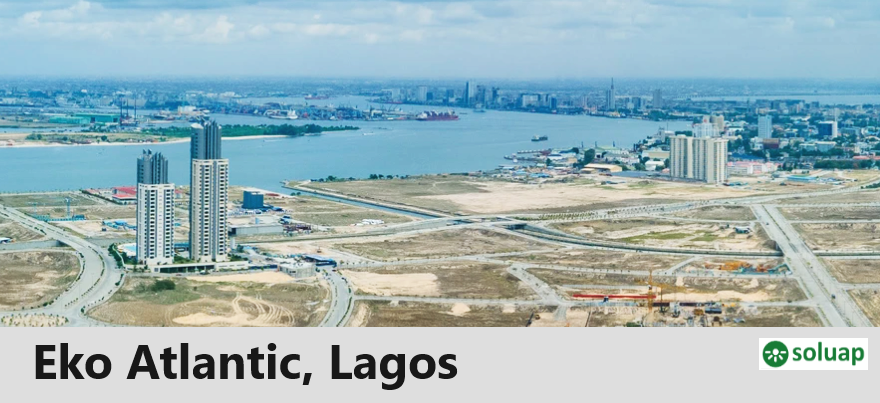
An important accomplishment thus far in Eko Atlantic City is the progress achieved on the construction of the ‘Great Wall of Lagos’. The Great Wall of Lagos was constructed to protect the shoreline of Victoria Island and the early phases of Lekki from coastal erosion.
Before the construction of The Great Wall, the waves from the Atlantic Ocean would regularly flood Victoria Island and the early phases of Lekki, threatening countless lives and businesses.
The Great Wall of Lagos, reaching a total of 8.5km in length when completed, has already achieved its primary goal of protecting Victoria Island from Coastal Erosion. Once completed the wall will protect the early phases of Lekki from coastal erosion as well.
To understand the Great Wall of Lagos, we have to start from the very beginning of the story of Eko Atlantic City.
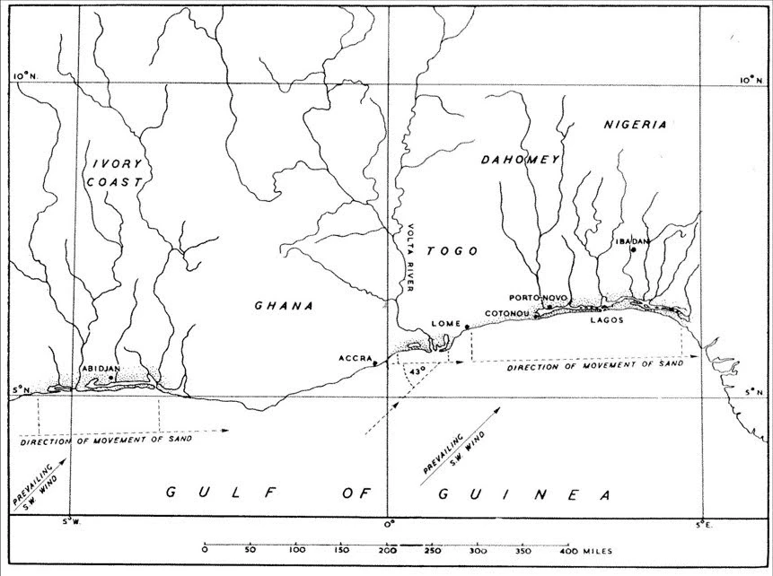
Since the beginning of the last century, records have indicated that sand and sedimentary materials along the coast of the region of West Africa have been transported from West to East by ocean currents. This process of transportation is known as a littoral drift.
Over time, interruptions to the littoral drift had appeared in the form of river dams, major port developments, and other coastal disruptions such as shipwrecks. These interruptions resulted in large sand deposits in some areas and the extensive erosion of land in other areas.
MAP SHOWING LITTORAL DRIFT IN ACTION
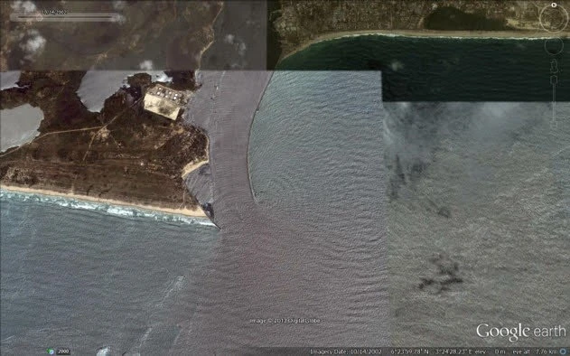
SATELLITE IMAGE OF THE COMMODORE CHANNEL IN 2005 SHOWS THAT BAR BEACH NO LONGER EXISTED. THE SAND IN THIS AREA WAS COMPLETELY ERODED
In Lagos, the genesis of the interruption to the littoral drift came with the construction of the rock moles at the entrance to the Port of Lagos. Before the moles were built large vessels delivering goods to Lagos were required to drop anchor some distance offshore due to the shallow waters in the Commodore Channel, the channel which led to the pre existing Port in Lagos.
To enable delivery of cargo to Lagos Port, smaller vessels would be dispatched to the larger vessels anchored offshore and convey the cargo into the Port, a tedious and inefficient exercise. A major upgrade of the Port of Lagos was apparent and much needed to expand trade and economic growth.
To improve access to the Port of Lagos marine engineers built the East and West Moles. The construction of these two moles allowed for the dredging of the Commodore Channel which would allow larger vessels to enter the Port of Lagos.
Construction of the two moles began in 1905 and was completed in 1912, allowing larger trade ships to freely enter and exit the Port of Lagos and discharge their cargo directly, increasing the volume of trade through this vital new trade hub; the development and extension of the Port of Lagos played a major role in establishing Lagos as one of the major economies on the African continent.
However, constructing these moles interrupted the littoral drift. Sand and sedimentary materials which were previously deposited on the shores of Victoria Island and Lekki were now being trapped on the West side of the Port of Lagos.
Erosion ensued to the East of the Commodore Channel i.e. Bar Beach and the coastline of the Lekki Peninsula.By 2005, some 100years after the construction of the moles, 2 kilometers depth of beach front, the entire Bar Beach, was lost to erosion leaving Victoria Island directly exposed to heavy ocean surges and with no protection from the Atlantic Ocean.
Victoria Island and Lekki’s businesses,residents, and properties were now under severe threat.
Urgent action was required to avert an ecological disaster and the potential loss of the busy commercial hub of Lagos Victoria Island.
Lagos communities Lagos, Nigeria’s top business destination, has 5 divisions, 20 local government areas, 37 local council development areas and, 40 state…
BEACHES IN LAGOS La Manga Luxury Beach Contact: Tel: 0703 724 7212, Email: info@lamangailashe.com Address: Ilashe Island, Amuwo Odofin For more information, please…
Resorts in Lagos La Campagne Tropicana Beach Resort ADDRESS Ikegun, Ibeju-Lekki Local Govt. Area off Lekki / Epe Expressway, Lagos, Nigeria. Phone (+234)07085292796…
Lagos State New Towns Development Authority The Lagos State New Towns Development Authority is a Lagos State Government Agency that develops new towns with functional infrastructure…
Lagos International Airport The Lagos International Airport airport is Nigeria’s busiest airport followed by Nnamdi Azikiwe International Airport, Abuja. The Lagos International Airport…
Abidjan-Lagos Corridor Highway The 1,028-kilometre Abidjan-Lagos Corridor carries more than 75 per cent of trade volume in West Africa, links vibrant seaports, and…
NKST Churches in Lagos NKST has many churches in Lagos. Among the churches are 3 major ones, namely: NKST Lagos at Ojo NKST Abule-Egba…
List of NKST churches in Lagos NKST has numerous churches in Lagos. The 3 major ones are: NKST Lagos at Ojo NKST Abule-Egba NKST Alagomeji NKST…
Lagos official symbol Lagos state government’s official symbol, logo or seal came into being by virtue of the Seal of Lagos State Government…
List of Lagos LGAs (Local Government Areas) The LGAs (Local Government Areas) in Lagos are: AgegeAjeromi-IfelodunAlimoshoAmuwo-OdofinApapaBadagryBadagry DivisionEpeEpe DivisionEti-OsaIbeju-LekkiIfako-IjayeIkejaIkeja DivisionIkoroduIkorodu DivisionKosofeLagos DivisionLagos IslandLagos MainlandMushinOjoOshodi-IsoloShomoluSurulere Lagos Lagos is the…
Lagos LGAs and administrative capitals Local Government Areas and their administrative capitals in Lagos LGA: AgegeCapital: Agege LGA: Ajeromi-IfelodunCapital: Ajeromi/Ifelodun LGA: AlimoshoCapital: Ikotun LGA: Amuwo-OdofinCapital:…
10 Most populated LGAs in Lagos Top 10 most populated LGAs (Local Government Areas) in Lagos State, Nigeria AlimoshoAjeromi-IfelodunKosofeMushinOshodi-IsoloOjoIkoroduSurulereAgegeIfako-Ijaye List of LGAs in Lagos by population.…


")


")