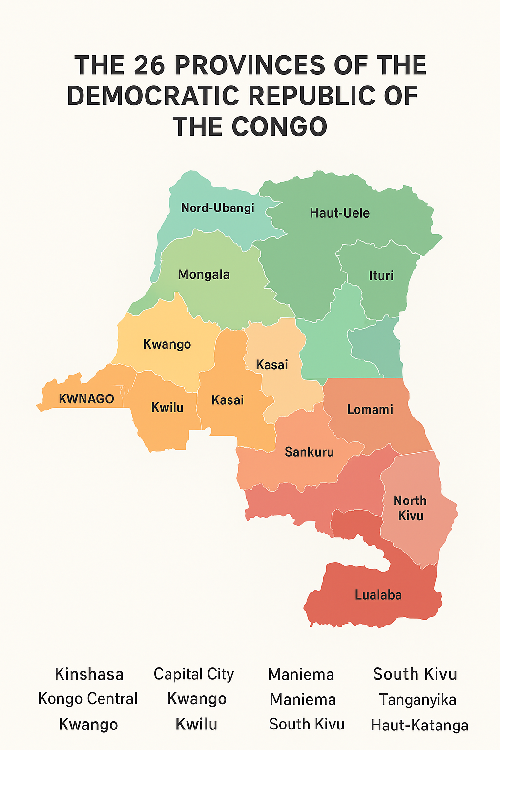
The 26 Provinces of DRC (Democratic Republic of Congo) with History, Geography & Culture
The Democratic Republic of Congo is divided into twenty six provinces. The provinces are then divided into districts. The districts are divided into territories.
List of the 26 Provinces of DRC
The 26 Provinces of DRC (Democratic Republic of Congo) are:
Kinshasa
Kongo Central
Kwango
Kwilu Province
Mai-Ndombe Province
Kasaï Province
Kasaï-Central
Kasaï-Oriental
Lomami Province
Sankuru
Maniema
South Kivu
North Kivu
Ituri Province
Haut-Uele
Tshopo
Bas-Uele
Nord-Ubangi
Mongala
Sud-Ubangi
Équateur
Tshuapa
Tanganyika Province
Haut-Lomami
Lualaba Province
Haut-Katanga Province
The Democratic Republic of the Congo (DRC) is the largest country in Sub-Saharan Africa and one of the most culturally diverse nations in the world. To manage its vast size and population, the country is divided into 26 provinces. These provinces were officially established in 2015, when the government restructured the previous 11 provinces into smaller units to bring governance closer to the people, improve administration, and promote regional development.
Each province is further divided into districts and then into territories, ensuring local governance can function effectively in even the most remote areas. This division reflects the DRC’s geographical diversity, ranging from tropical rainforests and volcanic mountains to savannas and river basins.
Kinshasa (Capital City-Province)
Kinshasa is not only the capital city but also one of the 26 provinces. With over 15 million people, it is the largest city in the country and one of the most populous cities in Africa. Kinshasa sits along the Congo River, directly facing Brazzaville, the capital of the Republic of Congo. Known for its vibrant music scene, bustling economy, and cultural influence, Kinshasa is the political and economic heartbeat of the nation.
Kongo Central
Kongo Central borders the Atlantic Ocean, giving the DRC its only seacoast. Historically called Bas-Congo, this province is home to the Kongo people, one of the most influential ethnic groups in Central Africa. It’s a region of historical importance, as it was one of the first contact points with Europeans during the colonial period.
Kwango
Kwango is known for its vast savannas and agricultural potential. The province is rich in traditions, with local communities practicing subsistence farming and fishing. Its cultural life is deeply tied to the Kwango River, which flows through the region.
Kwilu
Kwilu is largely an agricultural province, producing cassava, maize, and palm oil. It’s also a region of political significance, as it was the birthplace of Pierre Mulele, a revolutionary leader in Congolese history.
Mai-Ndombe
Named after Lake Mai-Ndombe, this province is rich in biodiversity and ecological resources. Its forests are part of the Congo Basin, which plays a key role in the fight against climate change by absorbing carbon dioxide.
Kasaï
Kasaï Province is a land of contrasts, with fertile lands and a history tied to the diamond trade. It was once part of the larger Kasaï-Occidental province before the 2015 reform.
Kasaï-Central
This province is at the heart of traditional Luba culture. It has faced challenges in recent years due to political unrest but remains a region of resilience and cultural pride.
Kasaï-Oriental
Known for its diamond mines, Kasaï-Oriental has been both blessed and challenged by its natural wealth. The provincial capital, Mbuji-Mayi, is sometimes referred to as the “Diamond Capital of the World.”
Lomami
Lomami is a relatively new province, carved out of Kasaï-Oriental. Its economy is driven by farming and trade, with a growing interest in mining.
Sankuru
Sankuru is covered in dense forests and is one of the least populated provinces. It is home to unique wildlife and traditional communities.
Maniema
Maniema lies in the heart of the DRC, with lush forests and mineral resources. Gold, diamonds, and coltan are abundant here, but infrastructure challenges limit development.
South Kivu
Bordering Rwanda, Burundi, and Lake Tanganyika, South Kivu is a province of natural beauty and strategic importance. The capital, Bukavu, is known for its scenic hills and lakeside setting.
North Kivu
North Kivu has been a center of conflict but also of resilience. It is home to Virunga National Park, Africa’s oldest national park and a UNESCO World Heritage Site, where endangered mountain gorillas live.
Ituri
Ituri is one of the most mineral-rich provinces in the country. Gold mining dominates its economy, but the province has also faced challenges from armed conflicts.
Haut-Uele
Located in the northeast, Haut-Uele is known for its wildlife, particularly in Garamba National Park, home to elephants and rare white rhinoceroses.
Tshopo
With its capital in Kisangani, Tshopo is one of the largest provinces by land area. The Congo River flows through it, making it an important hub for transport and trade.
Bas-Uele
A sparsely populated province, Bas-Uele is covered in forests and savannas. Its economy relies mainly on agriculture and hunting.
Nord-Ubangi
Nord-Ubangi shares borders with the Republic of Congo and the Central African Republic. Its economy is based on cross-border trade and farming.
Mongala
Mongala is a heavily forested province where fishing and farming are the main livelihoods. The Congo River is a vital lifeline for its communities.
Sud-Ubangi
Sud-Ubangi, located along the Ubangi River, is a fertile agricultural area. It has cultural ties with neighboring countries, particularly the Central African Republic.
Équateur
Once one of the largest provinces before the reform, Équateur is now smaller but still rich in biodiversity. Its rainforests are home to endangered species like bonobos.
Tshuapa
Tshuapa is named after the Tshuapa River. It is mostly rural, with communities relying on small-scale farming, hunting, and fishing.
Tanganyika
Tanganyika borders Lake Tanganyika, one of the largest freshwater lakes in the world. The province is known for its fishing industry and natural beauty.
Haut-Lomami
Haut-Lomami has significant agricultural potential, with crops like maize and cassava being widely cultivated. Mining also plays a growing role in its economy.
Lualaba
Lualaba is one of the most resource-rich provinces in the DRC. It’s part of the Copperbelt, producing copper and cobalt, vital for global technology industries.
Haut-Katanga
Haut-Katanga is another key mining province, with its capital in Lubumbashi, the country’s second-largest city. It serves as a commercial and industrial hub for the region.
The 26 provinces of the Democratic Republic of the Congo represent not only administrative boundaries but also the country’s rich diversity in culture, geography, and natural resources. From the diamond-rich Kasaï region to the gorilla-filled forests of North Kivu, each province contributes uniquely to the identity and potential of the DRC. Despite challenges of governance, infrastructure, and conflict, the provinces are central to the country’s path toward stability and growth.
More
Borno Geography, Economy, History, and Culture Borno is a notable state in northeastern Nigeria, known for its diverse landscape, significant agricultural activities, and strategic geographic positioning.…
Geography of Benin Republic Benin is located in West Africa in the tropical zone between the equator and the Tropic of Cancer (between the…
Sangha Department, Republic of Congo Sangha is one of the departments in the Republic of Congo, known for its rich natural resources, diverse ecosystems, and…
Pool Department, Republic of Congo The Pool Department is an essential administrative and geographical division in the Republic of Congo. It surrounds the Pool Malebo,…
Cuvette Department, Republic of Congo The Cuvette (Bowl) Department of the Republic of Congo is one of the country’s administrative regions, often described as a…
Plateaux Department, Republic of Congo The Plateaux Department (French: Département des Plateaux), also known as “Trays,” is an administrative division in the Republic of Congo.…


")

