What is today known as Bauchi State was created in 1976 from the North Eastern State of Nigeria. According to the 1991 census, the state has a population of 3,836,333 after the creation of Gombe State in 1996. Bauchi State is one of the states in Northern part of Nigeria that spans two distinctive vegetation zones, namely the Sudan savannah and the Sahel Savannah.

The Sudan savannah type of vegetation covers the southern part of the state. Here, the vegetation gets richer and richer towards the South, especially along water sources or rivers but generally, the vegetation is less uniform and grasses are shorter than what obtains further South, that is in the forest zone of the middle belt. The Sahel type of Savannah which is also known as the semi-desert vegetation becomes manifest from the middle of the state as one moves from the South to the Northern part of the State.
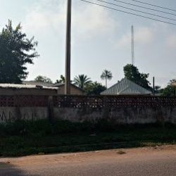
The characteristics of this type of vegetation comprise of isolated stands of thorny shrubs. On the other hand, the southern part of the state is mountainous as a result of the continuation of the Jos – Plateau, while the northern part is generally sandy.①
The focus of many African Government has always been the development of various communities making up the state and the great effort in putting up structures and infrastructure for building a virile society. The creation of Bauchi State, Nigeria, on the 3rd of February 1976 by the military administration of the late Head of State, General Murtala Ramat Muhammad was in line with that philosophy and concept of developing various segments of the Nigerian society.

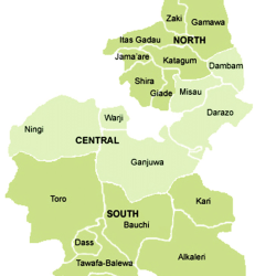
By the time it was created it was thus structured on 16 administrative local councils made up of Bauchi, Tafawa Balewa, Darazo, Alkaleri, and Dass. Others were Jama’are, Katagum, Gamawa, Misau, Shira and Ningi. The rest were Gombe, Tangale Waja, Yamaltu/Deba, Kaltungo and Dukku. However, in 1996, the military administration of late General Sani Abacha created additional State. And thus Gombe State was carved out of the old Bauchi State, as a result of some political and administrative changes in the states.

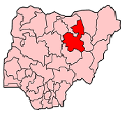
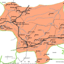
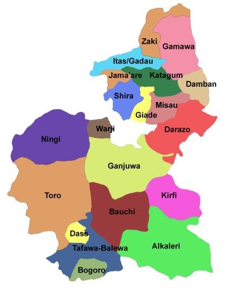
The new Bauchi State was restructured to be based on 20 administrative Local councils. These are Alkaleri, Bauchi, Bogoro, Dass, Darazo, Dambam, Giade, Gamawa, Ganjuwa, Itas/Gadau, Katagum, Kirfi, Misau, Ningi, Jama’are, Shira, Tafawa Balewa, Toro, Warji and Zaki. Geography: Geographically, Bauchi State of Nigeria lies between the latitude 90030 and 12030 North of the Equator. It is equally located between the longitudes 8050 and 110 east of the Greenwich meridian. With total land maps of 49,259.01 square kilometres, Bauchi State shares boundaries to the east with Adamawa, Yobe and Gombe State. To the south, it equally shares common boundaries with plateau and Taraba State, while to the north it is with Kano and Jigawa State, and to west with Kaduna State.

Bauchi State is being ranked high in matters of the caliphate system in Nigeria today. Topographically, Bauchi State is generally divided into two main vegetation zones of the Sudan Savannah and the Sahel Savannah. It records annual rainfall of between 1300mm in the Sudan Savannah zone of the state and 700mm in the Sahel Savannah.
Agricultural activities are mainly determined by the presence of this vegetation’s with great significance. Supporting the agricultural activities, apart from the favorable rainfall, there are large bodies of flowing water from rivers across some local government areas, Successive administrations in the state continued to seize this opportunity by employing special agricultural production mechanism through Fadama programmes in collaboration with some international organizations in harnessing agricultural potentials in the State.
The estimated population of the state according to the last reliable census figures in the country is about 3.2 million people and indeed the state has one of the highest population estimates. More significantly, the state records of the highest migration movement in recent years due to the peaceful atmosphere and economic opportunities as well as potential agricultural activities. This population figure of the people of Bauchi State comprises of different ethnic groups, a natural characteristic of all the states in Nigeria. There could be as tens of such ethnic groups, but the main and predominant ones are the Hausa, Fulani, Kanuri, Gerawa, Jarawa, Sayawa, Bolawa and Kare-Kare.
Islam is the major religion of this population, whereas there are also Christians and followers of traditional religions. Islam made it headway into the area in the day’s even preceding the Jihad of Usman Danfodio the great Islamic reformer who founded the vast Sokoto caliphate. Mallam Yakubu, The first Emir of Bauchi and who was from the Gerawa tribe got a strong religious and moral booster from Shehu Usman Danfidio and thus became one of his flag bearers. Other flag bearers of the Shehu from the state are the emirates of Katagum, Jama’are and Misau.
Additionally, dams have been constructed for irrigation purposes in places such as Gubi, Tilden Fulani and Maladumba. All these have been an added imputes to the great majority of the population engaged in farming activities.
This explains why the economy of the state mainly rests on agricultural output. For these cash crops such as groundnuts, cotton, soybeans, cowpeas and many others are produced in large quantity, while food crops such as maize, guinea corn, millet, rice, cassava and the rest are equally cultivated in abundance. Apart from agricultural potentials, the state is equally endowed with natural resources, which remain mainly untapped. These include among others, petroleum resources, Tin, Kaolin, potassium, Silica Sand, Granite, Laterite, Gypsum, copper, Clay, Quartz and columbite.②
References
① www.bauchistate.gov.ng/about-bauchi-state/
② www.bauchistate.gov.ng/
