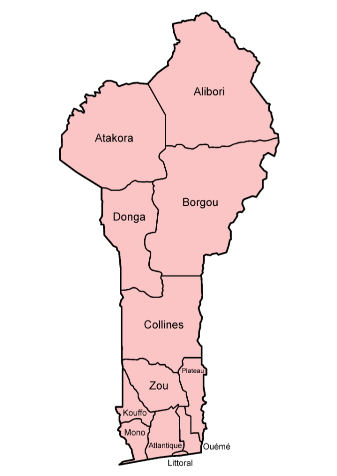
Benin Republic is divided into 12 departments (French: départements), which together are subdivided into 77 communes, forming the primary units of local governance.
Departments and Communes of Benin Republic
This configuration emerged from a major administrative reform in 1999, when the country’s previous six departments were each split into two, giving rise to the current twelve.
The departments of Benin are subdivided into 77 communes, which in turn are divided into arrondissements and finally into villages or city districts.
List of Benin’s 12 Departments and 77 Communes
The communes are listed below, by department:
Alibori
Banikoara
Gogounou
Kandi
Karimama
Malanville
Segbana
Atakora
Boukoumbé
Cobly
Kérou
Kouandé
Matéri
Natitingou
Pehonko
Tanguiéta
Toucountouna
Atlantique
Abomey-Calavi
Allada
Kpomassè
Ouidah
Sô-Ava
Toffo
Tori-Bossito
Zè
Borgou
Bembèrèkè
Kalalé
N’Dali
Nikki
Parakou
Pèrèrè
Sinendé
Tchaourou
Collines
Bantè
Dassa-Zoumè
Glazoué
Ouèssè
Savalou
Savé
Donga
Bassila
Copargo
Djougou
Ouaké
Kouffo
Aplahoué
Djakotomey
Klouékanmè
Lalo
Toviklin
Dogbo-Tota
Littoral
Cotonou
Mono
Athiémé
Bopa
Comé
Grand-Popo
Houéyogbé
Lokossa
Ouémé
Adjarra
Adjohoun
Aguégués
Akpro-Missérété
Avrankou
Bonou
Dangbo
Porto Novo
Sèmè-Kpodji
Plateau
Ifangni
Adja-Ouèrè
Kétou
Pobè
Sakété
Zou
Abomey
Agbangnizoun
Bohicon
Cové
Djidja
Ouinhi
Za-Kpota
Zangnanado
Zogbodomey
Below is a table summarizing each department, with its capital, 2013 population, land area, and, where applicable, the “parent” former department from before the 1999 split.
.
Department
Capital
Population (2013)
Area (km²)
Former Department (pre-1999)
1
Alibori Department
Kandi
868,046
26,242
Former Borgou
2
Atakora Department
Natitingou
769,337
20,499
Former Atakora
3
Atlantique Department
Allada (some sources cite Ouidah)
1,396,548
3,233
Former Atlantique
4
Borgou Department
Parakou
1,202,095
25,856
Former Borgou
5
Collines Department
Dassa-Zoumé (or Savalou, depending on source)
716,558
13,931
Former Zou
6
Donga Department
Djougou
542,605
11,126
Former Atakora
7
Kouffo Department
Aplahoué (or Dogbo-Tota)
741,895
2,404
Former Mono
8
Littoral Department
Cotonou
678,874
79
Former Atlantique
9
Mono Department
Lokossa
495,307
1,605
Former Mono
10
Ouémé Department
Porto-Novo
1,096,850
1,281
Former Ouémé
11
Plateau Department
Pobè (or Sakété)
624,146
3,264
Former Ouémé
12
Zou Department
Abomey
851,623
5,243
Former Zou
Historical Context: Why and How the Split Happened
Prior to 1999, Dahomey (now Benin) was administratively divided into six large departments: Atakora, Atlantique, Borgou, Mono, Ouémé, and Zou.
On 15 January 1999, a law reorganised internal administration: each of these six departments was bifurcated into two, resulting in the current twelve-department structure.
The purpose was to improve administrative efficiency and bring government services closer to local populations.
Although the twelve-department structure was created in 1999, the official capitals for the six newly formed departments were only assigned in 2008.
Geographical & Demographic Patterns
There is a noticeable north-south divide in the distribution of population and geography. The southern departments (e.g., Littoral, Atlantique, Ouémé, Zou, Collines) are relatively small in area but tend to have high population density, reflecting the concentration of urban centres and coastal plains.
In contrast, northern departments (e.g., Alibori, Atakora, Borgou, Donga) cover large land areas, often savanna or semi-arid highlands, and tend to have lower population densities.
The total land area of Benin is approximately 114,763 km².
Administrative Significance: Communes, Decentralization, Local Governance
The 12 departments are subdivided into 77 communes, which are the basic units of local governance.
The 1999 reform transformed the structure of local administration: many of the former under-prefectures or small administrative units were restructured to function as communes, giving local governments more responsibility.
Communes are administered by mayors and municipal councils; they are responsible for local services such as waste management, water supply, infrastructure — though some analyses observe that fiscal decentralization remains limited, as many communes still depend heavily on transfers from the central government.
Why the 1999 Reform Matters
The split ensured more manageable administrative units: by dividing large, often unwieldy departments into smaller ones, the central government made it easier to deliver public services, respond to local needs, and administer rural and remote zones.
It allowed better representation of local identities and interests — especially significant in ethnically and geographically diverse regions.
It enhanced the structure for decentralization and local governance, aligning with broader governance reforms during the 1990s.
The current division of Benin into 12 departments—established through the 1999 administrative reform—represents a significant reorganization aimed at improving governance, decentralization, and service delivery. The structure reflects both geographical realities (north–south disparities, coastal vs inland) and demographic patterns (dense southern urban centers vs sparsely populated northern savannas). Understanding this administrative framework is essential when studying Benin’s politics, governance, local development, or regional demographics.
More
List of Communes in Timiș County The Communes in Timiș County, Romania are: Balinț Banloc Bara Bârna Beba Veche Becicherecu Mic Belinț Bethausen Biled Birda Bogda…
List of Philippine Government Departments and Agencies A directory of 441 government bodies including: Executive Departments (e.g., Department of Education, Department of Health) Constitutional Commissions (e.g., Civil…
List of Barbados Government Departments Barbados Government Departments are the backbone of the island’s public service system. They support citizens, protect national resources, manage critical…
List of Burkina Faso Departments The provinces of Burkina Faso are divided into 351 departments. The well-defined administrative system helps manage its cities, towns, villages,…
List of Benin Ethnic Groups The ethnic Composition of Benin Republic covering major ethnolinguistic groups, language families, regional distribution, and some historical context. According to…
NKST Departments and their leaders Secretariat – General Secretary – Rev EM Shir Treasury – Treasurer – Rev Dzwawua Aku RTS – Provost – Rev…
Ministries, Departments and Agencies (MDA) in Nigeria Nigeria Federal Ministries, Departments and Agencies (MDA) and their codes are: SNMDA CodeOrganization /MinistryMinisterial DepartmentAgency /Parastatal137001Federal Ministry of Industry, Trade…
Chad regions and departments The Republic of Chad has regions which are further divided into departments. The regions and their departments are: RegionDepartmentsBathaBatha Est, Batha…
Benue State Law Courts Departments Following the enactment of the now repealed Decree Number 43 of 1998 which introduced the civil service reforms, the Benue…
Departments in Nigeria Police The Departments in Nigeria Police are: • Finance & Administration• Operations• Logistics & Supply• Crime Investigation• Training• Research & Planning•…
Departments of Ghana Police Service With a staff strength of over 30,000, the GPS is carefully structured in a way that facilitates efficient delivery across…
Departments of National Population Commission, Nigeria Nigeria’s National Population Commission is divided into 8 Departments and 4 units. These are: Departments Planning and ResearchFinance and AccountsCartographyInformation…
Most Populated Departments of Bolivia The most populated departments of Bolivia, ranked from highest to lowest population Most Populated Departments of Bolivia are Santa Cruz…
Tatoos in Benin, Edo State Although Nyandael and Burton stated that tattooing took place during infancy and youth, the information we have is that it…