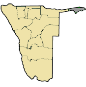
Namibia is a unitary state divided into 14 administrative regions, each with its own regional council. These regions are further divided into 121 constituencies for local governance and electoral purposes.
List of Namibia’s Regions and their Number of Constituencies
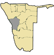
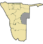
Zambezi Region (8)
Kavango East Region (6)
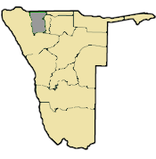
Kavango West Region (8)
Ohangwena Region (11)
Oshikoto Region (11)
Oshana Region (10)
Omusati Region (12)
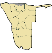
Kunene Region (6)
Erongo Region (7)
Otjozondjupa Region (7)
Omaheke Region (7)
Khomas Region (10) – Includes the capital, Windhoek.
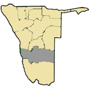
Hardap Region (8)
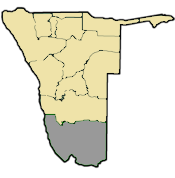
Kharas Region (7)
Zambezi: Map and list of its constituencies
Kabbe
Katima Mulilo Rural
Katima Mulilo Urban
Kongola
Linyanti
Sibida
Judea Lyaboloma
Kabbe South
Erongo: Map and list of its constituencies
Arandis
Daures
Karibib
Omaruru
Swakopmund
Walvis Bay Rural
Walvis Bay Urban
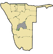
Hardap: Map and list of its constituencies
Aranos
Daweb
Gibeon
Mariental Rural
Mariental Urban
Rehoboth Rural
Rehoboth Urban East
Rehoboth Urban West
Karas: Map and list of its constituencies
Naminüs
Berseba
Karasburg East
Karasburg West
Keetmanshoop Rural
Keetmanshoop Urba
Orangemud
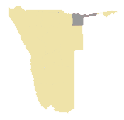
Kavango West: Map and list of its constituencies
Kapako
Mankumpi
Mpungu
Muses
Ncamagoro
Ncuncuni
Nkurenkuru
Tondoro
Kavango East: Map and list of its constituencies
Mashare
Mukwe
Ndiyona
Ndonga Linena
Rundu Rural
Rundu Urban
Khomas: Map and list of its constituencies
John Alfons Pandeni
Katutura Central
Katutura East
Khomasdal
Moses //Garoeb
Samora Machel
Tobias Hainyeko
Windhoek East
Windhoek Rural
Windhoek West
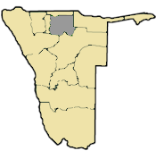
Kunene: Map and list of its constituencies
Epupa
Kamanjab
Khorixas
Opuwo Rural
Opuwo Urban
Outjo
Sesfontein
Omaheke: Map and list of its constituencies
Aminus
Epukiro
Gobabis
Kalahari
Okarukambe
Otjinene
Otjombinde
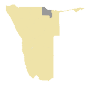
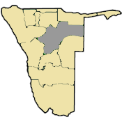
Ohangwena: Map and list of its constituencies
Eenhana
Endola
Engela
Epembe
Ohangwena
Okongo
Omulunga
Omundaungilo
Ondobe
Ongenga
Oshikango
Oshikunde
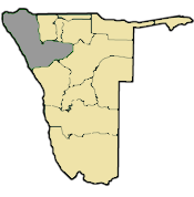
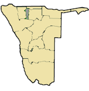
Omusati: Map and list of its constituencies
Anamulenge
Elim
Etayi
Ogongo
Okahao
Okalongo
Onesi
Oshikuku
Otamanzi
Outapi
Ruacana
Tsandi
Oshana: Map and list of its constituencies
Okaku
Okatana
Okatjali
Ompundja
Ondangwa Rural
Ondangwa Urban
Ongwediva
Oshakati East
Oshakati West
Uukwiyu
Uuvudhiya
Oshikoto: Map and list of its constituencies
Eengodi
Guinas
Nehale lyaMpingana
Okankolo
Olukonda
Omuntele
Omuthiyagwiipundi
Onayena
Oniipa
Onyaanya
Tsumeb
Otjozondjupa: Map and list of its constituencies
Grootefontein
Okahandja
Okakarara
Omatako
Otavi
Otjiwarongo
Tsumkwe
Purpose of the Division
Political representation: Constituencies elect members to the National Assembly and Regional Councils.
Administrative efficiency: Regions coordinate local development, service delivery, and government programs.
Decentralization: Brings decision-making closer to communities.
Governance Structure
Regional Councils: Oversee development and administration in each region.
Constituency Councillors: Represent local communities in the Regional Council.
Local Authorities: Manage towns, municipalities, and settlements within constituencies.
World Heritage Sites in Namibia UNESCO World Heritage Sites in Namibia are: Twyfelfontein or /Ui-//aes Namib Sand Sea > View other UNESCO World Heritage Sites…
Namibia National Symbols National Symbols of the Republic of Namibia National symbols are visual and conceptual representations of a nation’s sovereignty, pride, and…
List of Taraba State Constituencies The state constituencies in Taraba are: Ardo-Kola Bali I Bali II Donga Gashaka Gassol I Gassol II Gembu Ibi Jalingo…
List of Kano House of Assembly Constituencies The Kano State legislature (House of Assembly) has 40 constituencies, namely: Ajingi Albasu Bagwai/Shanono Bebeji Bichi Bunkure Dala Dambatta Dawaki…
List of Ekiti federal constituencies The federal constituencies (the areas represented each by a House of Representatives member) in Ekiti State are: Ekiti Central I…


")
