Nigeria states and capitals, population, land area
States of Nigeria; their capitals, population, land and area in Km²
State
Capital
Population
Area (Km²)
Abia
Umuahia
2,833,999
4,857
Adamawa
Yola
3,168,101
37,957
Akwa Ibom
Uyo
3,920,208
6,788
Anambra
Awka
4,182,032
4,761
Bauchi
Bauchi
4,676,465
48,197
Bayelsa
Yenagoa
1,703,358
9,363
Benue
Makurdi
4,219,244
30,755
Borno
Maiduguri
4,151,193
72,767
Cross River
Calabar
2,888,966
22,112
Delta
Asaba
4,098,391
17,095
Ebonyi
Abakaliki
2,173,501
6,342
Edo
Benin City
3,218,332
19,584
Ekiti
Ado-Ekiti
2,384,212
5,797
Enugu
Enugu
3,257,298
7,560
Federal Capital Territory
Abuja
1,405,201
7,569
Gombe
Gombe
2,353,879
17,428
Imo
Owerri
3,934,899
5,135
Jigawa
Dutse
4,348,649
23,415
Kaduna
Kaduna
6,066,562
44,217
Kano
Kano
9,383,682
20,389
Katsina
Katsina
5,792,578
23,822
Kebbi
Birnin Kebbi
3,238,628
36,320
Kogi
Lokoja
3,278,487
29,063
Kwara
Ilorin
2,371,089
33,792
Lagos
Ikeja
9,013,534
3,475
Nasarawa
Lafia
1,863,275
26,633
Niger
Minna
3,950,249
72,065
Ogun
Abeokuta
3,728,098
16,850
Ondo
Akure
3,441,024
15,019
Osun
Oshogbo
3,423,535
8,585
Oyo
Ibadan
5,591,589
27,036
Plateau
Jos
3,178,712
26,539
Rivers
Port Harcourt
5,185,400
10,361
Sokoto
Sokoto
3,696,999
32,146
Taraba
Jalingo
2,300,736
59,180
Yobe
Damaturu
2,321,591
44,880
Zamfara
Gusau
3,259,846
33,667
Total
140,003,542
911,519
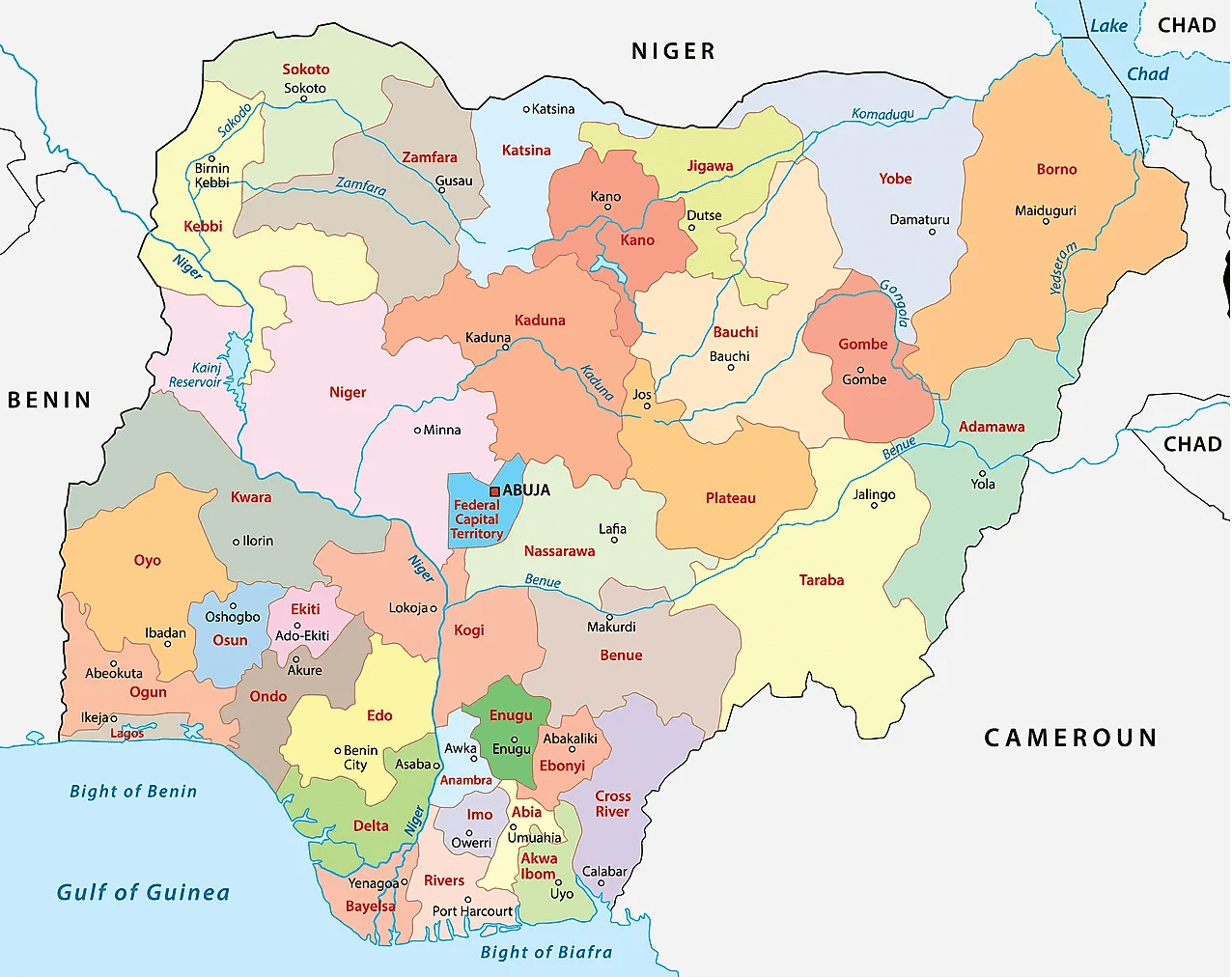
Map of Nigeria’s 36 states & Abuja (the Federal Capital Territory)
States creation, reformation
By the time that Nigeria got independence it was a federation of the three regions, namely:
Western Eastern Northern
Later on another region was added, the Mid-Western Region.
The Mid-Western Region was formed from the Western Region in 1966, and Lagos, the capital, was effectively governed as an unofficial fourth region outside the bounds of the Western Region.
This brought the number of regions to 4 as follows:
Western Mid-Western Western Northern
Under the short-lived military government of Aguiyi-Ironsi, Nigeria was reorganized under a central government. Following a coup which resulted in Aguiyi-Ironsi’s deposition and assassination, Nigeria was reorganized as a federal country again with three of the regions being divided into newer entities and all first-level subdivisions being renamed as states.
Western Region was divided into: Lagos and Western states.
Eastern Region was divided into: East-Central, Rivers, and South-Eastern states;
Northern Region was divided into: Benue-Plateau, Kano, Kwara, North-Central, North-Eastern, and North-Western (Sokoto) states
1976 reformation of Nigeria’s federating units
In 1976, six years after the end of the civil war, the states were further reorganized:
State boundaries and names were also reorganized.
Benue-Plateau state divided into: Benue and Plateau states.
East-Central state divided into: Anambra and Imo states. Federal Capital Territory (Abuja) formed from parts of Niger and Plateau states.
North-Eastern state divided into: Bauchi, Borno, and Gongola states. Niger (Minna) state split from Sokoto.
Western state divided into: Ogun, Ondo, and Oyo states
States of Nigeria from 1987-1991
Akwa Ibom state created from Cross River; Katsina state created from Kaduna
States of Nigeria from 1991-1996
Abia State created from Imo; Bendel State divided into Delta and Edo; Enugu State created from Anambra; Gongola State divided into Adamawa and Taraba; Jigawa State created from Kano; Kebbi State created from Sokoto; Kogi State formed from parts of Benue and Kwara; Osun State created from Oyo; Yobe State created from Borno.
States of Nigeria from 1996
Bayelsa State created from Rivers; Ebonyi State was formed from parts of Abia and Enugu; Ekiti State created from Ondo; Gombe State created from Bauchi; Nasarawa State created from Plateau; Zamfara State was created from Sokoto.
Ghana districts. Population, size of land area and capitals of districts The districts of Ghana and their population, land area and capitals are as follows: DistrictPopulationArea (km.²)CapitalAbura-Asebu-Kwamankese90,093324Abura-DunkwaAccra1,659,136185AccraAdansi East129,3251,380New EdubiaseAdansi West235,680828ObuasiAfigya Sekyere117,653770AgonaAfram…
Tanzania regions: Population, land area and capitals Regions of Tanzania by population, land area and capitals RegionPopulationArea (Km²)CapitalArusha1,694,31033,809ArushaDar es Salaam4,364,5411,393Dar es SalaamDodoma2,083,58841,311DodomaGeita1,739,530 GeitaIringa941,23856,864IringaKagera2,458,02328,388BukobaKatavi564,604 MpandaKigoma2,127,93037,037KigomaKilimanjaro1,640,08713,309MoshiLindi864,65267,000LindiManyara1,425,13146,359BabatiMara1,743,83019,566MusomaMbeya2,707,41060,350MbeyaMorogoro2,218,49270,799MorogoroMtwara1,270,85416,707MtwaraMwanza2,772,50919,592MwanzaNjombe702,097 NjombePemba North211,732574WetePemba South195,116332Chake ChakePwani1,098,66832,407Dar es SalaamRukwa1,004,53968,635SumbawangaRuvuma1,376,89163,498SongeaShinyanga1,534,80850,781ShinyangaSimiyu1,584,157 BariadiSingida1,370,63749,341SingidaTabora2,291,62376,151TaboraTanga2,045,20526,808TangaZanzibar…
10 largest states of Nigeria by land area The 10 largest states of Nigeria by land area are: BornoNigerTarabaBauchiYobeKadunaAdamawaKebbiKwaraZamfara Full list of Nigeria states land size. From largest…
10 smallest states of Nigeria by land area The 10 smallest states of Nigeria by land area are: LagosAnambraAbiaImoEkitiEbonyiAkwa IbomEnuguFederal Capital TerritoryOsun Full list of Nigeria states by…
Tanzania districts: Population, land size and capitals Districts of Tanzania by population, land size and capital DistrictPopulationArea (Km²)CapitalArumeru514,6512,896AkheriArusha281,60883ArushaBabati302,2534,969BabatiBagamoyo228,9679,842ChalinzeBariadi603,6049,777BariadiBiharamulo409,3898,938Biharamulo MjiniBukoba Rural394,0206,993BukobaBukoba Urban80,86880BukobaBukombe395,29810,842UshiromboBunda258,9302,782BundaChake82,998332Chake ChakeChunya205,91527,065MakongorosiDodoma Rural438,86614,004DodomaDodoma Urban322,8112,576DodomaGeita709,0785,880KalangalalaHai258,9352,369Hai MjiniHanang204,6402,918GananaHandeni248,6336,112ChanikaIgunga324,0946,788IgungaIlala634,924210IlalaIleje109,8471,935ItumbaIlemela264,873895IlemelaIramba367,0367,900SheluiIringa Rural245,03319,898IringaIringa Urban106,371160IringaKahama594,8919,461Kahama…
Nigeria’s 36 States and Capitals The 36 States of Nigeria and their capitals are: SNStateCapital1AbiaUmuahia2AdamawaYola3Akwa IbomUyo4AnambraAwka5BauchiBauchi6BayelsaYenagoa7BenueMakurdi8BornoMaiduguri9Cross RiverCalabar10DeltaAsaba11EbonyiAbakaliki12EdoBenin City13EkitiAdo-Ekiti14EnuguEnugu15GombeGombe16ImoOwerri17JigawaDutse18KadunaKaduna19KanoKano20KatsinaKatsina21KebbiBirnin Kebbi22KogiLokoja23KwaraIlorin24LagosIkeja25NasarawaLafia26NigerMinna27OgunAbeokuta28OndoAkure29OsunOshogbo30OyoIbadan31PlateauJos32RiversPort Harcourt33SokotoSokoto34TarabaJalingo35YobeDamaturu36ZamfaraGusau List of Nigeria’s 36 states…
List of Nigeria states and capitals The states and capitals of the Federal Republic of Nigeria are: SNStateCapital1AbiaUmuahia2AdamawaYola3Akwa IbomUyo4AnambraAwka5BauchiBauchi6BayelsaYenagoa7BenueMakurdi8BornoMaiduguri9Cross RiverCalabar10DeltaAsaba11EbonyiAbakaliki12EdoBenin City13EkitiAdo-Ekiti14EnuguEnugu15GombeGombe16ImoOwerri17JigawaDutse18KadunaKaduna19KanoKano20KatsinaKatsina21KebbiBirnin Kebbi22KogiLokoja23KwaraIlorin24LagosIkeja25NasarawaLafia26NigerMinna27OgunAbeokuta28OndoAkure29OsunOshogbo30OyoIbadan31PlateauJos32RiversPort Harcourt33SokotoSokoto34TarabaJalingo35YobeDamaturu36ZamfaraGusau Federal territory (similar…
Biggest states in Nigeria by population Nigeria’s top 10 biggest states by population are: KanoLagosKadunaKatsinaOyoRiversBauchiJigawaBenueAnambra Population size of Nigeria states. From largest to smallest Based on…
Smallest states in Nigeria by population The 10 least populated states of Nigeria are: Federal Capital Territory (FCT), AbujaBayelsaNasarawaEbonyiTarabaYobeGombeKwaraEkitiAbia Full list of population size of Nigeria…
, State Capitals, Land Area, Population, GDP, Subdivisions (Districts, Cities and Municipalities)")


 offices and addresses in 36 States and Abuja")