Ondo State, made up of 18 Local Government Areas is located in the South Western Zone of Nigeria. The state lies between longitudes 4″30″ and 6″ East of the Greenwich Meridian, 5″45″ and 8″ 15″ North of the Equator. This means that the state lies entirely in the tropics. It is bounded in the North by Ekiti/Kogi State; in the East by Edo State; in the West by Oyo and Ogun States and in the South by the Atlantic Ocean.
Land Area
14,788.723 square kilometers.
Population
3,460,877 comprising 1,745.057 Male and 1,715,820 female(as at 2006) and projected population of 4,883,792 comprising 2,462,525 male, 2,421,267 female (by the State Bureau of Statistics)
Map of Bauchi State showing Local Government Areas Local Government Areas of Bauchi State, Nigeria AlkaleriBauchiBogoroDambanDarazoDassGanjuwaGiadeItas/GadauJama’areKatagumKirfiMisauNingiShiraTafawa-BalewaToroWarjiZaki
Map of Plateau State showing Local Government Areas Plateau Local Government Areas Barkin LadiBassaBokkosJos-EastJos-NorthJos-SouthKanamKankeLangtang NorthLangtang SouthManguMikangPankshinQua’an PanRiyomShendamWase
Map of Benue State showing the 23 local government areas Benue State’s 23 local government areas AdoAgatuApaBurukuGbokoGumaGwer EastGwer WestKatsina-AlaKonshishaKwandeLogoMakurdiObiOgbadiboOhiminiOkpokwuOjuOtukpoTarkaUkumUshongoVandeikya
Map of Katsina Ala local government area showing major areas Katsina Ala CapitalKatsina-Ala town Major placesTor DongaAbajiHargaSaiGborAmaafuJoo MbatyoughManorIkoweGbisheSati AgirigiUchaGawaTionkwaseAguYooyoTavachanSolozoKenvanger Council wardsKatsina-Ala TownshipIkyurav-tiev IIkyurav-tiev IIYooyoUtangeTiirIwarMichiheMbakyongoMbajirMbatyura/MberevMbacher Boundaries, Benue StateTo the North, Logo…
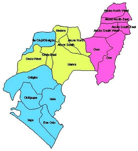
Local Government Areas in Ondo State Ondo State’s Local Government Areas are: Akure South Akure North Ondo East Ondo West Akoko South-West Akoko South-East Akoko North-East…
LOCAL GOVERNMENT AREAS IN ONDO STATE The Local Government Areas in Ondo State are: Akure South Akure North Ondo East Ondo West Akoko South-West Akoko South-East…
Largest Local Government Areas in Ondo State by land area 10 largest Local Government Areas by land area in Ondo State of Nigeria are: IdanreOdigboOseIlajeOwoOndo WestIreleOkitipupaEse-OdoIle-Oluji-Okeigbo LARGE. List of LGAs in…
List of Local Government Areas in Ondo State and their headquarters Ondo State Local Government Areas and their headquarters, administrative capitals LGAHeadquartersAkoko South EastOkaAkure NorthIju/ItaogboluAkoko North EastIkareAkure SouthAkureAkoko South WestIsuaAkoko North…