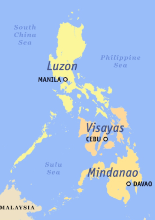
The major islands of Philippine are Luzon, Mindoro, Panay, Negros, Cebu, Samar, Leyte, Bohol, and Paragua (now Palawan). They appear alongside hundreds of smaller islands and island groups, including the Batan Islands, Babuyan Islands, Polillo Islands, Calamianes, and Cuyos
A look at two complete indexes of Philippine islands:
A geographical listing, arranged from north to south, grouped by province or coastline, with the area of each island in square miles.
An alphabetical listing of islands with their general locations.
According to the 1903 census, the Philippine archipelago consisted of:
3,141 islands in total.
1,668 named islands.
1,473 unnamed islets and rocks.
A combined land area of 115,026 square miles.
The geographical section begins with the northernmost islands and proceeds southward, listing:
Island names.
Their province or coastal grouping.
Their land area.
Numerous unnamed islets and rocks where applicable.
Major islands such as Luzon, Mindoro, Panay, Negros, Cebu, Samar, Leyte, Bohol, and Paragua (now Palawan) appear alongside hundreds of smaller islands and island groups, including the Batan Islands, Babuyan Islands, Polillo Islands, Calamianes, and Cuyos.
The document includes a note that it was digitized from a two-column scanned book, so OCR (optical character recognition) errors may occur. Island names and general locations are generally reliable, but some entries may be misordered or contain transcription mistakes. The original census pages should be consulted for exact verification of individual islands.
Overall, this is a historical geographical catalog, not a narrative report. Its primary purpose is to provide a comprehensive inventory of every island recognized in the Philippine archipelago in 1903, including their locations and sizes.
This document is an extracted list from the 1903 Census of the Philippine Islands (Volume I), specifically the section “Islands of the Philippine Archipelago” compiled by George R. Putnam of the U.S. Coast and Geodetic Survey. It is a public-domain historical reference documenting the islands recognized during the 1903 census.
World Heritage Site in Solomon Islands UNESCO World Heritage Site in Solomon Islands is: East Rennell > View other UNESCO World Heritage Sites More on World…
World Heritage Site in Marshall Islands UNESCO World Heritage Site in Marshall Islands is: Bikini Atoll Nuclear Test Site > View other UNESCO World Heritage Sites…
The 10 islands of Cape Verde Cape Verde is made up of 10 islands and eight islets, located some 450 km west of Senegal, approximately 2890…
Cape Verde islands Cape Verde is a West African country located in the central Atlantic Ocean, consisting of 10 volcanic islands with a…
List of Cape Verde islands Cape Verde is made up of 10 islands and eight islets, located some 450 km west of Senegal, approximately 2890…
Philippine Provinces per Region Provinces of Philippine grouped per region. Cordillera Administrative Region (CAR) Abra Benguet Ifugao Kalinga Mountain Province Apayao Region I –…
List of Philippine Government Departments and Agencies A directory of 441 government bodies including: Executive Departments (e.g., Department of Education, Department of Health) Constitutional Commissions (e.g., Civil…