Understanding Latitude: Definition, Key Lines, and Why It Matters
What latitude is, how it divides Earth into hemispheres, key parallels like the Tropic of Cancer, and how scientists measure latitude with precision.
What is Latitude?
Latitude lines, also known as parallels, are imaginary lines that circle the Earth east to west. They measure your distance north or south of the equator (0° latitude), which divides Earth into the Northern and Southern Hemispheres.
Latitude ranges from 0° at the equator to 90° at the North and South Poles.
Lines of latitude are parallel — they are always the same distance apart, unlike longitude lines which meet at the poles.
Each degree of latitude covers about 111 kilometers (69 miles) on Earth’s surface. One degree is further divided into 60 minutes, and each minute into 60 seconds, meaning a single second of latitude = ~30.7 meters.
Famous Lines of Latitude
Several important latitude lines help define Earth’s climate zones:
Equator (0°): Divides the Northern and Southern Hemispheres.
Tropic of Cancer (23.5° N): Northern boundary of the tropics.
Tropic of Capricorn (23.5° S): Southern boundary of the tropics.
Arctic Circle (66.5° N): Marks the start of the Arctic region.
Antarctic Circle (66.5° S): Marks the start of the Antarctic region.
These parallels are tied to Earth’s tilt and orbit around the sun, influencing climate, seasons, and weather patterns.
Latitude and Navigation
Humans have been using latitude for astronomy and navigation since ancient times.
Early navigation: Sailors measured the angle of the North Star (Polaris) above the horizon to determine latitude in the Northern Hemisphere. For example, if Polaris was 60° above the horizon, the observer was at 60° N latitude.
In the Southern Hemisphere, where the North Star isn’t visible, navigators used the sun and constellations.
Measuring latitude was much simpler than longitude, which remained a challenge until accurate clocks were invented in the 18th century.
Monitoring Latitude: A Historical Perspective
In 1899, the U.S. Coast and Geodetic Survey built the Gaithersburg Latitude Observatory in Maryland.
The observatory monitored changes in latitude caused by the Earth’s wobble on its polar axis.
Similar observatories were built worldwide, often along the 39th parallel north, including one in Ukiah, California.
By the 1980s, satellite data replaced human observation, but the records from these observatories remain scientifically valuable.
Latitude in the Modern Era: GPS Technology
Today, latitude is measured using Global Positioning System (GPS) satellites.
Over 30 GPS satellites orbit Earth, each equipped with atomic clocks for extreme precision.
Signals are sent from satellites to GPS receivers on land.
Combined with NOAA’s Continuously Operating Reference Stations (CORS) Network, latitude, longitude, and elevation can be calculated within a few centimeters of accuracy.
This precision is critical for navigation, surveying, climate science, and geodesy.
Latitude and Earth’s Shape
Although Earth looks round from space, it’s actually an ellipsoid — slightly wider at the equator and flatter at the poles due to rotation and centrifugal force.
If Earth were a perfect sphere, we could calculate geocentric latitude (angle from Earth’s center to a point on the surface).
But because Earth is squished, we use geodetic latitude, which accounts for its ellipsoidal shape.
This is a core part of geodesy, the science of measuring Earth’s size, shape, orientation, and gravity field.
Key Takeaways
Latitude = distance north or south of the equator.
Famous lines: Equator, Tropics of Cancer & Capricorn, Arctic & Antarctic Circles.
Latitude was easy to measure historically, unlike longitude.
The U.S. monitored latitude shifts at Gaithersburg Observatory since 1899.
Modern GPS now measures latitude with centimeter-level accuracy.
Earth’s shape (ellipsoid, not perfect sphere) makes latitude calculations complex.
Latitude not only tells us where we are on Earth, but also explains climate zones, navigation history, and even Earth’s wobble in space. From ancient sailors to GPS satellites, latitude has always been central to understanding our planet.
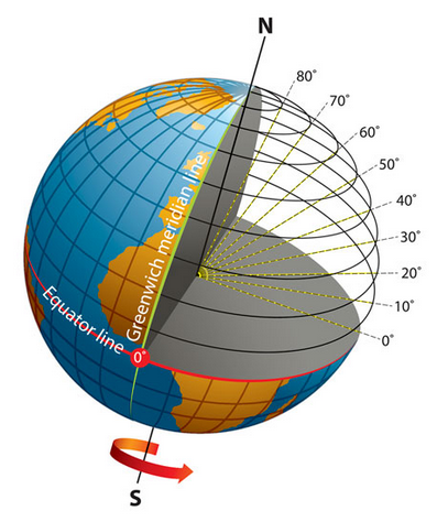
The Earth tilted on its axis, with the equator and Prime Meridian labeled [Source: oceanservice.noaa.gov]
A cutaway section reveals the horizontal latitude lines (parallels) north of the equator. Radial lines drawn from the Earth’s center to these parallels demonstrate that latitude is the angular measurement north or south of the equatorial plane. An arrow near the South Pole indicates the direction of rotation.
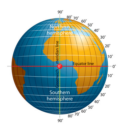
The Earth with its equator and Prime Meridian (Greenwich meridian) [Source: oceanservice.noaa.gov]
The globe is divided into the Northern Hemisphere, located above the equator, and the Southern Hemisphere, located below it. The latitude lines are marked from 90° North at the pole to 0° at the equator, and continuing to 90° South at the opposite pole.
More
Why Bi’r Hima in Saudi Arabia matters Bi’r Hima, located in southwestern Saudi Arabia, is indeed one of the most significant archaeological sites in the world, offering…
Places, with Latitude and Longitude, in Guma LGA, Benue State, Nigeria PLACELATITUDELONGITUDEAbinsi7.7502308.250732Achie I/Mbalisa8.0598408.672870Achie II8.1160208.702750Adagu7.9554808.860830Adasho8.1014708.401490Adawagi II8.0500208.363290Adoyem(Wombu)8.0361208.512300Agar7.8356508.734960Agasha7.7094008.865400Agben8.1476808.455910Agber8.0607608.675590Ahsuku Island7.8115408.926040Ajimnee (Mbayer II)8.1654138.624380Akulayem7.9321408.544250Akumba7.7337708.769990Ambutor8.0706508.681260Anbar8.4214308.421430Andyar-Mbachikiv7.7464409.040510Angbaaye7.7367108.704440Anuha Island I7.8058108.890700Anuha Island II7.8187508.868000Aondokume7.9272808.834330Awange8.0899008.502903Ayeri8.0661808.426110Ayia-Mbalortyon8.0497788.510610Ayokpe-Ujam7.9107908.711510Azom Utange7.7247008.813350Azyoko7.7529608.742690Beetse8.1165308.381950Benco Settlement7.7529208.736700Ber-Anyabe8.0610208.862890Buaka Aha Mbagbaav7.6785009.063690Cam Garba7.8717808.588240Chemberger-Ukum8.0627908.781700Chiaka I7.8723808.631320Chiaka II8.0997908.004740Dankye-Mbabun7.7468508.895480Daudu7.9058908.566790Gbabua8.0630208.990840Gbajimba7.8215808.854500Gbeleke Mbabun7.7597108.899300Gbenyam-Ngbianjor8.0042608.762970Ginde7.6783509.082060Guma/Mbatako II7.9920708.719760Hirnyam7.9830108.563580Hirw…
What are subsidies and why they matter There is no universally accepted definition of a subsidy. Organizations such as the Organisation for Economic Co-operation and Development (OECD)…
Why Study Zulu There are many reasons for studying Zulu, including personal interest in southern African cultures, research interests and fulfillment of foreign…


")


, Conversion, Maturity: Understanding Public Services Terms")


