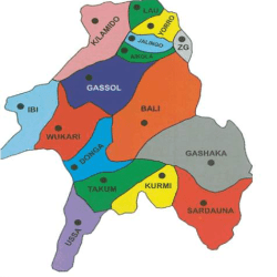
Taraba is divided into 16 Local Government Areas, including Ardo Kola, Bali, Donga, Gashaka, Gassol, Ibi, Jalingo, Karim Lamido, Kurmi, Lau, Sardauna, Takum, and others. Each LGA serves as an administrative unit that implements policies and development projects to cater to local needs.
Taraba Local Government Areas and the Council Wards are:
Ardo – Kola
Alim Gora
Ardo Kola
Iware
Jauro Yinu
Lamido Borno
Mayo Ranewo
Sarkin Dutse
Sunkani
Tau
Zongon Kombi
Bali
Badakoshi
Bali A
Bali B
Gang Dole
Gang Mata
Ganglari
Gangtiba
Kaigama
Maihula
Suntai
Takalafiya
Donga
Akate
Asibiti
Bikadarko
Fada
Gayama
Gindin Dutse
Gyatta Aure
Mararraba
Nyita
Suntai
Gashaka
Galumjina
Gangumi
Garbabi
Gashaka
Gayam
Jamtari
Mai-Idanu
Mayo Selbe
Serti ‘A’
Serti ‘B’
Gassol
Gassol
Gunduma
Mutum Biyu I
Mutum Biyu II
Nam Nai
Sabon Gida
Sarkin Shira
Sendirde
Tutare
Wurojam
Wuryo
Yarima
Ibi
Dampar I
Dampar II
Dampar III
Ibi Nwonyo I
Ibi Nwonyo II
Ibi Rimi Uku I
Ibi Rimi Uku II
Sarkin Kudu I
Sarkin Kudu II
Sarkin Kudu III
Jalingo
Abbare Yelwa
Barade
Kachalla Sembe
Kona
Majidadi
Mayo Goi
Sarkin Dawaki
Sintali
Turaki ‘A’
Turaki ‘B’
Karim-Lamido
Amar
Andamin
Bachama
Bikwin
Darofai
Didango
Jen Ardido
Jen Kaigama
Karim “A”
Karim “B”
Kwanchi
Kurmi
Abong
Akwento/Boko
Ashuku/Eneme
Baissa
Bente/Galea
Bissaula
Didan
Ndaforo/Geanda
Njuwande
Nyido/Tosso
Lau
Abbare I
Abbere II
Donadda
Garin Dogo
Garin Magaji
Jimlari
Kunini
Lau I
Lau II
Mayo Lope
Sardauna
Gembu ‘A’
Gembu ‘B’
Kabri
Kakara
Magu
Mayo-Ndaga
Mbamnga
Ndum-Yaji
Nguroje
Titong
Warwar
Takum
Bete
Bikashibila
Chanchanji
Dutse
Fete
Gahweton
Manya
Rogo
Shibong
Tikari
Yukuben
Ussa
Fikyu
Kpambo
Kpambo Puri
Kwesati
Lissam I
Lissam II
Lumbu
Rufu
Wukari
Akwana
Avyi
Bantaje
Chonku
Hospital
Jibu
Kente
Puje
Rafin Kada
Tsokundi
Yorro
Bikassa I
Bikassa II
Nyaja I
Nyaja II
Pantisawa I
Pantisawa II
Pupule I
Pupule II
Pupule III
Sumbu I
Sumbu II
Zing
Bitako
Bubong
Dinding
Lamma
Monkin A
Monkin B
Yakoko
Zing A I
Zing A II
Zing B
> List of Council Wards, Local Government Areas (LGAs) and States in Nigeria

Taraba State, known as “Nature’s Gift to the Nation,” is a state in northeastern Nigeria, created from the former Gongola State in 1991. Named after the Taraba River, the state is a picturesque region known for its rich cultural diversity, abundant natural resources, and scenic landscapes, with the capital situated in Jalingo. This article offers a comprehensive overview of Taraba State, including its geography, cultural heritage, economic activities, and key attractions.
Geographical Location and Boundaries
Located in northeastern Nigeria, Taraba State is bordered by Bauchi and Gombe to the north, Adamawa to the east, Cameroon to the south, and Benue, Nassarawa, and Plateau states to the west. The state’s position provides both cultural and economic linkages to neighboring regions and is strategically situated for trade and tourism.
History and Creation of Taraba State
Taraba State was established on August 27, 1991, under General Ibrahim Babangida’s administration, carved out of Gongola State to fulfill administrative and cultural aspirations. Named after the Taraba River, which flows through the region, the state has since developed its identity, rich in diversity and natural endowments.
Capital and Major Towns
Jalingo serves as the capital of Taraba, housing government institutions, businesses, and cultural centers. Other notable towns include Wukari, Serti, Takum, and Gembu, each contributing to the state’s vibrant cultural and economic landscape.
Demographics
Taraba is home to over 4 million people, with a unique mix of ethnic and linguistic diversity. While the population distribution is primarily rural, urban centers are growing, attracting people from various ethnic backgrounds due to the state’s economic opportunities and natural beauty.
Ethnic and Cultural Groups
The major ethnic groups in Taraba include the Mumuye, Jukun, Chamba, Tiv, Kuteb, and Ichen, predominantly found in the southern part of the state. The Wurkum, Mumuye, and Kona tribes are primarily concentrated in the northern areas. Each group maintains its distinct traditions while participating in the broader cultural fabric that defines Taraba State.
Languages and Cultural Identity
Taraba’s ethnic groups speak over 40 different languages, contributing to a rich cultural tapestry. The diversity of languages reflects the social and historical depth of the state’s communities, creating a unique cultural identity where traditions, music, and dance play significant roles in everyday life.
Topographical Features
One of Taraba’s standout geographical features is the Mambilla Plateau, a highland area that provides breathtaking views, lush vegetation, and cool temperatures. Additionally, the state’s terrain is characterized by mountainous regions, particularly around the Adamawa Plateau, which enhance its natural beauty and suitability for livestock farming.
Rivers and Waterways
The Benue and Taraba Rivers traverse the state, enabling river transport and supporting agriculture. These waterways also contribute to fishing, an essential part of the local economy, particularly in riverine communities.
Climate
Taraba experiences a tropical climate, with a rainy season from May to October and a dry season from November to April. The climate varies by altitude, with highland areas like the Mambilla Plateau enjoying cooler temperatures year-round, making it ideal for livestock farming and crop cultivation.
Agriculture
Agriculture is the primary occupation for many Taraba residents. Farmers in the state cultivate crops such as maize, millet, rice, yams, and cassava, with both subsistence and commercial farming practices prevalent. The southern part of Taraba is suitable for rubber and oil palm cultivation, while the Mambilla Plateau supports cattle grazing due to its tsetse fly-free highlands.
Natural Resources and Economic Activities
Beyond agriculture, Taraba boasts rich natural resources, including rubber and oil palm plantations. Cattle grazing, fishing, and forestry also contribute to the state’s economy. The Mambilla Plateau’s high-altitude grasslands are particularly suitable for cattle and sheep, providing significant economic value.
Tourism and Attractions
Taraba’s natural beauty is a major draw for tourism. The Mambilla Plateau offers scenic landscapes and cool weather, ideal for vacations and outdoor adventures. The Gashaka-Gumti National Park, one of Nigeria’s largest and most biodiverse reserves, houses various wildlife species, attracting tourists and conservationists alike. Other popular sites include the Nwunyu Fishing Festival in Ibi, the Mambilla Tourist Center, and Gumpti Park.
Festivals and Cultural Celebrations
Taraba celebrates several annual festivals that showcase its rich cultural heritage. Key events include the Nwunyu Fishing Festival in Ibi, the Purma festival of the Chamba people in Donga, the Kuchecheb festival of the Kuteb people in Takum, and the Kati festival of the Mambilla people. These events feature traditional dances, canoe racing, and cultural displays that bring communities together and attract visitors.
Infrastructure and Transport
Taraba has a developing infrastructure network with roads linking Jalingo to Yola in Adamawa, Bauchi to the north, and Makurdi to the south. The state’s road network is crucial for transporting agricultural products, linking rural areas to markets, and fostering economic growth.
Energy and Industrial Development
The Mambilla Hydro-electric Power Project is one of Nigeria’s largest energy projects, located on the Mambilla Plateau. Once completed, this project is expected to generate significant electricity, benefiting Taraba and neighboring states while supporting industrial and economic development.
- What is the capital of Taraba State?
- Jalingo is the capital of Taraba State, serving as the administrative and commercial center.
- What are the major ethnic groups in Taraba?
- Taraba is home to diverse ethnic groups, including the Mumuye, Jukun, Chamba, Tiv, Kuteb, Ichen, Kona, and Wurkum, each contributing to the state’s rich cultural heritage.
- What is the Mambilla Plateau known for?
- The Mambilla Plateau is famous for its scenic beauty, cool climate, and suitability for agriculture, particularly cattle grazing and tea cultivation.
- What are Taraba’s main economic activities?
- Agriculture is the backbone of Taraba’s economy, with significant contributions from crop cultivation, livestock farming, fishing, and natural resources such as rubber and oil palm.
- What festivals are celebrated in Taraba State?
- Taraba hosts several festivals, including the Nwunyu Fishing Festival, Purma of the Chamba, Kuchecheb of the Kuteb, and the Kati of the Mambilla, celebrating the state’s rich cultural traditions.
- What is the Mambilla Hydro-electric Power Project?
- Located on the Mambilla Plateau, this project aims to generate hydroelectric power, supporting energy needs across Taraba and surrounding states.


