Longitude Explained: From the Prime Meridian to GPS Satellites
Longitude lines, the prime meridian, the international date line, and how GPS satellites help us measure longitude with extreme accuracy.
What is Longitude?
Longitude lines, also called meridians, are imaginary lines running north to south from the North Pole to the South Pole. Unlike latitude (which measures north and south of the equator), longitude measures east and west of the prime meridian (0° longitude).
Longitude is measured in degrees (°), minutes (‘), and seconds (“), ranging from 0° at Greenwich, England to 180° east and west, where it meets at the antimeridian.
Prime Meridian and Antimeridian
Prime Meridian (0° longitude): Runs through Greenwich, England, dividing Earth into the Eastern and Western Hemispheres.
Antimeridian (180° longitude): Located on the opposite side of the Earth. It forms the basis of the International Date Line, although the date line zigzags to avoid splitting countries and islands.
How Longitude Works
Unlike latitude lines, longitude lines are not evenly spaced:
At the equator, one degree of longitude equals about 111 km (69 miles).
At 60° north or south, it narrows to about 56 km (35 miles).
At the poles (90° N/S), all longitude lines converge, so the distance between them is zero.
The Longitude Problem: A History of Navigation
For centuries, sailors could measure latitude using the sun or stars, but longitude was much harder to calculate. Inaccuracies at sea often led to shipwrecks.
In the 16th century, European governments offered huge rewards to anyone who could solve “the longitude problem.”
The breakthrough came in the 18th century with the invention of marine chronometers — precise clocks that worked reliably at sea.
Navigators compared local noon (when the sun was highest) with the time at Greenwich Mean Time (GMT) on their chronometer.
Since Earth rotates 15° per hour, every hour of time difference = 15° of longitude.
This innovation revolutionized navigation, making global exploration and trade far safer.
Longitude in the Modern Era: GPS and Satellites
Today, longitude is measured with incredible accuracy using Global Positioning System (GPS) satellites.
Each satellite carries atomic clocks accurate to within 40 nanoseconds.
They broadcast precise radio signals that travel at the speed of light.
By measuring how long the signal takes to reach a GPS receiver, longitude (and latitude) can be calculated.
On the ground, NOAA’s Continuously Operating Reference Stations (CORS) Network refines GPS data. While a smartphone GPS is accurate within 5 meters, processed CORS data can pinpoint longitude within a few centimeters.
Prime Meridian vs. International Reference Meridian
Unlike the equator, which is fixed halfway between the poles, the prime meridian is arbitrary.
In 1884, the International Meridian Conference in Washington, D.C., chose Greenwich as the 0° longitude line.
But due to Earth’s irregular shape and gravity variations, the GPS-calculated line does not perfectly align with the original Greenwich marker.
In fact, your GPS will read 0° longitude about 102 meters east of the historic Royal Observatory line.
To solve this, the International Reference Meridian (IRM) was established in the 1980s as a scientifically precise 0° longitude line. Unlike the fixed Greenwich meridian, the IRM shifts slightly over time as Earth’s crust moves.
Key Takeaways
Longitude measures east-west of the Prime Meridian.
The Prime Meridian (0°) runs through Greenwich, England; the Antimeridian (180°) is opposite.
The International Date Line is based on 180°, but zigzags for political and practical reasons.
Accurate longitude measurement was solved in the 18th century with marine chronometers.
Today, GPS satellites and atomic clocks provide longitude accuracy to within centimeters.
Longitude has evolved from a deadly navigational mystery to a precision science, shaping everything from global shipping routes to the smartphone in your pocket.
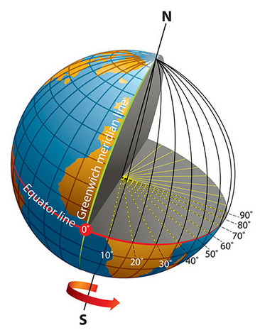
Earth at a tilt. The equator and the Prime Meridian in Greenwich [Source: oceanservice.noaa.gov]
This diagram depicts the Earth at a tilt, highlighting its geographic grid. The equator and the Prime Meridian in Greenwich are clearly marked. To illustrate how longitude is measured, a portion of the globe is removed to show the meridians—lines running from pole to pole—for 0° to 90° east. Radial lines extending from the planet’s center to these meridians visually represent longitude as a central angle. The Earth’s rotational direction is shown with an arrow near the South Pole.
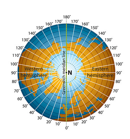
Polar view of the Earth, centered on the North Pole [Source: oceanservice.noaa.gov]
This image presents a unique polar view of the Earth, centered on the North Pole. The Greenwich meridian (0° longitude) runs vertically from the center to the bottom, while the antimeridian (180°) runs from the center to the top. This layout divides the planet into two halves: the Western Hemisphere on the left and the Eastern Hemisphere on the right. Longitude lines are marked in both directions, from 0° to 180° West on the left and 0° to 180° East on the right.
More
Places, with Latitude and Longitude, in Guma LGA, Benue State, Nigeria PLACELATITUDELONGITUDEAbinsi7.7502308.250732Achie I/Mbalisa8.0598408.672870Achie II8.1160208.702750Adagu7.9554808.860830Adasho8.1014708.401490Adawagi II8.0500208.363290Adoyem(Wombu)8.0361208.512300Agar7.8356508.734960Agasha7.7094008.865400Agben8.1476808.455910Agber8.0607608.675590Ahsuku Island7.8115408.926040Ajimnee (Mbayer II)8.1654138.624380Akulayem7.9321408.544250Akumba7.7337708.769990Ambutor8.0706508.681260Anbar8.4214308.421430Andyar-Mbachikiv7.7464409.040510Angbaaye7.7367108.704440Anuha Island I7.8058108.890700Anuha Island II7.8187508.868000Aondokume7.9272808.834330Awange8.0899008.502903Ayeri8.0661808.426110Ayia-Mbalortyon8.0497788.510610Ayokpe-Ujam7.9107908.711510Azom Utange7.7247008.813350Azyoko7.7529608.742690Beetse8.1165308.381950Benco Settlement7.7529208.736700Ber-Anyabe8.0610208.862890Buaka Aha Mbagbaav7.6785009.063690Cam Garba7.8717808.588240Chemberger-Ukum8.0627908.781700Chiaka I7.8723808.631320Chiaka II8.0997908.004740Dankye-Mbabun7.7468508.895480Daudu7.9058908.566790Gbabua8.0630208.990840Gbajimba7.8215808.854500Gbeleke Mbabun7.7597108.899300Gbenyam-Ngbianjor8.0042608.762970Ginde7.6783509.082060Guma/Mbatako II7.9920708.719760Hirnyam7.9830108.563580Hirw…


 in Algeria")


