Using Live Video From Drones, GPS, and Satellite Imagery to Locate People in the Bush
By combining live drone video, GPS positioning, and satellite intelligence, search teams can significantly reduce search times, improve situational awareness, and increase the chances of finding missing individuals alive.
Understanding the Three Technologies
Although drones, GPS, and satellite imagery are often discussed together, each serves a different purpose during a rescue operation.
GPS Provides Precise Location Data
Global Positioning System (GPS) technology determines a person’s location using signals from satellites orbiting Earth. If a lost person has a smartphone, GPS tracker, satellite communicator, emergency beacon, or vehicle tracking device, rescuers may be able to obtain accurate coordinates.
GPS allows search teams to:
Identify the last known location.
Track movement patterns.
Establish a search area.
Guide rescuers directly to a target location.
Coordinate multiple search teams.
When available, GPS data often becomes the foundation of the entire rescue operation.
Satellite Imagery Provides Terrain Intelligence
Satellite imagery offers a bird’s-eye view of the search area. While satellites generally cannot provide continuous live video of every location on Earth, they can provide valuable geographic information that helps rescuers understand the environment.
Satellite imagery can reveal:
Forest density.
Rivers and streams.
Roads and footpaths.
Open clearings.
Mountains and valleys.
Swamps and wetlands.
Buildings and settlements.
Rescuers use this information to determine where a missing person is likely to travel and identify the safest routes for search teams. Satellite mapping is also useful for estimating travel times and identifying obstacles before personnel enter the field.
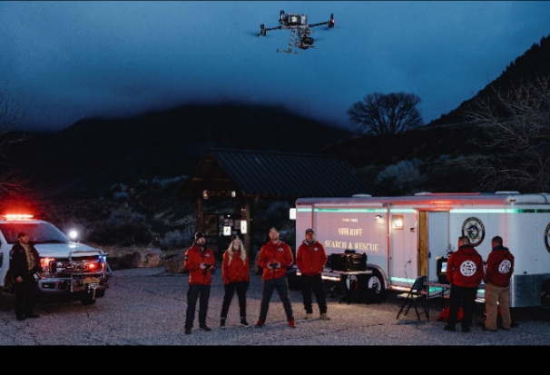
Drones Deliver Real-Time Visual Information
Drones bridge the gap between GPS coordinates and satellite imagery by providing live aerial video directly from the search area.
Unlike satellites, drones can fly at low altitudes and capture detailed real-time footage. Search teams can monitor live video feeds, zoom into areas of interest, and quickly investigate locations that would take hours to reach on foot.
Modern search-and-rescue drones may carry:
High-definition cameras.
Thermal imaging cameras.
Infrared sensors.
Night-vision systems.
Loudspeakers.
Searchlights.
Research and operational experience show that drones can reduce search times, improve safety for rescuers, and provide cost-effective aerial coverage of large wilderness areas.
Step 1: Establish the Search Area Using GPS
The first objective in any bush rescue is determining where to begin searching.
If the missing person has transmitted GPS coordinates through a smartphone, emergency beacon, satellite messenger, or tracking device, rescuers can immediately focus resources on a specific location rather than searching blindly.
Even partial GPS information can help.
For example, rescuers may obtain:
Last known coordinates.
Recent travel direction.
Speed of movement.
Time of the last recorded signal.
This information allows search coordinators to estimate where the individual may be located and prioritize high-probability search zones.
Step 2: Analyze Satellite Imagery
Once a search area has been identified, rescuers examine satellite imagery to understand the surrounding terrain.
Satellite maps help answer critical questions:
Are there nearby roads?
Is there a water source the person may have followed?
Are there dangerous cliffs or ravines?
Are there open areas suitable for helicopter landing?
Which routes are easiest for ground teams?
People lost in the bush often move toward recognizable landscape features such as roads, rivers, or clearings. Satellite imagery helps predict likely travel patterns and narrow the search area.
Step 3: Deploy Drones for Live Video Surveillance
After establishing a probable search zone, drones are launched to gather real-time visual information.
Drone operators typically fly systematic search patterns designed to maximize coverage while minimizing overlap.
Common search patterns include:
Grid searches.
Parallel sweeps.
Expanding square searches.
Sector searches.
Terrain-following routes.
Drones can cover large areas much faster than ground teams, especially in locations where thick vegetation, steep slopes, marshes, or rivers slow human movement.
Step 4: Use Thermal Imaging to Detect Heat Signatures
One of the most effective drone technologies for bush rescues is thermal imaging.
Thermal cameras detect heat rather than visible light, making them useful during:
Night operations.
Low-light conditions.
Dense vegetation gaps.
Cold-weather searches.
A person’s body heat often appears as a bright thermal signature against cooler surroundings. Numerous rescue operations have successfully used thermal drones to locate missing individuals hidden in forests and brush.
Thermal imaging can be particularly valuable when:
The individual is unconscious.
The person is sheltering under vegetation.
Visibility is limited.
Searches continue after sunset.
Step 5: Integrate Live Drone Video With GPS Coordinates
Modern search operations combine live drone video with GPS mapping systems.
As the drone flies, its camera feed is linked to geographic coordinates. When an operator spots a possible person, the exact location can be marked immediately.
This process allows rescue coordinators to:
Pinpoint targets.
Dispatch ground teams.
Track search coverage.
Eliminate already searched areas.
Coordinate multiple response units.
Georeferenced drone imagery has become an increasingly important tool because it allows teams to document precisely which areas have been searched.
Step 6: Use Artificial Intelligence to Analyze Drone Footage
Large search operations can generate thousands of aerial images and hours of video footage.
Artificial intelligence systems are increasingly being used to scan drone imagery for:
Human shapes.
Clothing colors.
Movement patterns.
Heat signatures.
Unusual visual anomalies.
AI-assisted analysis can help search teams process large volumes of imagery far more quickly than manual review alone. Recent field applications have demonstrated the value of combining drone imagery with automated image analysis to locate missing persons in difficult terrain.
Step 7: Guide Ground Teams to the Target
Once a potential sighting is confirmed, the drone becomes a real-time guidance platform.
Operators can:
Track the person’s movement.
Direct rescuers around obstacles.
Monitor hazards.
Identify the safest approach route.
Maintain visual contact until ground teams arrive.
Best Practices for Bush Search Operations
The most effective rescues typically combine all available technologies.
A recommended workflow includes:
Obtain GPS coordinates or last known location.
Analyze satellite imagery to understand terrain.
Identify high-probability search zones.
Deploy drones with live video and thermal imaging.
Use AI-assisted image analysis when available.
Mark potential sightings with GPS coordinates.
Dispatch ground teams.
Maintain aerial overwatch until extraction is complete.
This layered approach maximizes search efficiency while reducing risks to rescuers and improving the chances of locating missing individuals quickly.
The combination of GPS positioning, satellite imagery, and live drone video has revolutionized wilderness search and rescue. GPS provides accurate location data, satellite imagery delivers critical terrain intelligence, and drones supply real-time aerial surveillance that can dramatically accelerate search efforts.
When integrated into a coordinated rescue strategy, these technologies allow search teams to cover more ground, make better decisions, and locate missing people in the bush faster than ever before. As drone sensors, satellite capabilities, and artificial intelligence continue to evolve, the effectiveness of technology-assisted rescue operations will only continue to improve, helping save lives in some of the world’s most challenging environments.
Etulo People’s Fishing and Pot Building Heritage Etulo people have ancestral roots across both Katsina-Ala and Buruku Local Government Areas. They occupied these lands for generations, building…
Baatonu People and the Kingdom of Borgu The documented history of the Baatonu people, also known as the Baatombu or Bariba, begins with their integral role in…
Borno People and Languages With a rich but diverse historical and cultural heritage, Borno State is pluralistic in ethnic composition. About thirty languages are…
Enugu: The place and the people The Place GeographyEnugu State is one of the States in the South Eastern part of Nigeria. The state shares borders…
Etulo People of Nigeria The Etulo people are a minority ethnic group in central Nigeria, primarily found in Benue State, especially around Buruku and…


 Community in Warri North Local Government Area, Delta State: A People at the Crossroads of Rich Heritage and Existential Challenges")


