Kogi State was carved out of the old Kwara and Benue States. The birth of the new State was a reunion of a people who had shared a common history and had co-existed as one polity for decades before being severed by the 1976 States creation exercise.
The State was created on the 27th August 1991 by the administration of former President Ibrahim Babangida.
The area which today forms Kogi State was in the colonial period known as Kabba Province which suffered neglect since independence. It was the quest for rapid socio-economic development of the area that informed the decision of the government in 1991 to create along with eight others, a State out of both Kwara and Benue bringing together families who had been separated by the 1976 states creation exercise into a happy reunion.
Kogi State is made up of the Igala, Kabba, Ebira and Kogi Division of the former Kabba Province. It is the most centrally located State in the country and shares boundaries with the Plateau, Niger and the Federal Capital Territory (FCT), to the North, Benue and the Anambra States to the East and on the West, it is bordered by Ondo, Kwara, Edo and Enugu States. It is in short, the gateway State with very rich cultural values, great natural endowments and infinite stretches of arable land.
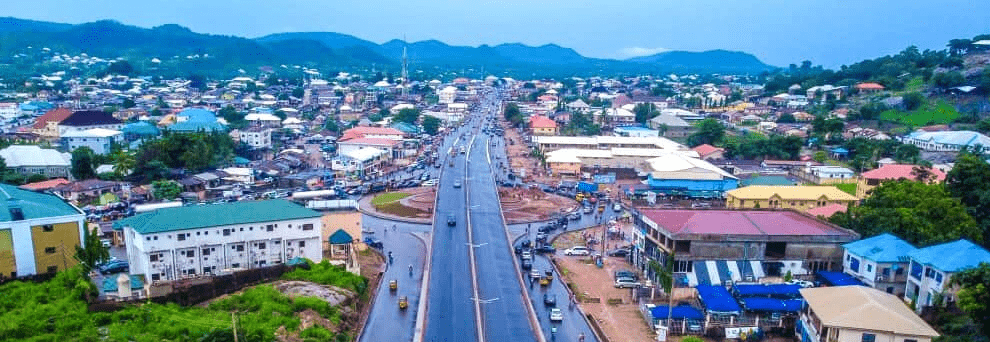
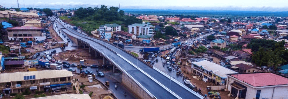
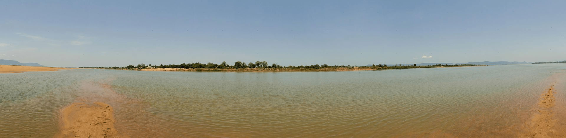
The state capital, Lokoja is an ancient historical town which once served as the colonial administrative headquarters of Nigeria. It is located on the intersecting point of longitude 70 49’N and latitude 60 44’E on the map of Nigeria. Lokoja town is situated on the slope of a range of hills, Mount Patti. The town in its growth runs down the scope and expands into the Niger River valley. It is located at the confluence of the rivers Niger and Benue. The Kogi State Capital, fast turning into a modern city is bounded on the North and East by the River Niger and on the West by the wooded heights of Mount Patti and South by Ajaokuta. It occupies an area of between twenty and thirty kilometers. The state capital, like most others in the country, plays a dual role since it is the administrative headquarters of the Kogi Local Government Area.
In spite of the difficulties in the definition of the Niger-Benue confluence area, there seems to be a general agreement on the various peoples and cultures that inhabit the areas which now form Kogi State. The peopling of the area has been studied in the context of evidence derived from archaeology, physical anthropology, and historical linguistics. It has in this area dates back to the Stone Age.
Lokoja now wears the necessary paraphernalia of a state capital: Government House, State Secretariat, Federal establishments, institutions of higher learning, stadia, industries, increased population and a number of other attributes of a state capital.
More on Kogi
Kogi State is one of the 36 states of Nigeria, located in the north-central region of the country.
Coat of armsFlag
It is home to the confluence of the Niger and Benue rivers which form the largest inland delta in Africa. It is also blessed with diverse mineral deposits, such as coal, iron ore, limestone, gold, and kaolin.
Lokoja, the capital of Kogi State
It was created in 1991 from parts of Kwara State and Benue State, and it is bordered by Niger, Federal Capital Territory, Nassarawa, Benue, Enugu, Anambra, Edo, Ondo, Ekiti, Kwara and Niger states.
The state capital is Lokoja, which is also the confluence of the Niger and Benue rivers, making it a historically significant location for trade and commerce.
It has a population of about 4.5 million people, according to the 2006 census, and it is ethnically diverse with over 50 indigenous groups, including Igala, Ebira, Okun, Bassa, Nupe and others.
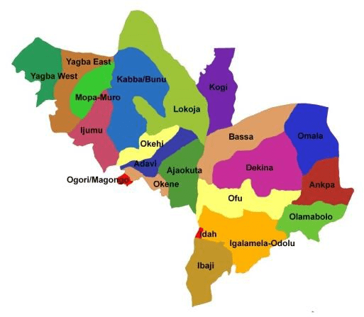
Kogi is divided into 21 local government areas (LGAs), and it has three senatorial districts: Kogi East, Kogi West and Kogi Central.
List of 21 Local Government Areas in Kogi State
Adavi
Ajaokuta
Ankpa
Bassa
Dekina
Ibaji
Idah
Igalamela-Odolu
Ijumu
Kabba/Bunu
Kogi
Lokoja
Mopa-Muro
Ofu
Ogori/Mangongo
Okehi
Okene
Olamabolo
Omala
Yagba East
Yagba West
Map of Kogi State Local Government Areas
Tourist attractions include Lord Lugard Residence, the Mount Patti Hill, the Confluence Beach Park, the Awo Tunnel, the Ogidi-Ijumu Rock Formation and the Iron of Liberty Monument.
The state is known for its cultural diversity and festivals such as the Igala Cultural Festival, the Ebira Carnival, the Okun Day Celebration and the Bassa Nge Festival.
Kogi festivals include the Igala Masquerade Festival and the Ebira Carnival.
The Igala Masquerade Festival is an annual event that showcases the rich traditions and costumes of the Igala people. The festival features different types of masquerades that represent different aspects of Igala culture and mythology.
The Ebira Carnival is another colorful celebration that involves music, dance, and art. The carnival showcases the creativity and talent of the Ebira people, who are known for their pottery, weaving, and carving skills.
Kogi is a state that offers a lot of opportunities for adventure, learning, and fun. It is a place where you can experience the beauty and diversity of Nigeria’s culture and nature.
List of Local Government Areas in Kogi State and their headquarters Kogi State Local Government Areas and their headquarters, administrative capitals are: LGAHeadquartersAdaviOgaminanaAjaokutaEgayanAnkpaAnkpaBassaOgumaDekinaDekinaIbajiOnyedegaIdahIdahIjumuIyaraIgalamela-OdoluAjakaKabba/BunuKabbaKogiKoton KarfeLokojaLokojaMopa-MuroMopaOlamaboloOkpoOfuOgwoawoOkehiOkehiOmalaAbejukoloOgori/MagongoAkpafaOkeneOkeneYagba EastIsanluYagba WestOdo Ere Map of Kogi State…
Largest Local Government Areas in Kogi State by land area 10 largest Local Government Areas by land area in Kogi State of Nigeria are: LokojaKabba/BunuDekinaIgalamela-OdoluBassaOfuOmalaKogiYagba EastIbaji LARGE. List of LGAs in…
LGA in Kogi State The LGAs (Local Government Areas) in Kogi State, Nigeria are: Adavi Ajaokuta Ankpa Bassa Dekina Ibaji Idah Igalamela-Odolu Ijumu Kabba/Bunu…
Markets in Kogi State Kogi State markets according to Local Government Areas are: Ankpa Local Government AreaA. Ankpa MarketB. Afogamgam MarketC. Okaba Market Omala…
List of markets in Kogi State Markets in Kogi State by Local Government Areas are: Ankpa Local Government AreaA. Ankpa MarketB. Afogamgam MarketC. Okaba Market Omala…
History of Kogi State Kogi State was carved out of the old Kwara and Benue States. The people f Kogi had shared a common…
Kogi State NYSC orientation camp address The address of the NYSC orientation camp in Kogi State is: NYSC Permanent Orientation Camp, Asaya, Kabba Local Government Area,…
Kogi Local Government Areas and their headquarters Local Government Areas and their headquarters in Kogi State, Nigeria LGAHeadquartersAdaviOgaminanaAjaokutaEgayanAnkpaAnkpaBassaOgumaDekinaDekinaIbajiOnyedegaIdahIdahIjumuIyaraIgalamela-OdoluAjakaKabba/BunuKabbaKogiKoton KarfeLokojaLokojaMopa-MuroMopaOlamaboloOkpoOfuOgwoawoOkehiOkehiOmalaAbejukoloOgori/MagongoAkpafaOkeneOkeneYagba EastIsanluYagba WestOdo Ere Kogi Kogi State is one…
KOGI ETHNIC COMPOSITION Kogi State is highly heterogeneous and Its central location coupled with the diverse states and ethnic groups surrounding it. The…
List of Kogi federal constituencies Kogi State consists of nine federal constituencies as follows: Oken/Ogori-Magongo Ajaokuta Okehi/Adavi Kabba-bunu/Ijumu Yagba Lokoja/Koton-karfi Idah/Igala-mela/Ofu Dekina/Bassa Ankpa/Omala/Olamaboro Kogi also…
Kogi Political Structure Kogi State consists of three senatorial districts, namely: Kogi Western Senatorial District Kogi Central Senatorial District Kogi Eastern Senatorial District…
List of Kogi senatorial districts Kogi State consists of three senatorial districts, namely: Kogi Western Senatorial District Kogi Central Senatorial District Kogi Eastern Senatorial District…
GIFMIS Code for FEDERAL MEDICAL CENTRE, KOGI The GIFMIS Codes for FEDERAL MEDICAL CENTRE, KOGI are: SNREVENUE NUMBERREVENUE ITEM DESCRIPTION11000060858CLINICAL21000060887X RAY FEE31000060832DRUGS41000060845X_RAY Reference: gifmis.gov.ng/grr-number/ GIFMIS Government Integrated…