It is located on the southern coast at the Gulf of Guinea, which is part of the Atlantic Ocean.
As of 2021 census, the Accra Metropolitan District, 20.4 km2 (7.9 sq mi), had a population of 284,124 inhabitants, and the larger Greater Accra Region, 3,245 km2 (1,253 sq mi), had a population of 5,455,692 inhabitants.
In common usage, the name “Accra” often refers to the territory of the Accra Metropolitan District as it existed before 2008, when it covered 199.4 km2 (77.0 sq mi).
This territory has since been split into 13 local government districts: 12 independent municipal districts (total area: 179.0 km2) and the reduced Accra Metropolitan District (20.4 km2), which is the only district within the capital to be granted city status.
This territory of 199.4 km2 contained 1,782,150 inhabitants at the 2021 census, and serves as the capital of Ghana, while the district under the jurisdiction of the Accra Metropolitan Assembly proper (20.4 km2) is distinguished from the rest of the capital as the “City of Accra”.
Formed from the merger of distinct settlements around British Fort James, Dutch Fort Crêvecoeur (Ussher Fort), and Danish Fort Christiansborg as Jamestown, Usshertown, and Christiansborg respectively, Accra served as the capital of the British Gold Coast between 1877 and 1957 and has since transitioned into a modern metropolis.
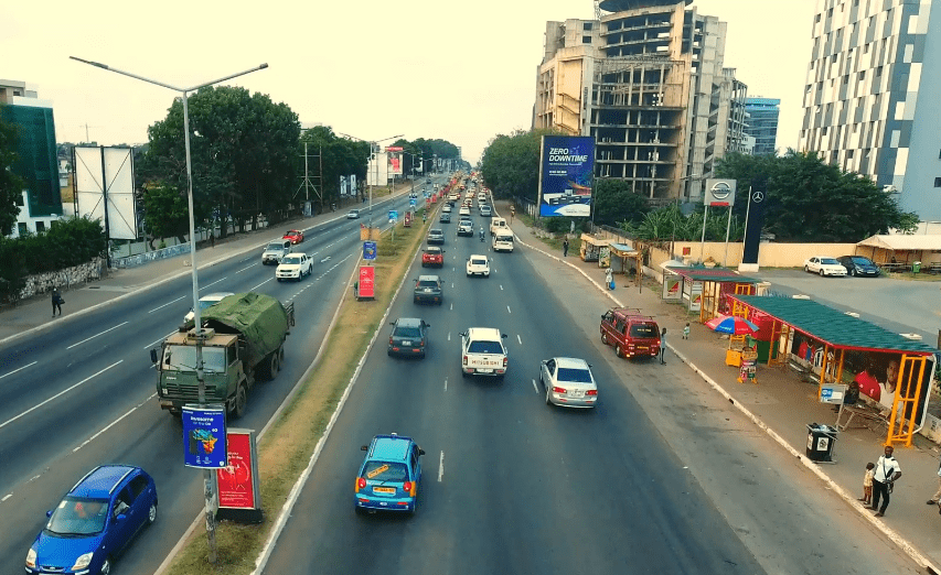
The capital’s architecture reflects this history, ranging from 19th-century colonial architecture to modern skyscrapers and apartment blocks.
Accra is the Greater Accra Region’s economic and administrative hub, and serves as the anchor of the larger Greater Accra Metropolitan Area (GAMA) which is inhabited by about 4 million people, making it the thirteenth-largest metropolitan area in Africa.
Accra districts
Accra Metropolitan District (City of Accra)
The Accra Metropolitan District is one of the 13 local government districts that contains the historic center and the primary central business district (CBD) of Accra. To promote efficiency in the administrative machinery and also meet the ever-pressing demands for amenities and essential services, the district is divided into the Ashiedu Keteke, Okaikoi South, and Ablekuma South sub-metropolitan districts.
The Accra Metropolitan Assembly, which governs the City of Accra within the boundaries of the Accra Metropolitan District, is led by a Metropolitan Chief Executive who is appointed by the President of the Republic of Ghana. The Mayor of Accra is Mohammed Adjei Sowah, who was appointed by President Nana Akufo-Addo and approved unanimously by the AMA on 23 March 2017.
The Ablekuma South sub-metropolitan district covers an area of 6 km2 (2.3 sq mi) and is bordered by the Ablekuma Central and Ablekuma North Municipal Assemblies, and the Ashiedu Keteke sub-metropolitan district. It includes 5 electoral areas: Korle Gonno, Korlebu, Chorkor, Mamprobi, and New Mamprobi.
Communities within the Okaikoi South sub-metropolitan district include Darkuman, New Fadama, Kaneshie, Bubiashie, and Avenor. The sub-metro has 8 electoral areas namely Awudome, Goten, Kaatsean, Mukose, Bubuashie, Bubui, Avenor and Kaneshie.
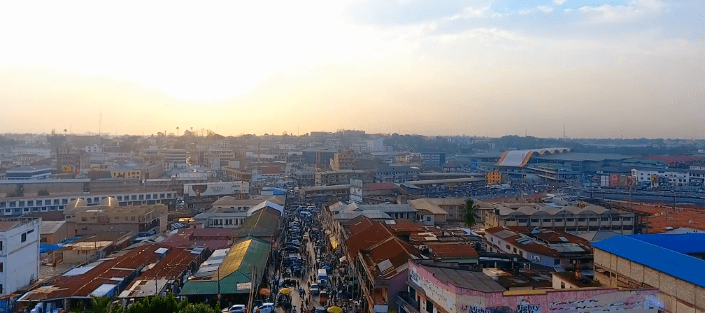
The Ashiedu Keteke sub-metropolitan district covers the Central Business District (CBD) and as such the hub of major commercial activities within the Metropolis. Major markets include Makola, Agbogbloshie, and Kwasiodwaso. There are 8 electoral areas namely Ngleshie, Mudor, Kinka, Nmlitsagonno, Amamomo, Korle Wonkon, and Korle Dudor.
Ledzekuku Municipal District
The Ledzekuku Municipal District, with its administrative capital at Teshie, covers an estimated area of 31.3 km2 (12.1 sq mi).
Krowor Municipal District
The Krowor Municipal District was carved out of the Ledzokuku-Krowor Municipal District in 2018. Its administrative capital is Nungua.
La Dadekotopon Municipal District
The La Dadekotopon Municipal District, with its administrative capital at La, was carved out of the Accra Metropolitan District in 2012. The Kotoka International Airport, Airport City, Accra Mall, and the US Embassy are located within the district, which covers an area of 32 km2 (12 sq mi). Other communities within this district include Cantonments, Labone, and Burma Camp.
Ablekuma North Municipal District
The Ablekuma North Municipal District was carved out of the Accra Metropolitan District in 2018 with an administrative capital at Darkuman Kokompe.
Ablekuma Central Municipal District
The Ablekuma Central Municipal District covers a total land area of 8.8 km2 (3.4 sq mi). Its administrative capital is Lartebiokorshie.
Ablekuma West Municipal District
The Ablekuma West Municipal District was carved out of the Accra Metropolitan District in 2018 and its administrative capital is Dansoman.
Ayawaso East Municipal District
The Ayawaso East Municipal District was carved out of the Accra Metropolitan District in 2018 and its administrative capital is Nima.
Ayawaso North Municipal District
The Ayawaso North Municipal District was carved out of the Accra Metropolitan District in 2018 and its administrative capital is Accra Newtown.
Ayawaso Central Municipal District
The Ayawaso Central Municipal District was carved out of the Accra Metropolitan District with an administrative capital being Kokomlemle.
Ayawaso West Municipal District
The Ayawaso West Municipal District was carved out of the Accra Metropolitan District and its administrative capital is Dzorwulu.
Okaikwei North Municipal District
Korley Kottey Municipal District
The Korley Klottey Municipal District was carved out of the Accra Metropolitan District in 2019 and covers an area of 10 km2 (3.9 sq mi) Some of the communities within the district include Osu, Ringway Estates, Asylum Down, North Ridge, West Ridge, Ministries, Gold Coast City, North Adabraka, and Tudu. There are 9 electoral areas namely Osu Doku, Ringway Estates, Kinkawe, Osu Alata, Asylum Down, North Adabraka, Tudu, Odorna/Sahara, and Official Town.
History of Accra
Initially, Accra was not the most prominent trading centre; the trade hubs of the time were the ports at Ada and Prampram, along with the inland centres of Dodowa and Akuse.
The Dutch built the nearby outposts of Ussher Fort while the British and the Swedes built James Fort and Christiansborg castles, respectively.
By the 17th century, Portugal, France and Denmark, had constructed forts in the city.
Britain gradually acquired the interests of all other countries beginning in 1851, when Denmark sold Christiansborg (which they had acquired from the Swedes) and their other forts to the British.
The Netherlands was the last to sell out, in 1871.
In 1873, after decades of tension between the British and Ashantis, the British captured Kumasi, destroying portions of the city.
The British then captured Accra in 1874, and in 1877, at the end of the second Anglo-Asante War, Accra replaced Cape Coast as the capital of the British Gold Coast.
This decision was made because Accra had a drier climate relative to Cape Coast. Until this time, the settlement of Accra was confined between Ussher Fort to the east and the Korle Lagoon to the west.
As the newly established Gold Coast’s administrative functions were moved to Accra (1877), an influx of British colonial administrators and European settlers grew around the Christiansborg (modern Osu, Ministries, Ridge, Labone, and Cantonments) began, and the city began to expand to accommodate the new residents.
Victoriaborg was formed in the late 19th century as an exclusively European residential neighborhood, located to the east of the city limits of the time.
The boundaries of Accra were further stretched in 1908. This expansion entailed the creation of a native-only neighborhood, intended to accommodate members of the native population as a means of relieving congestion problems in the overcrowded city center. Adabraka was thus established to the north of the city.
One of the most influential decisions in the history of the city was that of building the Accra-Kumasi railway in 1908.
This was to connect Accra, the country’s foremost port at that time, with Ghana’s main cocoa-producing regions. In 1923, the railway was completed, and by 1924, cocoa was Ghana’s largest export.
The colonial era heavily influenced the shape that Accra took during this period. For example, the segregation of European and African neighborhoods was mandated by law until 1923, and all new buildings were required to be built out of stone or concrete. Despite these regulations, European settlers in the Gold Coast were very hesitant to invest any large amount of money into the city to maintain its infrastructure or improve public works. This did not change until the governorship of Sir Frederick Gordon Guggisberg during which period the three separate settlements (Osu, La and Jamestown) merged to become modern Accra. Guggisberg’s administration laid out the present grid networked neighborhoods of Tudu, Adabraka and Asylum Down.
Among the achievements of Guggisberg was the building of a bridge across the Korle Lagoon in 1923, which opened the land west of the lagoon for settlement. Guggisberg also oversaw the building of a major hospital (Korle-Bu) and secondary school (Achimota). Such improvements led to an increase in Accra’s population due to the migration of rural dwellers into the city, and the immigration of increasing numbers of British businessmen and administrators.
More
Meaning of Accra The word Accra is derived from the Akan word Nkran meaning “ants”, a reference to the numerous anthills seen in…
Universities in Accra Central University Central University, Accra. It was founded by the International Central Gospel Church (ICGC) in Accra, Ghana University of…
Accra Districts Accra Metropolitan District (City of Accra) The Accra Metropolitan District is one of the 13 local government districts that contains…
Accra College of Education Accra College of Education (AcCE) trains and orients competent and professional student teachers of high Calibre for basic schools in…