Austria States Profiles: Capitals, Area, Population, Highlights
Profiles of each of the nine federal states (Länder) of Austria, including the number of districts, municipalities, major economic sectors and notable features. I’ll also include a map-based breakdown of how the districts and municipalities are distributed across Austria.
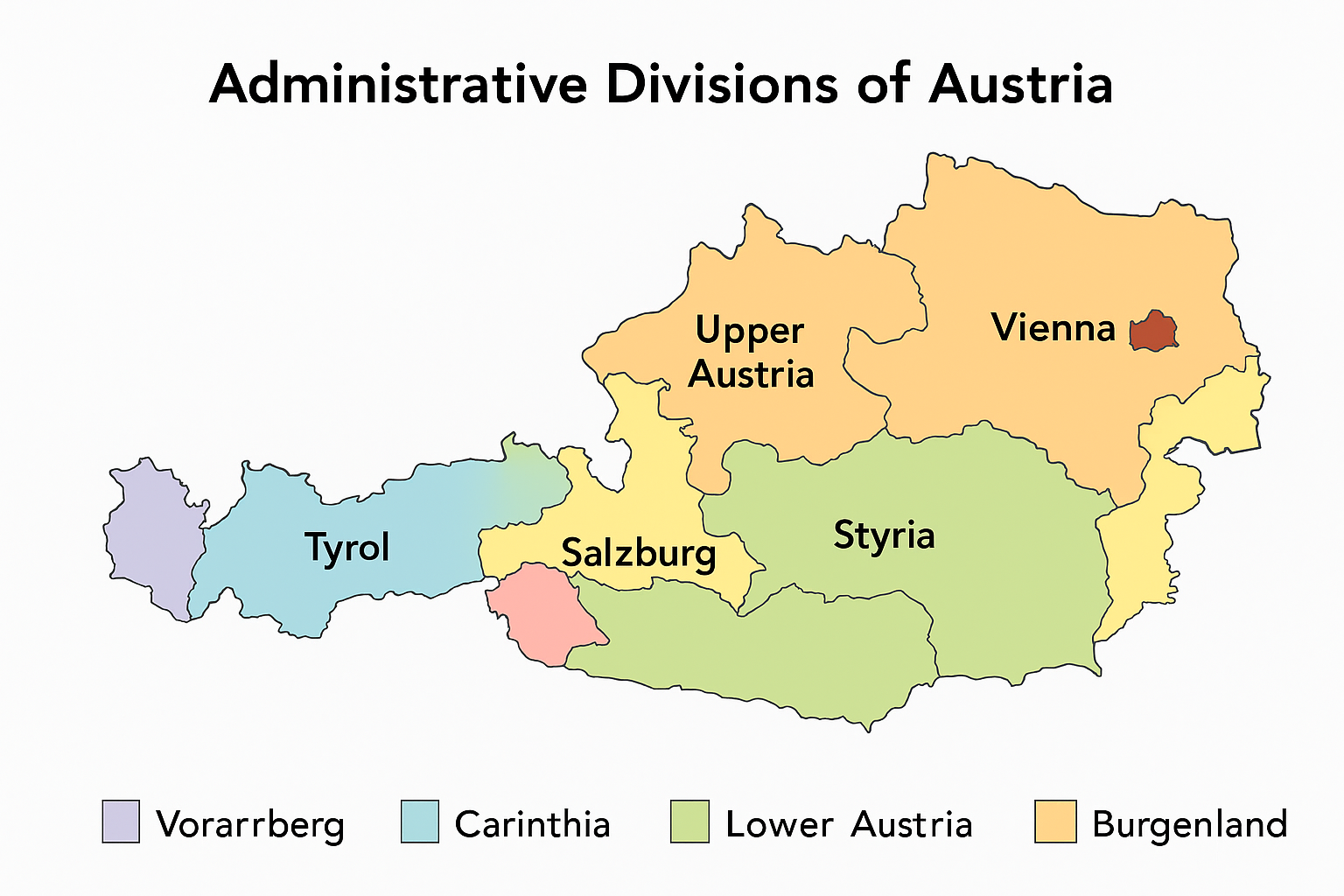
State Profiles
1. Burgenland
ive structure: Part of the nine-Länder system.
Municipalities: Austria in total has about 2,096 municipalities as of recent count. (Exact current count for Burgenland may vary but the principle holds.)
Economy & sector notes: Burgenland is known for agriculture, wine production (especially in the Neusiedl region), and increasingly for renewable energy (wind farms, solar).
Highlights: It is Austria’s easternmost Land, borders Hungary, and has relatively low population density compared to Austria’s more urban states.
Administration: Includes a mix of mountain and valley municipalities, which poses logistical challenges for infrastructure and services.
3. Lower Austria (Niederösterreich)
Capital: Sankt Pölten.
Area: ~19,178 km².
Population: ~1,665,753 (1 Jan 2017).
Economy: A highly diversified economy — agriculture (wine, grain), manufacturing, services; close to Vienna so substantial commuter flows.
Administration: Being the largest Land by area, it has many municipalities, including both small rural ones and larger towns.
4. Salzburg (state)
Capital: Salzburg (city).
Area: ~7,154 km².
Population: ~549,263 (1 Jan 2017).
Key features: Strong tourism sector (heritage city + Alps), music and culture (Mozart), alpine manufacturing and outdoor-industry clusters.
Municipalities & districts: Mix of valley municipalities and mountainous ones — local administration has to deal with tourism management as well as local services.
5. Styria (Steiermark)
Capital: Graz.
Area: ~16,401 km².
Population: ~1,237,298 (1 Jan 2017).
Economy: Known as “the green heart of Austria” — extensive forests, mix of agriculture, strong industrial/trade sectors (especially around Graz), as well as research/university presence.
Administration: A mix of large urban municipalities (Graz) and quite rural, mountainous municipalities in the south and east.
6. Tyrol (Tirol)
Capital: Innsbruck.
Area: ~12,648 km².
Population: ~746,153 (1 Jan 2017).
Key sectors: Alpine tourism (skiing, hiking), winter sports, manufacturing (especially metal and machining industries), high value tourism.
Municipal and district issues: Many municipalities are in mountainous terrain, which impacts delivery of public services, accessibility, transport.
7. Upper Austria (Oberösterreich)
uring, steel, chemical industries, logistics (Danube corridor).
Administration: A significant number of municipalities, including many larger towns in the Danube/Inn corridors as well as rural ones.
8. Vienna (Wien)
t is both a federal state (Land) and a statutory city (Statutarstadt) with district-level competencies.
Area: ~415 km².
Population: ~1,867,582 (1 Jan 2017).
Economy: Capital city functions (government, culture, commerce), very high population density (~4,500 /km²) in the given data.
Administration: Since it is both Land and municipality, governance structures are streamlined relative to multi‐tier states; the municipal government handles many tasks.
9. Vorarlberg
Capital: Bregenz.
Area: ~2,601 km².
Population: ~388,752 (1 Jan 2017).
Economy: Westernmost Austrian state, border to Switzerland and Germany, strong in precision engineering, wood‐industry, alpine tourism; higher GDP per capita noted.
Municipal structure: Smaller geographic size but many municipalities; mountainous terrain means many small local governments.
Map-based Breakdown of Districts and Municipalities
utarstädte).
As of recent counts: Approximately 94 districts (of which 15 are statutory cities) in Austria.
Municipalities (Gemeinden) in Austria: roughly 2,096 as of 2020.
Hence the hierarchy: Land → District (or statutory city) → Municipality.
The maps above visualize how many districts each Land has, how municipalities are distributed especially in rural vs urban zones.
Observations from the map patterns
The eastern states (Lower Austria, Burgenland) have relatively large flat or gently hilly areas with many municipalities, some of which are small.
Alpine states (Tyrol, Salzburg, Vorarlberg) have municipalities more spread vertically (along valleys) and smaller in population, more numerous in number relative to area, due to terrain.
Urbanised states (Vienna, Upper Austria with Linz, Styria with Graz) show clustering of municipalities around metropolitan centres; statutory cities simplify some administrative layers.
Statutory cities: In some states certain large cities function as both municipality and district level — this is visible on maps as distinct units.
Additional Notes & Governance Implications
The number of municipalities is subject to reform: small municipalities are often challenged by declining population, cost of delivering services, and infrastructure maintenance. As such, some Länder encourage municipal mergers or increased cooperation among municipalities.
District level (Bezirk) provides services like local offices, some supervision of municipalities, but in statutory city areas the city administration takes those district tasks directly.
Geographic diversity across the Länder (from Danube plains to high Alps) means municipal and district administration must adapt to terrain, population density, and infrastructure needs (e.g., mountain transport, seasonal tourism).
Fiscal and administrative capacity varies: Urban municipalities tend to have stronger tax bases; very rural municipalities may rely heavily on inter-governmental transfers or cooperative structures.
Nigeria states and capitals, population, land area States of Nigeria; their capitals, population, land and area in Km² StateCapitalPopulationArea (Km²)AbiaUmuahia2,833,9994,857AdamawaYola3,168,10137,957Akwa IbomUyo3,920,2086,788AnambraAwka4,182,0324,761BauchiBauchi4,676,46548,197BayelsaYenagoa1,703,3589,363BenueMakurdi4,219,24430,755BornoMaiduguri4,151,19372,767Cross RiverCalabar2,888,96622,112DeltaAsaba4,098,39117,095EbonyiAbakaliki2,173,5016,342EdoBenin City3,218,33219,584EkitiAdo-Ekiti2,384,2125,797EnuguEnugu3,257,2987,560Federal Capital TerritoryAbuja1,405,2017,569GombeGombe2,353,87917,428ImoOwerri3,934,8995,135JigawaDutse4,348,64923,415KadunaKaduna6,066,56244,217KanoKano9,383,68220,389KatsinaKatsina5,792,57823,822KebbiBirnin Kebbi3,238,62836,320KogiLokoja3,278,48729,063KwaraIlorin2,371,08933,792LagosIkeja9,013,5343,475NasarawaLafia1,863,27526,633NigerMinna3,950,24972,065OgunAbeokuta3,728,09816,850OndoAkure3,441,02415,019OsunOshogbo3,423,5358,585OyoIbadan5,591,58927,036PlateauJos3,178,71226,539RiversPort Harcourt5,185,40010,361SokotoSokoto3,696,99932,146TarabaJalingo2,300,73659,180YobeDamaturu2,321,59144,880ZamfaraGusau3,259,84633,667Total140,003,542911,519…
Ghana districts. Population, size of land area and capitals of districts The districts of Ghana and their population, land area and capitals are as follows: DistrictPopulationArea (km.²)CapitalAbura-Asebu-Kwamankese90,093324Abura-DunkwaAccra1,659,136185AccraAdansi East129,3251,380New EdubiaseAdansi West235,680828ObuasiAfigya Sekyere117,653770AgonaAfram…
Tanzania regions: Population, land area and capitals Regions of Tanzania by population, land area and capitals RegionPopulationArea (Km²)CapitalArusha1,694,31033,809ArushaDar es Salaam4,364,5411,393Dar es SalaamDodoma2,083,58841,311DodomaGeita1,739,530 GeitaIringa941,23856,864IringaKagera2,458,02328,388BukobaKatavi564,604 MpandaKigoma2,127,93037,037KigomaKilimanjaro1,640,08713,309MoshiLindi864,65267,000LindiManyara1,425,13146,359BabatiMara1,743,83019,566MusomaMbeya2,707,41060,350MbeyaMorogoro2,218,49270,799MorogoroMtwara1,270,85416,707MtwaraMwanza2,772,50919,592MwanzaNjombe702,097 NjombePemba North211,732574WetePemba South195,116332Chake ChakePwani1,098,66832,407Dar es SalaamRukwa1,004,53968,635SumbawangaRuvuma1,376,89163,498SongeaShinyanga1,534,80850,781ShinyangaSimiyu1,584,157 BariadiSingida1,370,63749,341SingidaTabora2,291,62376,151TaboraTanga2,045,20526,808TangaZanzibar…
Nigeria’s 36 States and Capitals The 36 States of Nigeria and their capitals are: SNStateCapital1AbiaUmuahia2AdamawaYola3Akwa IbomUyo4AnambraAwka5BauchiBauchi6BayelsaYenagoa7BenueMakurdi8BornoMaiduguri9Cross RiverCalabar10DeltaAsaba11EbonyiAbakaliki12EdoBenin City13EkitiAdo-Ekiti14EnuguEnugu15GombeGombe16ImoOwerri17JigawaDutse18KadunaKaduna19KanoKano20KatsinaKatsina21KebbiBirnin Kebbi22KogiLokoja23KwaraIlorin24LagosIkeja25NasarawaLafia26NigerMinna27OgunAbeokuta28OndoAkure29OsunOshogbo30OyoIbadan31PlateauJos32RiversPort Harcourt33SokotoSokoto34TarabaJalingo35YobeDamaturu36ZamfaraGusau List of Nigeria’s 36 states…
List of Nigeria states and capitals The states and capitals of the Federal Republic of Nigeria are: SNStateCapital1AbiaUmuahia2AdamawaYola3Akwa IbomUyo4AnambraAwka5BauchiBauchi6BayelsaYenagoa7BenueMakurdi8BornoMaiduguri9Cross RiverCalabar10DeltaAsaba11EbonyiAbakaliki12EdoBenin City13EkitiAdo-Ekiti14EnuguEnugu15GombeGombe16ImoOwerri17JigawaDutse18KadunaKaduna19KanoKano20KatsinaKatsina21KebbiBirnin Kebbi22KogiLokoja23KwaraIlorin24LagosIkeja25NasarawaLafia26NigerMinna27OgunAbeokuta28OndoAkure29OsunOshogbo30OyoIbadan31PlateauJos32RiversPort Harcourt33SokotoSokoto34TarabaJalingo35YobeDamaturu36ZamfaraGusau Federal territory (similar…
Gurk Cathedral: A Romanesque Jewel of Austria Nestled in the serene Gurktal Valley of Carinthia, Austria, Gurk Cathedral (Dom zu Gurk, officially Pfarr- und ehemalige Domkirche Mariae Himmelfahrt) stands as…
World Heritage Sites in Austria UNESCO World Heritage Sites in Austria are: Historic Centre of the City of Salzburg Palace and Gardens of Schönbrunn Hallstatt-Dachstein…
, State Capitals, Land Area, Population, GDP, Subdivisions (Districts, Cities and Municipalities)")


