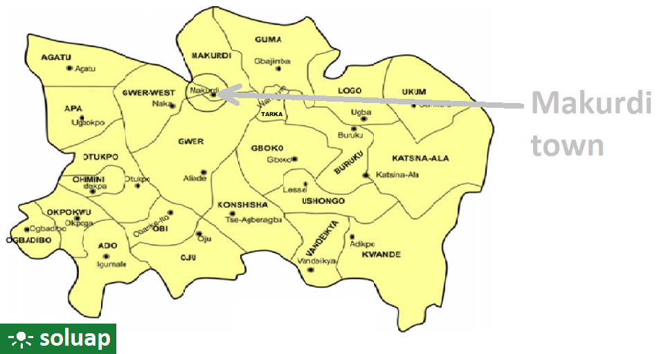
Major cities: Makurdi, Gboko Otukpo, Katsina-Ala, Zaki-Biam, Ukum and Adikpo.
Local Government Areas (LGAs): Ado, Agatu, Apa, Buruku, Gboko, Guma, Gwer East, Gwer West, Katsina-Ala,Konshisha, Kwande, Logo,Makurdi, Obi, Ogbadibo, Ohimini, Oju, Okpokwu, Otukpo, Tarka, Ukum, Ushongo, Vandeikya
Ethnic Profile: Tiv, Idoma, Igede, Etulo, Abakpa, Jukun, Hausa, Akweya and Nyifon. The Tiv are the dominant ethnic group, occupying fourteen (14) local government areas, while the Idoma and Igede occupy the remaining nine local government areas.
Economic Profile: Its major agricultural produce include yam, rice, beans, cassava, potatoes, maize, soya beans, sorghum, millet and cocoyam. The state also accounts for over 70% of Nigeria’s soya beans production.
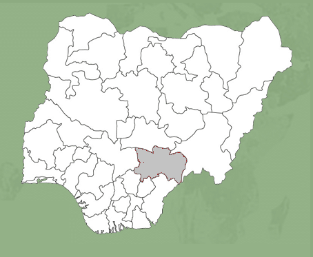
Geographic Location: Its geographic coordinates are longitude 7° 47’ and 10° 0’ East. Latitude 6° 25’ and 8° 8’ north; and shares boundaries with five other states namely: Nasarawa to the north, Taraba to the east, Cross-River to the south, Enugu to the south-west and Kogi to the west. The State also shares a common boundary with the Republic of Cameroun on the south-east.
Benue State, Nigeria Benue state was created on February 3, 1976. It was one of the seven new states created by the military…
Places, with Latitude and Longitude, in Guma LGA, Benue State, Nigeria PLACELATITUDELONGITUDEAbinsi7.7502308.250732Achie I/Mbalisa8.0598408.672870Achie II8.1160208.702750Adagu7.9554808.860830Adasho8.1014708.401490Adawagi II8.0500208.363290Adoyem(Wombu)8.0361208.512300Agar7.8356508.734960Agasha7.7094008.865400Agben8.1476808.455910Agber8.0607608.675590Ahsuku Island7.8115408.926040Ajimnee (Mbayer II)8.1654138.624380Akulayem7.9321408.544250Akumba7.7337708.769990Ambutor8.0706508.681260Anbar8.4214308.421430Andyar-Mbachikiv7.7464409.040510Angbaaye7.7367108.704440Anuha Island I7.8058108.890700Anuha Island II7.8187508.868000Aondokume7.9272808.834330Awange8.0899008.502903Ayeri8.0661808.426110Ayia-Mbalortyon8.0497788.510610Ayokpe-Ujam7.9107908.711510Azom Utange7.7247008.813350Azyoko7.7529608.742690Beetse8.1165308.381950Benco Settlement7.7529208.736700Ber-Anyabe8.0610208.862890Buaka Aha Mbagbaav7.6785009.063690Cam Garba7.8717808.588240Chemberger-Ukum8.0627908.781700Chiaka I7.8723808.631320Chiaka II8.0997908.004740Dankye-Mbabun7.7468508.895480Daudu7.9058908.566790Gbabua8.0630208.990840Gbajimba7.8215808.854500Gbeleke Mbabun7.7597108.899300Gbenyam-Ngbianjor8.0042608.762970Ginde7.6783509.082060Guma/Mbatako II7.9920708.719760Hirnyam7.9830108.563580Hirw…
Map of Guma local government area, Benue State, Nigeria Guma Council wardsGuma local government area is made up of ten (10) council wards namelyKaambeAbinsiUvirSaghevNzorovNyievMbabaiMbayer or YandevMbawa, andMbadwen Major placesGbajimba,…
Makurdi Airport, Benue State, Nigeria Makurdi Airport is located along Makurdi – Gboko road in Makurdi town, the capital of Benue State. The airport belongs…
Idoma People of Benue State, Nigeria The Idoma people are the second-largest ethnic group in Benue State, Nigeria. They primarily inhabit seven local government areas in…
Benue State Judiciary Judges, courts, departments, management team, faith JudgesThe Benue State Judiciary began with touring sessions which were held by Judges of…


")


