Ecuador’s 24 Provinces and the Seven Regions That Bind Them
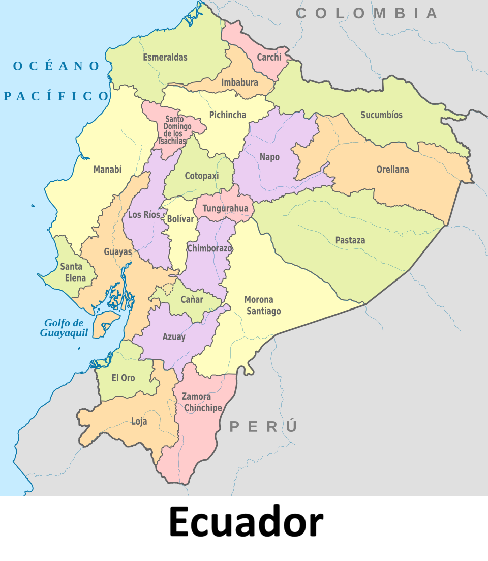
Ecuador is a small country with a complex internal map. It is divided into 24 provinces (provincias), each with its own administrative capital. Above the provincial level sits another layer: a system of regions, or zones, designed to spread administrative power beyond the capital, Quito.
What regionalization means
Regionalization, or zoning, joins two or more neighboring provinces into a single region. The aim is to decentralize the administrative functions of Quito so that planning and services are coordinated closer to the communities they serve. Ecuador has seven such regions, each made up of a group of provinces and each with its own administrative city.
The seven regions
Region 1 (42,126 km² / 16,265 sq mi) covers the northern part of the country: Esmeraldas, Carchi, Imbabura, and Sucumbíos. Its administrative city is Ibarra.
Region 2 (43,498 km² / 16,795 sq mi) combines Pichincha, Napo, and Orellana. Its administrative city is Tena.
Region 3 (44,710 km² / 17,263 sq mi), the largest by area, groups Chimborazo, Tungurahua, Pastaza, and Cotopaxi. Its administrative city is Riobamba. Tungurahua is home to the Cabellera de la Virgen waterfall in Baños de Agua Santa, one of the country’s best-known natural sights.
Region 4 (22,257 km² / 8,594 sq mi), the smallest, includes only two provinces: Manabí and Santo Domingo de los Tsáchilas. Its administrative city is Ciudad Alfaro.
Region 5 (38,420 km² / 14,834 sq mi) is the most provincially diverse, with five members: Santa Elena, Guayas, Los Ríos, Galápagos, and Bolívar. Its administrative city is Milagro.
Region 6 (38,237 km² / 14,763 sq mi) brings together Cañar, Azuay, and Morona Santiago. Its administrative city is Cuenca.
Region 7 (27,571 km² / 10,645 sq mi) in the south joins El Oro, Loja, and Zamora Chinchipe. Its administrative city is Loja.
Two metropolitan exceptions
Not every part of the map fits neatly into this scheme. Quito and Guayaquil, the country’s two largest cities, are designated Metropolitan Districts, a status that sets them apart in administrative terms.
The Galápagos exception
The Galápagos Islands are the most unusual case. They are formally included in Region 5, yet they also fall under a special administrative unit of their own. The arrangement reflects the islands’ distinct character: they are geographically far from the mainland and require governance tailored to their circumstances.
A map built for balance
Taken together, the seven regions show how Ecuador has tried to balance a centralized capital with a country of very different landscapes, from coastal lowlands to Andean highlands to Amazonian provinces. The system is not uniform. Regions vary widely in size and in the number of provinces they contain, and special statuses like those of Quito, Guayaquil, and the Galápagos add further nuance.
World Heritage Sites in Ecuador UNESCO World Heritage Sites in Ecuador are: City of Quito Galápagos Islands Sangay National Park Historic Centre of Santa Ana…
Belgium Communities, Regions, and Language Areas Belgium’s institutional structure is one of the most sophisticated in Europe. Shaped by linguistic diversity, historical compromise, and successive waves…
List of Belarus Districts and Regions Belarus is divided into six regions (voblasts), each comprising numerous districts that serve as the fundamental administrative units of local…
List of Azerbaijan Regions, Rayons and Cities Azerbaijan, a country strategically located at the crossroads of Eastern Europe and Western Asia, has a well-structured system of governance…
Uganda Districts and Regions Uganda districts and regions. Learn their population, geographic divisions, history, and governance structure in this detailed guide. Uganda, often called…
List of Namibia Regions and Constituencies Namibia is a unitary state divided into 14 administrative regions, each with its own regional council. These regions are further…
List of Uganda Districts, Regions and Subregions Uganda’s administrative classification into regions, sub-regions, and districts reflects the country’s diversity: administratively, culturally and geographically. Classification of Uganda into…
Chad regions and departments The Republic of Chad has regions which are further divided into departments. The regions and their departments are: RegionDepartmentsBathaBatha Est, Batha…