Guma is a local government area in Benue State, Nigeria.
Founded Guma local government area was created in 1987 out of Makurdi local government area
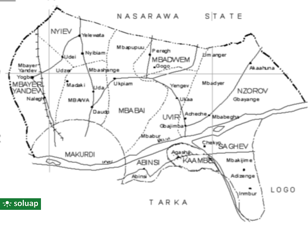
Headquarter Guma local government area’s headquarter is in Gbajimba.
Land area Guma has a land area of 2,882 km2 making it the largest local government area in Benue State
Location Its location is on latitude (06° 33′ and 07° 03′) North and also longitude (07°60′ and 08° 12′) East.
Boundaries Guma shares boundaries with Tarka and Logo local government areas in the east, Makurdi local government in the South, Doma local government area of Nassarawa in the North.
Council wards Guma local government area is made up of ten (10) council wards namely Kaambe Abinsi Uvir Saghev Nzorov Nyiev Mbabai Mbayer or Yandev Mbawa, and Mbadwen
People The people of Guma are predominately Tiv clans of Ihyarev and Nongov.
Prominent persons include Samuel Ortom (Benue state governor, 2015 – 2023), Dickson Tarkighir, a former House of Reps member among others.
Places Major urban places include Gbajimba, Agasha,, Daudu,Torkula, Kase-yough, Abinsi and several towns along Makurdi to Nasarawa road
Areas in Guma
Mbaawa Atawa Gyushage Jugudu
Mbabai Ikoanenge Ortserga Tse-Tule Uikpam
Mbagwen Nalegh Talvough Yogbo
Mbasaan Antso Cheakiyne Gogo Ichergbe Ijoh Iye Kaseyo Peregh Torkula Toura Tse-Akenyi Ubo Ukaa Umenger Yeshewe
Guma. Map of Benue state showing Guma local government area Benue State’s 23 local government areas:AdoAgatuApaBurukuGbokoGumaGwer EastGwer WestKatsina-AlaKonshishaKwandeLogoMakurdiObiOgbadiboOhiminiOkpokwuOjuOtukpoTarkaUkumUshongoVandeikya
Places, with Latitude and Longitude, in Guma LGA, Benue State, Nigeria PLACELATITUDELONGITUDEAbinsi7.7502308.250732Achie I/Mbalisa8.0598408.672870Achie II8.1160208.702750Adagu7.9554808.860830Adasho8.1014708.401490Adawagi II8.0500208.363290Adoyem(Wombu)8.0361208.512300Agar7.8356508.734960Agasha7.7094008.865400Agben8.1476808.455910Agber8.0607608.675590Ahsuku Island7.8115408.926040Ajimnee (Mbayer II)8.1654138.624380Akulayem7.9321408.544250Akumba7.7337708.769990Ambutor8.0706508.681260Anbar8.4214308.421430Andyar-Mbachikiv7.7464409.040510Angbaaye7.7367108.704440Anuha Island I7.8058108.890700Anuha Island II7.8187508.868000Aondokume7.9272808.834330Awange8.0899008.502903Ayeri8.0661808.426110Ayia-Mbalortyon8.0497788.510610Ayokpe-Ujam7.9107908.711510Azom Utange7.7247008.813350Azyoko7.7529608.742690Beetse8.1165308.381950Benco Settlement7.7529208.736700Ber-Anyabe8.0610208.862890Buaka Aha Mbagbaav7.6785009.063690Cam Garba7.8717808.588240Chemberger-Ukum8.0627908.781700Chiaka I7.8723808.631320Chiaka II8.0997908.004740Dankye-Mbabun7.7468508.895480Daudu7.9058908.566790Gbabua8.0630208.990840Gbajimba7.8215808.854500Gbeleke Mbabun7.7597108.899300Gbenyam-Ngbianjor8.0042608.762970Ginde7.6783509.082060Guma/Mbatako II7.9920708.719760Hirnyam7.9830108.563580Hirw…
Map of Guma local government area, Benue State, Nigeria Guma Council wardsGuma local government area is made up of ten (10) council wards namelyKaambeAbinsiUvirSaghevNzorovNyievMbabaiMbayer or YandevMbawa, andMbadwen Major placesGbajimba,…