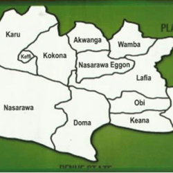
Nasarawa State is centrally located in the Middle Belt region of Nigeria.
It shares boundary with Kaduna state in the North, Plateau State in the East, Taraba and Benue states in the south while Kogi and the Federal Capital Territory flanks it in the West.
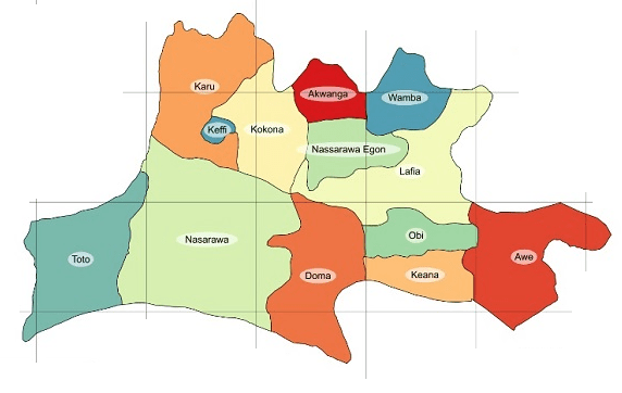

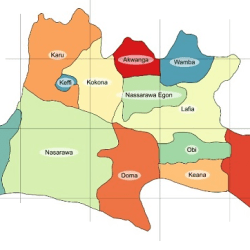
Nasarawa State is made up of thirteen Local Government Areas, namely, Akwanga, Awe, Doma, Karu, Keana, Kokona, Lafia, Nasarawa, Nasarawa Eggon, Obi, Toto, Wamba and Keffi. The people of Nasarawa state includes among others; the Gwandara, Alago, Eggon, Gbagi, Egbira, Migili, Kantana, Fulani, Hausa, Kanuri, Tiv, Afo, Gade, Nyankpa, Koro, Jukun, Mada, Ninzam, Buh, Basa, Agatu, Arum, Kulere, and also settler groups like the Igbo, Yoruba and Hausa.

The state has a total land area of 26,875.59 square kilometers and a population of about 1,826,883, according to the 2006 population Census estimate with a density of about 67 persons per square kilometer. The state lies between latitude 7° 45′ and 9° 25’ N of the equator and between longitude 7° and 9° 37′ E of the Greenwich meridian.

The creation of present-day Nasarawa State owes its origin to the British creation of Nasarawa Province in 1902. Nasarawa was at first called the Lower Benue Province in 1900, but after the formal submission of the Emir of Nasarawa in 1902, the name of the Province was changed to Nasarawa and the capital was moved from Akpanaja to Nasarawa town.
Following the reorganisation of the Northern Provinces in 1926, Plateau Province was created out of the Provinces of Muri, Nasarawa and Bauchi.
Some of the groups that were formally under Nasarawa Province were transferred to Plateau while others were incorporated into Benue Province. In May 1967, Benue and Plateau Provinces were merged to form Benue-Plateau State, one of the twelve states that the Military Administration of General Yakubu Gowon divided Nigeria in place of the four previously existing regions. When the country was further divided into nineteen states in 1976, Benue-Plateau State was split into Plateau and Benue States. In October 1996, Nasarawa state was created out of the western half of Plateau State with its capital in Lafia.
The general topography of Nasarawa State is that of hills/ dissected terrain, undulating plains and lowlands. A look at the state from the south to the north shows that the southern local government areas of Awe, Doma, Nasarawa and Toto are bounded by the river Benue in the south. Its valley and troughs extend inland for some 30 kilometers and it is made up of flood plains lying generally below 250 metres. The flood plains further protrude inland along the coast of rivers Dep, Mada, Guma, Ayini and Farin Ruwa which are the major rivers draining into the river Benue. The area consists of very fertile alluvial soil deposited by the seasonal flood of river Benue.
The hydromorphic soil provides a generally level plain, except where it is broken by the folded features of Awe to the south east and those of Toto to the south west. The flood plains cover some 25 per cent of the state landmass. The flood plains give way to a rolling topography which is quite extensive and it covers about 52 per cent of Nasarawa State. The undulating plain has a general altitude of about 400 meters above sea level with notable inselberg occurrences. The soils in this region are those of sandstones derived from old sedimentary rocks with extensive occurrences of lateritic crust. Hills and dissected terrains occupy a sizeable portion of Nasarawa state and are scattered all over the land mass with height range of between 600 – 1200 meters. The northern part of the state has a greater concentration with the Monkwa hills in the northeast and the Mada rolling hills stretching from Wamba through Akwanga down to Nasarawa Eggon local government areas. The Rafin gabas hills are a prominent feature in Kokona L.G.A., while the north western borders of the state are flanked by hill ranges. In the southern part of the state, high relief features also occurs in Toto and Awe local government areas. Soils at the foot of these hills are mostly volcanic in nature and therefore loamy and rich, while the higher grounds are characterised by thin soil.
The physical features of the State are partly mountainous, some of which are rocky and of undulating highlands to average height of about 1,400m above sea level.
Areas such as Nasarawa, Nassarawa Eggon, Wamba, Keffi and Akwanga are generally hilly and rocky, while areas such as Lafia, Doma, Awe and Keana are fairly of plain terrains. The river Benue has its tributaries covering other parts of the State.
The State has a climate typical of the tropical zone because of its location and is quite pleasant. It has a maximum and minimum temperature of 81.7ᵒ F and 16.7ᵒ F respectively. Rainfall varies from 131.73cm in some places to 145cm in others. The months of December, January and February are cold due to harmattan wind blowing across the State from the North-East. It is characterized by two distinct season: dry and rainy. The dry season spans from November to February, while the rainy season is from March to October.
Nasarawa state is richly endowed with a variety of solid minerals of various categories ranging from precious metals to various gemstones and also industrial minerals such as barites, gypsum, kaolin and marble. Much of these are yet to be exploited. Statistically, the level of exploitation of these minerals is very low in relation to the extent of deposits found in the state. One of the objectives of this administration is to ensure the orderly exploration and exploitation of the mineral resources of the state.
There are tremendous opportunities for investments in the solid mineral sector and some of the mineral resources that are found in Nasarawa state are yet to be fully exploited. These minerals include among others, coal and tin, iron ore, limestone, niobium, lead and zinc.
COAL
High-medium volatile bituminous coals with vitrinite reflectivity in the range of 0.70 to 1.20 per cent occur within the Awgu Formation and widely exposed in outcrops along the bank of River Dep at Shankodi near Jangwa and in the Obi-Agwatashi-Jangerigeri areas. These coal deposits are of the best quality in Nigerian and have been assessed to be suitable for coke making in steel manufacture. The vitrinite reflectance values of the coals (0.70 to 1.20 per cent) also fall within the “oil generation window.” Coal beds are now widely known to be a major source of oil and gas and are becoming increasingly exploration targets for hydrocarbon accumulations in many parts of the world.
BARYTES
Barytes is the chief constituent of lithopone paint and it is also extensively used as an inert volume and weight filler in drilling mud, rubber, glass, paper and in the chemical industry. Veins of barytes up to 1.8m wide and more than a kilometer long are associated with lead-zinc lodes in many parts of Nasarawa State. The principal known occurrences are at Azara, Aloshi, Akiri, Wuse and Keana. Reserves of about 100,000 tonnes of good quality barytes have been discovered in Azara by the Nigerian Mining Corporation.
LEAD AND ZINC
Lead is used in the manufacture of cable coverings, pigments and storage batteries. Other uses of zinc include galvanizing steel plate, the manufacture of brass and other alloys, rubber vulcanizing, and the production of pigments and certain medicines and chemicals. Lead and zinc deposits occur within the sedimentary successions at Arufu, Akwana, Azara, Keana and Awe.
PRECIOUS METALS
Precious metals are a valuable source of foreign exchange and their exploitation in a large scale can also promote the establishment of other ancillary industries in Nasarawa state. In Nasarawa State, some quantities of gold deposits occur in pegmatite-quartz veins within Precambrian basement rocks in Wamba. The Metasedimentary rocks in Toto, Udegbe, Gadabuke, Laminga and Nasarawa are also contains some gold deposits with mode of occurrence similar to those in Schist Belts.
GEMSTONES
Like the precious metals, gemstones can be an important source of income for Nasarawa state. There are varieties of gemstones and the important ones in terms of quantity are aquamarine, emeralds, sapphire, ruby, topaz, tourmaline, zircon and almandine. Most of the gemstones occur in pegmatites and quartz veins in rocks of the Basement Complex and Younger Granites in Nasarawa State.
SOIL
The sediments generally comprise of sandstones, siltstones and subordinates inter-bedded clays all of cretaceous age. Alluvial soils are found along the flood plains which are always swampy in nature due to availability of water all the year round. The forest soils are rich in humus and laterite soils. They are found in most parts of the State and very good for crop production.
