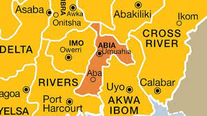
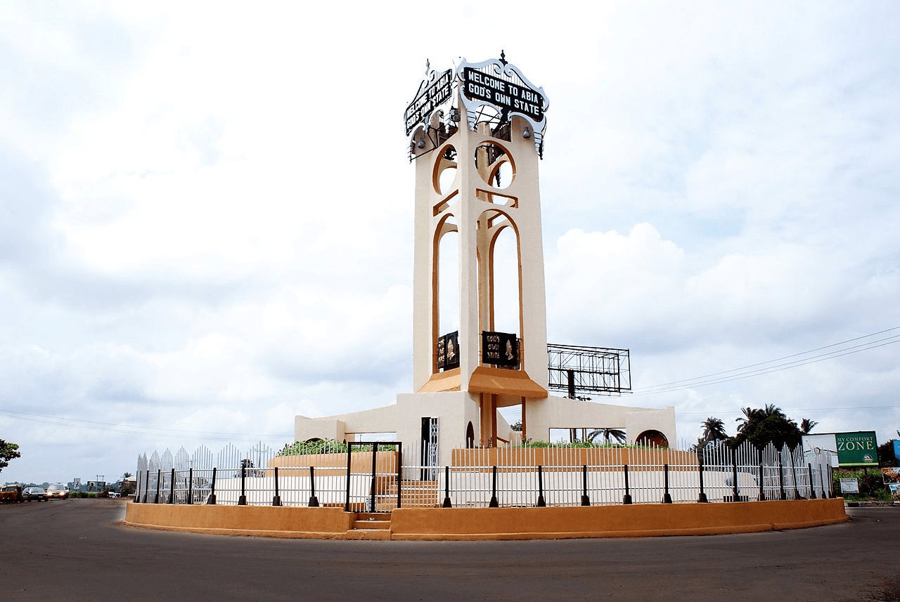
Abia State is a state in south-eastern Nigeria. Umuahia is the capital and Aba is largest city and commercial centre.
Abia was created on 27 August 1991 from the eastern part of Imo state, and it takes its name from the acronym of four of its most populated regions: Aba, Bende, Isuikwuato, and Afikpo.
The state is bordered by Anambra, Enugu, Ebonyi, Imo, Cross River, Akwa Ibom, and Rivers states, and it is the only Southeastern state that has boundary with all the other four Southeastern states in Nigeria.
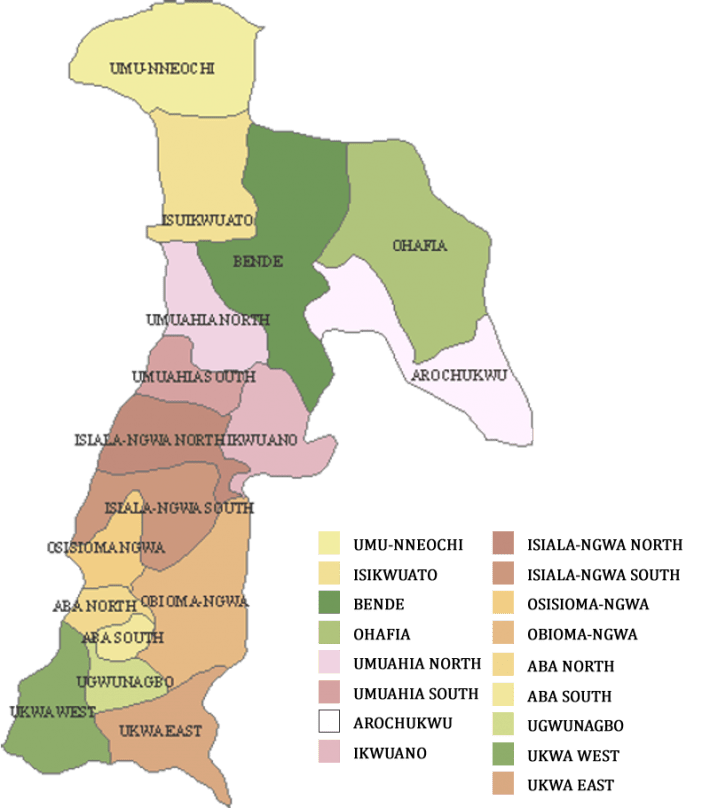
Abia has 17 Local Government Areas (LGAs), namely:
Aba North
Aba South
Arochukwu
Bende
Ikwuano
Isiala-Ngwa North
Isiala-Ngwa South
Isuikwuato
Obi Ngwa
Ohafia
Osisioma Ngwa
Ugwunagbo
Ukwa East
Ukwa West
Umuahia North
Umuahia South
Umu-Nneochi
The Local Government Areas and their capitals are:
Aba North Headquarters: Eziama Uratta
Aba South Aba
Arochukwu Arochukwu
Bende Bende Town
Ikwuano Isiala Oboro
Isiala-Ngwa North Okpuala-Ngwa
Isiala-Ngwa South Omoba
Isuikwuato Nbalano
Obi Ngwa Mgboko
Ohafia Eben Ohafia
Osisioma Ngwa Osisioma
Ugwunagbo Ugwunagbo
Ukwa East Akwete
Ukwa West Oke-Ikpe
Umuahia North Umuahia City
Umuahia South Apumiri Ubalaka
Umu Nneochi Amuda Nkwoagu
The state is rich in natural resources such as crude oil, natural gas, limestone, clay, salt, coal, palm oil, cassava, yam, plantain, banana, maize, rice, and cocoa.
It is also known for its industrial and commercial activities, especially in Aba, which is famous for its leather works, textiles, cosmetics, plastics, pharmaceuticals, soap, and footwear industries.
Abia has a vibrant culture and tourism sector, with attractions such as the National War Museum in Umuahia, the Azumini Blue River in Ukwa East LGA, the Arochukwu Long Juju Slave Route in Arochukwu LGA, the Ngodo Cave in Isuikwuato LGA, and the Abia Tower in Umuahia.
People
The people of Abia are mainly of the Igbo ethnic group. English is widely spoken and serves as the official language in governance and business while the Igbo language serves as a native tongue. Globally, the Igbo’s are well travelled. They are known to be tolerant, ultra-democratic and reputed to be industrious, highly market oriented, very hospitable and accommodating, probably due to their migratory nature. About 2.4million Abia people are very entrepreneurial in nature.
Religion The people of Abia State are predominantly Christians of different denominations. There are also a number of Muslims, with adherents. Some people in the state are animists, who believe in a Being called “Chukwu”. The traditional worshippers believe in the ability of deities to exercise strong influence on the destiny of man.
Location
Located in the southeastern region of Nigeria, Abia State lies within approximately latitudes 4° 40′ and 6° 14′ north, and longitudes 7° 10′ and 8° east. The state shares common boundaries to the north with Ebonyi State; to the south and southwest with Rivers State; and to the east and southeast with Cross River and Akwa lbom States respectively. To the west is Imo State, and to the northwest is Anambra State.
The state covers an area of about 5,243.7 sq. km which is approximately 5.8 per cent of the total land area of Nigeria. With its capital at Umuahia, it has seventeen LGAs, namely: Aba North, Aba South, Isiala Ngwa North, Isiala Ngwa South, Ukwa West, Ukwa East, Obingwa, lkwuano, Bende, Arochukwu, Ohafia, lsuikwuato, Umuahia North, Umuahia South, Ugwunagbo, Osisioma and Nnochi.
Settlement pattern
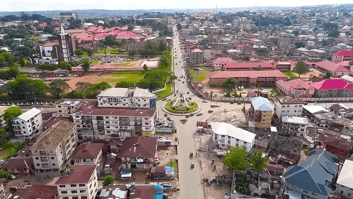
Abia State has two main urban centres, namely: Umuahia and Aba. Umuahia, the state capital, has become the administrative, educational and cultural centre of the It state. In addition, the city is located at the centre of an extensive agricultural region, which covers most of the central part of Abia State. It is also strategically located along a well-established north-south trading and transportation route.
The village is the traditional unit of settlement in Abia State like any other lgbo speaking community. The people are good farmers and keen businessmen. The dispersed type of village settlement is traditional among the lgbos. Each homestead is made up of houses arranged in an oblong form o around a compound.
At the gate or in the middle of the compound is a shrine for the gods. The hut of the head of the household is separated from those of his wives and other adult members of the household. Compounds in lgbo communities are walled, thus separating one compound from the other. Traditional houses are built of local materials such as clay for the walls and roofed with mat or thatch or, in more recent times, with corrugated aluminum sheets as a demonstration of increasing prosperity.
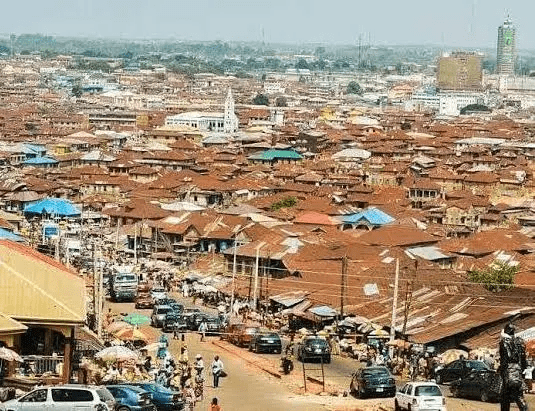
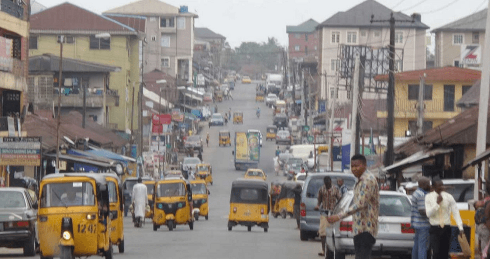
The Problem of Urban Primacy: Of the two major towns in Abia State (Aba and Umuahia), Aba is the largest. The town is situated on a plain with Aba River Valley on its eastern side as the only prominent physical feature. It is about 60 km south of Umuahia, the state capital. According to the 1991 provisional census, the population of the area, now split into two LGAs (Aba North and Aba South), was 494,152 people.
The town is accessible by road from all parts of the eastern states (Imo, Ebonyi, Cross River, Rivers, Akwa loom, Anambra and Enugu States). Aba is one of the railway stations on the eastern railway. It has the largest concentration of people in the state. It is the largest commercial centre in the state with the famous Ariaria Market sited west of the town, close to the Port-Harcourt-Enugu Expressway.
Besides, there is the Ngwa Market, the Cemetery Market and virtually every street in Aba has its share of the business activities for which the town is known. There are a good number of both public and private industrial establishments as well as financial institutions
As a result of the primate role enjoyed by Aba in the hierarchy of settlements in the state, enormous environmental problems have become manifest. These include refuse heaps, traffic congestion, overcrowding of residential areas, and the pollution of water bodies.
Historical development
“Abia” is an acronym formed from the initial letters of four groups of people, namely: Aba, Bende, lsuikwuato and Afikpo. These constituted the major groups in the state at its creation.
At the country’s independence in 1960, Abia was part of the then Eastern Region. From 27th May, 1967, it became a part of the East Central State, created by the then Head of the Federal Military Government, General Yakubu Gowon. On 3rd February, 1976, East Central State was split into two states(Anambra and Imo) by the Federal Military Government headed by General Murtala Mohammed.
On 27th August, 1991, the Federal Military Government under General lbrahimBabangida carved out Abia State from Imo State, bringing to thirty the number of states in Nigeria. Furthermore, in October, 1996, the Federal Military Government under General SaniAbacha created six more states bringing to thirty-six the number of states in the federation.
During this exercise, four local government areas (LGAs) namely, Onicha, Ohaozara, Afikpo North and Afikpo South, which occupy the northeastern corner of the state, were transferred to the (newly created) Ebonyi State.
Travel
The nearest airport to Abia state is Sam Mbakwe Cargo Airport (Owerri Airport), an hour’s drive to Aba; and Port Harcourt International Airport (airport code: PHC), 2 hours to Aba and about three hours to Umuahia. The Distance between Uyo (Akwa Ibom) and Umuahia (Abia) is: 73.28 kilometers (km). The approximately estimated travel/road distance can be around 84.27 km to 91.6 km In Other Unit: 45.54 miles. The approximately estimated travel/road distance can be around 52.37 miles to 56.92 miles 39.54 nautical miles. The approximately estimated travel/road distance can be around 45.47 nautical miles to 49.42 nautical miles.
The rail transport is also another means of travel, very effective but currently on revitalization. The Coastal parts of the State are equally
Festivals, arts and crafts
Each community in Abia State has different festivals celebrated in honour of its gods and goddesses, or to mark important events. The beginning of the planting season as well as the harvest season are celebrated annually. The New Yam festival, celebrated as thanksgiving to God (Chukwu) by everyone, is pervasive in lgbo land.
Works of art produced in the state include carved doors, stools, walking sticks, traditional flutes, mortars, gongs and pestles. One work of art particularly worthy of note is the traditional “Akwete’ cloth of Ukwa East.
An outline of the lgbo cultural heritage will be incomplete without a word or two of the lgbo tradi- tional hospitality to visitors. This is reflected in the presentation of kolanuts to visitors. The kolanut signifies that the visitors are heartily welcome. The rituals of the presentation of the kolanut are con- summated with the offering of prayers and thanks- giving or request to the supreme God and othei deities for the protection of the visitor and the host.
Infrastructure & economy
Crude oil and gas production is a prominent activity, as it contributes to 39% of the GDP. Representing 27% of the GDP, agriculture, which employs 70% of the state workforce, is the second economic sector of Abia. With its adequate seasonal rainfall, Abia has much arable land that produces yams, maize, potatoes, rice, cashews, plantains, and cassava. Abia also has large crude oil deposits. The manufacturing sector only accounts for 2% of the GDP
Relief and drainage
Abia State has a variety of land forms, despite the fact that it is dominated by flat and low-lying land, generally less than 120m above sea-level. The low-lying plain is the inland extension of the coastal plain from the Bight of Benin. The central part of the state is characterized by undulating land with many hills. The highland areas are part of the Enugu – Nsukka – Okigwe cuesta.
This area has an average height of between 120m and 180m above sea-level. From Okigwe (Imo State), this escarpment extends in a west-east direction and, on getting to Afikpo (Ebonyi State), veers south-eastwards to Arochukwu where it terminates.
There are nine main geological formations from south to north. These include: The Benin formation (or Coastal Plain Sand), the Bende-Ameki Group, the Nkporo Shale Group, the Nsukka formation (Upper Coal Measures), the Igali sandstone (False- bedded Sandstone), the Eze-Azu Shale Group and the Asu River Group. The principal rivers in Abia State are the Imo River and its tributary, the Aba River.
Imo River originates from the northwestern part of the state and flows southwest through Abia and Imo state territories towards the Atlantic Ocean, passing through the southern parts of Ukwa-West and Ukwa-East local government areas. Other important rivers include lgwu, Azurnini Blue River and Kwalbo River.
Climate There are two seasons in the year, namely: the rainy season and the dry season. The rainy season begins in March and ends in October with a break in August usually referred to as the “lit- tle dry season.” The dry season which lasts for four months begins in November. Heavy thunderstorm are characteristic of the onset of the rainy season. The total rainfall decreases from 2200mm in the ie south to 1900mm in the north.
The hottest months as are January to March when the mean temperature ts is above 27°C. The relative humidity is usually high throughout the year, reaching a maximum during the rainy season when values above ninety per cent are recorded.
Soils And Vegetation: The soils of Abia State fall within the broad group of ferrallitic soils of the coastal plain sand and escarpment.Other soil types include alluvial soils found along the low ter- race of the Cross River and other rivers. The soils are not particularly fertile and are prone to much “., leaching because of heavy rainfall. The main eco- logical problems in the state are sheet and gully erosion.
The vegetation in Abia State is ordinarily considered part of tropical rain forest which is the dominant natural vegetation in most parts of southern Nigeria.
The northern part of the State has rich Savannah vegetation of which the bamboo (Dendrocalamusstrictus) is a typical grass species. The economic trees of the rainforest community are extremely numerous in species and varied in sizes, but the oil palm appears to be the most important.
Ethnic composition, language and culture:
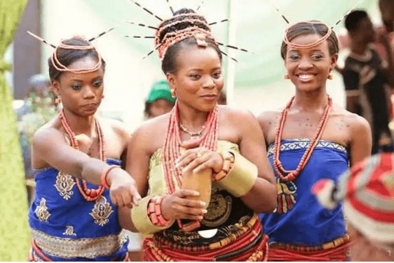
Abia State is inhabited by the lgbo. The lgbo language is spoken throughout the State with no restriction to other languages. Abia State is richly endowed culturally. This is evident in the people’s mode of dressing, dancing, arts and crafts, as well as festivals and the widely known lgbo traditional hospitality.
The traditional apparel for the men is an over-flowing jumper or long-sleeve shirt worn over a “George” wrapper tied around the waist and flowing down to the ankles. This dress is complemented with a cap and a walking stick for support and defence. For the women, the traditional wear is a blouse over an “Abada” or “George”, around the waist. This outfit goes with a headgear, ba earrings and necklace.
Music and dance In Abia State, different types of music abound to suit various occasions. There is music for work, leisure, childbirth, funeral, and for different festivals. Much of the traditional music is a combination of the vocal and instrumental artistry which produces a tuneful melody.
Musical instruments such as the gong, iar, leather drums, wooden drums, traditional flute the (Oja), earthen-pot drums and a host of percussion instruments abound. Some famous traditional lit- music and dances are the Ekpe dance in Arochukwu; the Bende and Ohafia war dance; and the EgwuUkwu (waist dance) of Isiala Ngwa.
More
Nigeria postal codes Postal codes of Nigeria States StatePostal codeAbia 440001Adamawa 640001Akwa Ibom 520001Anambra 420001Bauchi 740001Bayelsa 561001Benue970001Borno600001Cross River540001Delta320001Ebonyi840001Edo300001Ekiti360001Enugu400001Gombe760001Imo460001Jigawa720001Kaduna700001Kano800001Katsina820001Kebbi860001Kogi260001Kwara240001Lagos100001Nasarawa962001Niger920001Ogun110001Ondo340001Osun230001Oyo200001Plateau930001Rivers500001Sokoto840001Taraba660001Yobe320001Zamfara860001FCT900001 More on Nigeria postal codes The Nigeria postal codes are of…
Abia postal codes The postal, ZIP codes of Abia State Isuikwuato LGA Postal, Zip Codes District: EzereAmaelen 441104Amaja 441104Amaohuru 441104Umuagu 441104Umuakwua 441104 District:…
Isuikwuato postal codes The postal, ZIP codes of Isuikwuato LGA, Abia State, Nigeria District: EzereAmaelen 441104Amaja 441104Amaohuru 441104Umuagu 441104Umuakwua 441104 District: Achara-UturuAmanyanwu 441107Amidi…
Ohafia postal codes The postal, ZIP codes of Ohafia LGA, Abia State, Nigeria District: AbiribaAgboji 442110Amaba 442110Amaeke 442110Amanta 442110Amogudu 442110Amoke 442110 District: Ama-AsatoAbayi-Amaugwu…
Ukwa East postal, ZIP codes The postal, ZIP codes of Ukwa East LGA, Abia State, Nigeria District: AbayiAbam-Nsulu 453109Abam-Nsuluamapa 453109Alaoji 453109Alaoji 453109Amapu 453109Amauvuru 453109Amauvuru 453109Amorji…
Ugwunagbo postal codes The postal, ZIP codes of Ugwunagbo LGA, Abia State, Nigeria District: Ugwu-NagboAbayi 453120Abayi 453120Akanu 453120Akanu 453120Alaoji 453120Alaoji 453120Amaokpu-Umuitiri 453120Amaokpu-Umuitiri 453120Amaorji…
Ukwa West postal, ZIP codes The postal, ZIP codes of Ukwa West LGA, Abia State, Nigeria District: Asa-Northobingwu 452116omuma-Uzor 452116umuekechi 452116umuezeke 452116umuikukor 452116 District: Asa…
Aba North LGA Postal Codes Aba North Postal Codes are from 450101 to 450272. The Local Government Area is located in Abia State, South Eastern…
Abuja postal codes The postal codes for Abuja are: Asokoro900231Central Business District900211Garki Area 1900241Garki Area 2900242Garki Area 3900243Garki Area 7900244Garki Area 8900245Garki Area…
Nigeria postal codes, Kano The postal codes of Kano Municipal LGA (the area that comprises Kano City, the Kano State Capital) are: Abba Rd.700214Abdu…
Kano postal codes The postal codes of Kano Municipal LGA (the area that comprises Kano City, the Kano State Capital) are from 700211…
Postal codes for Kano Postal codes for Kano Municipal LGA (the area that comprises Kano City, the Kano State Capital) range from 700211 to…
Maiduguri postal codes Maiduguri postal codes are from 600211 to 600282. Maiduguri is a city located in Maiduguri LGA, Borno State, North Eastern Nigeria. The postal…
Postal codes for Maiduguri Maiduguri postal codes range from 600211 to 600282. The areas and their codes are: AreaPostcodeBolori600281Bulabulin600221Coca Cola Factory600273College of Agriculture600223Elkanemi islamic Theology600253Gamboru600222Government…
Nigeria postal codes, Maiduguri Maiduguri postal codes are from 600211 to 600282. Maiduguri is a city located in Maiduguri LGA, Borno State, North Eastern Nigeria. The postal…
Aba North Postal Codes Aba North LGA Postal Codes are from 450101 to 450272. Ogbor hillOgbo450101Umuola-Egbelu450101Umuola-Okpulor.450101EziamaEziama450102Osusu450102Umuokpoji450102Uratta.450102Aba TownAba Central450211Abaukwu450251Asaokpuja450261Eziama-Layout450212Iheorji-Layou450241Ohabiam-Layout450252Osusu Layout450271Ovom450221Umungasi450272 Postal code, postcode and ZIP code…
Aba South Postal Codes Aba South LGA Postal Codes are from 450103 to 450104. Abaukwu450104Ariaria450104Asaokpuaja450104Eziukwu450104Obuda.450104OhazuAkoli450103Amanfuru450103Asaeme450103Ihieorji450103Ndiegoro450103Nnetu450103Ohabiam450103Umuagbai450103Umumba450103Umunisi450103Umuogele450103Umuosi.450103 Postal code, postcode and ZIP code Postal code, postcode Postal…
Arochukwu Postal Codes Arochukwu LGA Postal Codes are from 442101 to 442107, Amaeke AbamIdima442106Itum442106Ndi Agwu442106Ndi Ebelagu442106Ndi Ibom442106Ndi Ite442106Ndi Nsi442106Ugwu Aduenyi.442106ArochukwuAgbagwu442101Amangwu442101Amannagwu442101Amasa442101Amoba442101Amukwa442101Amuvi442101Asaga442101Atani442101Ibom442101Isinkpu442101Obinkita442101Oror442101Ugbo442101Ugwu Avor442101Ugwuakuma442101Ujari442101Ulughangwu.442101IhechiowaAboru442104Achara442104Agbor442104Amaetiti442104Amafia442104Amamiri442104Amiyi442104Atan442104Ebemofia442104Ndiokpo442104Nkporo442104Obicihie442104Obinto442104Okpo442104Umuchiakuma442104Umuye442104Umuzomgbo.442104IsuAba Isu442103Amachi442103Amakarama442103Amukabi442103Iheosu442103Obieze442103Obomime442103OhaforAmaelu442107Amaogbu442107Ameke442107Amuru442107Ndi Ebelagu442107Ndi Ememe442107Ndi…
Postal Codes for Bende, Abia Bende Postal Codes are from 441113 to 441123 AlayiAfor-Ukwu441121Agba441121Agbakoli441121Amaeke441121Amagu441121Amaigwu441121Amankalu441121Amaoji441121Amaoku/Amaoku441121Amaokwelu441121Amaozara441121Amautazi/Okputa441121Elugwu441121Etiti Amaelu441121Etiti Amagbo441121Ezi Alayi441121Isiegbu441121Obuohia441121Umunyere.441121BendeEtiti441113Ishimigu441113Isiegbu441113Ndi-Torty441113Ndiekeugo441113Ndiokorukwu441113Nditoli441113Obuohia441113Ogo Ubi Bende441113Okporoenyi441113Okputong441113Onuinyana441113Ukpom441113Umuokoro.441113IgbereAgbo441120Amaetiti441120Amaiyi441120Amakpo441120Amakwu441120Amaofufu441120Amoji441120Eziama441120Ibinanta441120Ibinaukwu441120Ohumola441120Umuisis.441120ItemAkanu441123Akwanu441123Amaekpu441123Amaokwe441123Amaokwo441123Apanu441123Okagwe441123Okayi441123Okoko441123Umuakpa441123Umunnato441123Umuokpo.441123ItumbauzoIbom441114Mbukwa441114Ndi-Iwo441114Ntalakwu441114Okpoedi441114Umuokpe.441114NkpaAmadiaba441117Amaedukwo441117Amaohoro441117Amaokpu441117Eluama441117Muegwu441117Nkporo441117Odua441117Okpobia441117Ugwu441117Umuede.441117Ozui-TemAmaeke441118Amagbo441118Amaukwu441118Ebem441118Elugwumba441118Idiagbo441118Ihie Mba441118Mgbele441118Ndiaikpakpim441118Ndiobu441118Ndiokoroguodu441118Ndiombe441118Obuofia441118Ofiavu441118Ogboko441118Umukpti441118Umuobia441118Umuokoroali441118Umuolazi.441118UgwuekeAmaba441122Amabanta441122Amaeze441122Amagu/Amaba441122Amakwu441122Amangwu441122Amaokayi441122Amauta441122Amiyi441122Ezenta441122Ezeukwu441122Ndielu441122Umungwere.441122Umuhu-EzechiAchi441116Amabo441116Amagbo441116Amaugwu441116Amazo441116Ameke441116Isiegbu441116Ndiagbo441116Neke-Necha441116Okputo441116Umukpube.441116Umu-MenyiAkoli Imenyi441119Amaoji441119Amaukwu441119Elu-Lodu441119Lodu441119Lohum.441119UzuakoliAgbozu441115Amamba441115Amankwo441115Eluama441115Ngwu.441115 Postal code, postcode and ZIP…