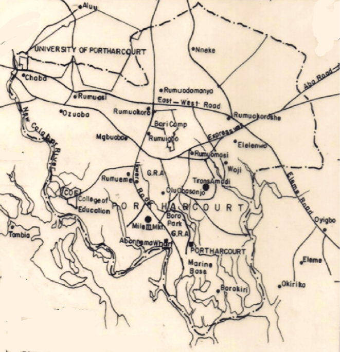
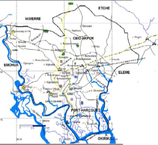
Map of Port Harcourt showing areas Map of Port Harcourt showing major areas
Port Harcourt is the capital of Rivers State, Nigeria and largest city in the state.
It is also the fourth most populous city in Nigeria after Lagos, Kano, and Ibadan.
Founded 1912
Port Harcourt was founded in 1912 by Frederick Lugard, governor of Nigeria.
Purpose The colonial administration of Nigeria created the port to export coal from the collieries of Enugu located 243 kilometres (151 mi) north of Port Harcourt, to which it was linked by a railway.
Name The port was built in 1912, but not given a name until August 1913, when the then Governor of Nigeria, Sir Frederick Lugard, named it “Port Harcourt” in honor of Lewis Harcourt, then the Secretary of State for the Colonies.
Composition The urban area (Port Harcourt metropolis) is made up of the local government area itself and parts of Obio-Akpor and Eleme.
The Greater Port Harcourt region, spans eight local government areas that include Port Harcourt, Okrika, Obio-Akpor, Ikwerre, Oyigbo, Ogu–Bolo, Etche and Eleme.
Some of Port Harcourt’s more popular and well-known residential areas are known as Port Harcourt Township (or just “Town”), GRA (Government Reserved Area) phases 1–5, Elekahia, Rumuomasi, D-line, Elelenwo, Eliozu, Iboloji, Ogbunabali, Rumuola, Rumigbo, Mgbuoba, Diobu, Woji, Amadi Flats, Umuchitta, Rumuokoro and Borikiri.
The main industrial area is located in Trans Amadi, Abuloma.
Location Port Harcourt lies along the Bonny River and is located in the Niger Delta.
Rivers state is located in southern Nigeria, comprising the Niger River delta on the Gulf of Guinea.
Boundaries It is bounded by the states of Anambra and Imo on the north, Abia and Akwa Ibom on the east, and Bayelsa and Delta on the west
How Port Harcourt got its name Port Harcourt named after Lewis Vernon Harcourt.Mr Harcourt was the British Secretary of State for the Colonies. In August 1913,…
Zip codes for Port Harcourt Port Harcourt zip codes or postcodes range from 500001 to 500272. The codes are: AreaZipcodeAbuloma500101Amadio-Ama500101Boibu-Oromerizemgbu500101Elekohia500101Okuru500101Orada Diobu500101Orogbum500101Oroworukwo500101Rainbow Location500101Rumuoparali500101Runiu Kalgbo500101 Port Harcourt…
Nigeria postal code, Port Harcourt Port Harcourt post codes range from 500001 to 500272. The codes are: AreaZipcodeAbuloma500101Amadio-Ama500101Boibu-Oromerizemgbu500101Elekohia500101Okuru500101Orada Diobu500101Orogbum500101Oroworukwo500101Rainbow Location500101Rumuoparali500101Runiu Kalgbo500101 Port Harcourt City Amadi…
GIFMIS Code for FPO PORT HARCOURT The GIFMIS Code for FPO PORT HARCOURT is: SNREVENUE NUMBERREVENUE ITEM DESCRIPTION11000100022REFUND Reference: gifmis.gov.ng/grr-number/ GIFMIS Government Integrated Financial Management Information…
Port Harcourt Port Harcourt is the capital of Rivers State, Nigeria and largest city in the state. It is also the fourth…
Healthcare providers in PORT HARCOURT A list of hospitals, clinics, medical centres and other healthcare facilities and providers in PORT HARCOURT, Rivers State, Nigeria F.S.P.…
Port Harcourt International Airport Port Harcourt International Airport (PHIA) (IATA: PHC, ICAO: DNPO) is an international airport located in Omagwa, a suburb of Port Harcourt,the…
NPC Port Harcourt office address The office address of NPC (National Population Commission) in Port Harcourt RiversNational Population Commission, No 10 Moscow Rd, Port Harcourt.…
 Nigeria")


 Market and Fruit Garden Market, Port Harcourt")


")


