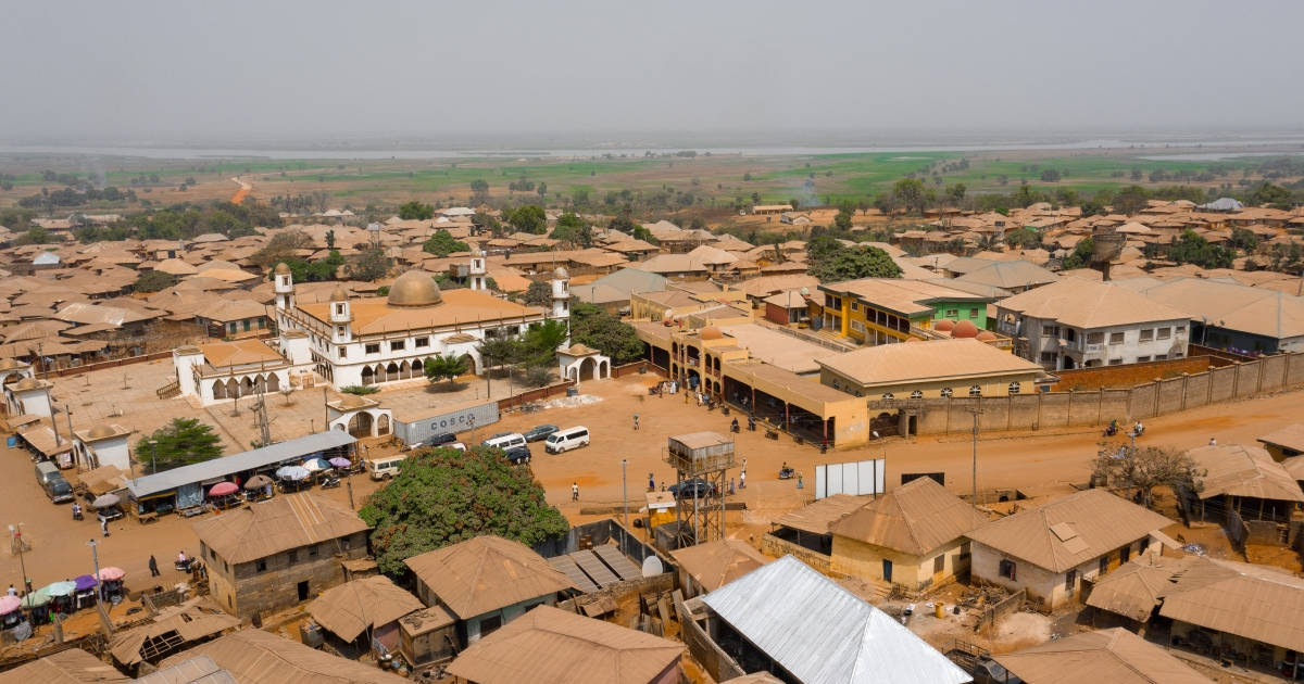
The road distance from Illorin (the Kwara State Capital) to Owu-Isin (the headquarters of Owu-Isin LGA) is 72km.
Isin, a Local Government Area in Kwara State, Nigeria, was created from the old Irepodun Local Government Area in 1996 with the headquarters at Owu-Isin, The Local Government has 11 wards.
Major Towns: Isanlu-Isin, Ijara-Isin, Edidi, Oke-Onigbin, Iwo, Owu, Olla, Alla, Oke Aba, Odo Eku, Opanda, Kudu, Oke-Oyi.
Important Markets: Isanlu-Isin, Owu, Edidi, Oke-Onigbin.
Major Languages: Yoruba.
Major Resources: Cocoa, Plantain, Yam, Maize, Corn.
Mineral Resources: Granite, Clay, Kaolin, Talc, Quartizite, Tormalio, Mia, Tantalite, Precious Stone, Feldspar and Marble.
Major Festivals: Agbasin (Isanlu-Isin), Egungun.
Tourist Attractions: Ijoko Falls, Aise Falls, Atti Falls (Isanlu-Isin), Tii Oye Stone Images, Alaguso Mountain (Ijara Isin), Agbasin Shrine (Isanlu-Isin) Kooyi Shrine (Olla) Alawoji Forest (Iwo).
Hotels and Restaurants: Omolewa Hotels (Isanlu Isin), Dorcas Hotels (Oke-Onigbin), Time Will Tell Hotel, (Iji Isin).
Commercial institutions:
Isanlu-Isin Community Bank, Isanlu-Isin
People’s Bank of Nigeria, Iwo.
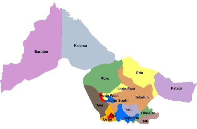
Kwara Local Government Areas
Kwara has 16 Local Government Areas, namely:
Asa
Baruten
Edu
Ekiti
Ifelodun
Ilorin East
Ilorin South
Ilorin West
Irepodun
Isin
Kaiama
Moro
Offa
Oke Ero
Oyun
Pategi
Local Government Areas in Kwara
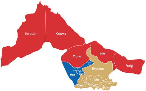
Kwara also has three senatorial districts, six federal constituencies, and 24 state constituencies.
The 3 senatorial districts indicated with colors
More on Kwara
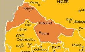
Kwara, a state in western Nigeria, has Ilorin as its capital.
The state was created on 27 May 1967, when the Federal Military Government of General Yakubu Gowon broke the four regions that then constituted the Federation of Nigeria into 12 states.
It is bordered by the states of Niger, Kogi, Ekiti, Osun, and Oyo, as well as the Republic of Benin.
Kwara has a land area of 36,825 square kilometers.
Kwara has several institutions of higher learning, such as the University of Ilorin, Kwara State University, Kwara State Polytechnic, Al-Hikmah University, Landmark University, and Crown Hill University.
The state has many tourist attractions, such as the Esie Museum of Stone Images, the Owu Waterfalls, the Imoleboja Rock Shelter, the Sobi Hill, and the Kainji Lake National Park.
Originally known as the West Central State which then became Kwara State – a local name derived from the Niger River. The State of Harmony as it is fondly called on account of the peaceful relations that exists among its multicultural and diverse population of over 2.5 million people.
Kwara State’s peaceful population, abundant natural resources, well-developed infrastructure and proactive investment-attraction policies have made it an attractive destination for investors.
The principal groups residing in Kwara State are the Yoruba, Nupe, Bariba, and Fulani. The skilled craftsmanship of the people of this central region has been evident for centuries. The most significant and most essential pottery workshops in Nigeria can be found in the capital city of Ilorin.
Proponents of the craft of traditional textile weaving are also very prominent: the Aso Oke style of hand-loomed cloth-making is world-renowned. The Yoruba are the largest population group in the south-western part of Nigeria, while the Fulani comprise a significant proportion of the population of the North.
Former Nigerian president Olusegun Obasanjo is a Yoruba; former president Umaru Yar’Adua was a Fulani. The Yoruba stem from an ancient civilization, the Oyo Empire, that came into existence in the eighth century with its headquarters in Ife, in what is now the neighbouring State of Osun.
Historian Robin Hallett has described the bronze and terracotta works of art known as the Ife heads as one of the ‘supreme artistic achievements of mankind.’ Oyo was at the height of its powers in the middle of the 18th century and was a trade conduit between the south and north.The Nupe Kingdom was located in the North of the Niger River.
According to Hallett, they were ‘industrial specialists,’ with skills including glass-making, weaving, tailoring, blacksmithing, and iron mining. One of the traditional skills of the Nupe is in the making of elaborately carved stools, using only one piece of wood. The Bariba people were once part of the Borgu Kingdom, and about 80% of this group now lives in neighbouring Benin.
The State’s rich and varied culture can be viewed at places such as the Esie Museum, Ogunjokoro, and the Imoleboja Rock Shelter. The Pategi regatta is a popular attraction, with boat owners proudly displaying their vessels and fishing and swimming contests. The Esie stone images are an important cultural artifact while various festivals are not only important to local communities but would prove fascinating to visitors.
The Awon and Egungun festivals are just two examples. The tragic end of explorer Mungo Park’s expedition down the Niger River is commemorated at Jebba where his boat is on display, and there is a monument.
Road distance from the Illorin to Kaiama The road distance From the Illorin (the state capital) to Kaiama (Local Government Headquarters) is 112km. Kaiama is a Local Government…
ROAD DISTANCES BETWEEN MINNA AND LOCAL GOVERNMENT HEADQUARTERS IN NIGER STATE The distance, in kilometres, between Minna and Local Government headquarters in Niger State. LG HQLGA NAMEAPPROX. DISTANCE IN KMsAgaieAgaie100AgwaraAgwara484BidaBida85New BussaBorgu324MaikunkeleBosso11.2LemuGbako123Gawu-BabangidaGurara86.4LapaiLapai75KutigiLavun148NaskoMagama217KontagoraKontagora189MokwaMokwa229PaikoPaikoro18KagaraRafi111RijauRijau285KutaShiroro63SulejaSuleja117WushishiWushishi74MasheguMashegu183MunyaSarkin…
Road distance from Ilorin to Bode-Saadu The road distance from Ilorin (Kwara State capital) to Bode-Saadu (Moro LGA Headquarters) is 85km. Moro is a Local Government…
Road distance from Ilorin to Offa Road distance from Ilorin (Kwara State Capital) to Offa town (the headquarters of Offa Local Government Area) is 56km. Offa…
Road distance from Ilorin to Iloffa The road distance from Ilorin (Kwara State Capital) to Iloffa (Oke-Ero LGA headquarters) is 84km. Oke-Ero is a Local Government…
Road distance from Ilorin to Pategi The road distance from Ilorin (Kwara State capital) to Pategi town (the headquarters of Pategi Local Government Area) is 164km.…


 and Fufu (the headquarters of Ilorin South LGA)")


