Australia is divided into 6 states and 10 territories (2 internal + several external).
1. States of Australia
Each state has its own parliament, governor, and premier.
State
Abbrev.
Capital
Population (2024)
Area (km²)
Premier (Party)
New South Wales
NSW
Sydney
8.51M
800,150
Chris Minns (Labor)
Victoria
VIC
Melbourne
7.01M
227,416
Jacinta Allan (Labor)
Queensland
QLD
Brisbane
5.61M
1,729,742
David Crisafulli (Liberal Nat.)
Western Australia
WA
Perth
2.98M
2,527,013
Roger Cook (Labor)
South Australia
SA
Adelaide
1.88M
984,321
Peter Malinauskas (Labor)
Tasmania
TAS
Hobart
576K
68,401
Jeremy Rockliff (Liberal)
2. Internal Territories
Directly governed under federal law (though ACT and NT have local parliaments).
Territory
Capital
Population (2024)
Area (km²)
Chief Minister
Australian Capital Territory (ACT)
Canberra
476K
2,358
Andrew Barr (Labor)
Northern Territory (NT)
Darwin
256K
1,347,791
Lia Finocchiaro (Country Liberal)
Jervis Bay Territory
Jervis Bay Village
405
67
Administered federally
3. External Territories
Mostly small, remote islands. Some have local councils, others are uninhabited.
Norfolk Island – Kingston (Pop. ~2,600), has local council but integrated into NSW.
Christmas Island – Flying Fish Cove (Pop. ~1,900).
Cocos (Keeling) Islands – West Island (Pop. ~550).
Coral Sea Islands – Very small population (only staff on Willis Island).
Ashmore & Cartier Islands – Uninhabited.
Heard Island & McDonald Islands – Uninhabited, sub-Antarctic.
Australian Antarctic Territory – Pop. ~60 (scientists at Davis Station).
4. Former Territories
Central Australia & North Australia (1926–1931) – later merged into today’s NT.
Papua & New Guinea – Australian-administered until independence (1975).
Nauru – Administered until independence (1968).
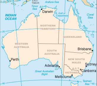
Map of Australia
✅ Key Point:
States have more power (self-governing, entrenched in the Constitution).
Territories are under federal control (powers granted and can be withdrawn).
More
World Heritage Sites in Australia UNESCO World Heritage Sites in Australia are: Great Barrier Reef Kakadu National Park Willandra Lakes Region Lord Howe Island Group…
Bungle Bungles in Western Australia The Bungle Bungles, or Purnululu, are an extraordinary geological formation located in Purnululu National Park in Western Australia’s Kimberley region.…
Nigeria’s 36 States and capital The 36 States and capitals in Nigeria are: Abia (Umuahia) Adamawa (Yola) Akwa Ibom (Uyo) Anambra (Awka) Bauchi (Bauchi) Bayelsa…
Nigeria’s 36 States and Capitals The 36 States of Nigeria and their capitals are: SNStateCapital1AbiaUmuahia2AdamawaYola3Akwa IbomUyo4AnambraAwka5BauchiBauchi6BayelsaYenagoa7BenueMakurdi8BornoMaiduguri9Cross RiverCalabar10DeltaAsaba11EbonyiAbakaliki12EdoBenin City13EkitiAdo-Ekiti14EnuguEnugu15GombeGombe16ImoOwerri17JigawaDutse18KadunaKaduna19KanoKano20KatsinaKatsina21KebbiBirnin Kebbi22KogiLokoja23KwaraIlorin24LagosIkeja25NasarawaLafia26NigerMinna27OgunAbeokuta28OndoAkure29OsunOshogbo30OyoIbadan31PlateauJos32RiversPort Harcourt33SokotoSokoto34TarabaJalingo35YobeDamaturu36ZamfaraGusau List of Nigeria’s 36 states…
List of Nigeria states and capitals The states and capitals of the Federal Republic of Nigeria are: SNStateCapital1AbiaUmuahia2AdamawaYola3Akwa IbomUyo4AnambraAwka5BauchiBauchi6BayelsaYenagoa7BenueMakurdi8BornoMaiduguri9Cross RiverCalabar10DeltaAsaba11EbonyiAbakaliki12EdoBenin City13EkitiAdo-Ekiti14EnuguEnugu15GombeGombe16ImoOwerri17JigawaDutse18KadunaKaduna19KanoKano20KatsinaKatsina21KebbiBirnin Kebbi22KogiLokoja23KwaraIlorin24LagosIkeja25NasarawaLafia26NigerMinna27OgunAbeokuta28OndoAkure29OsunOshogbo30OyoIbadan31PlateauJos32RiversPort Harcourt33SokotoSokoto34TarabaJalingo35YobeDamaturu36ZamfaraGusau Federal territory (similar…
Nigeria states and capitals, population, land area States of Nigeria; their capitals, population, land and area in Km² StateCapitalPopulationArea (Km²)AbiaUmuahia2,833,9994,857AdamawaYola3,168,10137,957Akwa IbomUyo3,920,2086,788AnambraAwka4,182,0324,761BauchiBauchi4,676,46548,197BayelsaYenagoa1,703,3589,363BenueMakurdi4,219,24430,755BornoMaiduguri4,151,19372,767Cross RiverCalabar2,888,96622,112DeltaAsaba4,098,39117,095EbonyiAbakaliki2,173,5016,342EdoBenin City3,218,33219,584EkitiAdo-Ekiti2,384,2125,797EnuguEnugu3,257,2987,560Federal Capital TerritoryAbuja1,405,2017,569GombeGombe2,353,87917,428ImoOwerri3,934,8995,135JigawaDutse4,348,64923,415KadunaKaduna6,066,56244,217KanoKano9,383,68220,389KatsinaKatsina5,792,57823,822KebbiBirnin Kebbi3,238,62836,320KogiLokoja3,278,48729,063KwaraIlorin2,371,08933,792LagosIkeja9,013,5343,475NasarawaLafia1,863,27526,633NigerMinna3,950,24972,065OgunAbeokuta3,728,09816,850OndoAkure3,441,02415,019OsunOshogbo3,423,5358,585OyoIbadan5,591,58927,036PlateauJos3,178,71226,539RiversPort Harcourt5,185,40010,361SokotoSokoto3,696,99932,146TarabaJalingo2,300,73659,180YobeDamaturu2,321,59144,880ZamfaraGusau3,259,84633,667Total140,003,542911,519…
How and when states were created in Nigeria List of Nigeria’s 36 states and the Federal Capital Territory AbiaAdamawaAkwa IbomAnambraBauchiBayelsaBenueBornoCross RiverDeltaEbonyiEdoEkitiEnuguFederal Capital Territory, AbujaGombeImoJigawaKadunaKanoKatsinaKebbiKogiKwaraLagosNasarawaNigerOgunOndoOsunOyoPlateauRiversSokotoTarabaYobeZamfara By the time that…
List of states in Nigeria with dates of creation and names of presidents at the time of creation List of Nigeria’s 36 states and the Federal Capital Territory AbiaAdamawaAkwa IbomAnambraBauchiBayelsaBenueBornoCross RiverDeltaEbonyiEdoEkitiEnuguFederal Capital Territory, AbujaGombeImoJigawaKadunaKanoKatsinaKebbiKogiKwaraLagosNasarawaNigerOgunOndoOsunOyoPlateauRiversSokotoTarabaYobeZamfara List of 5 states…
Names and meanings of US states Names of the states of US (United States) and the meanings Alabama: from Alabama River, from an ethnic name Alaska:…
NPC office addresses in 36 States and Abuja The offices addresses of NPC (National Population Commission) in 36 States and Abuja AbiaNational Population Commission, Uzafather Rd, Aba roundabout,…


 offices and addresses in 36 States and Abuja")


 IN BAUCHI AND YOBE STATES")
, State Capitals, Land Area, Population, GDP, Subdivisions (Districts, Cities and Municipalities)")

