A look at five Yoruba sub-ethnic groups in Oyo State
The people of Oyo State are Yoruba with a common ancestor, Oduduwa. However, there are sub-ethnic groups with distinct dialect peculiarities.
The people of Oyo State may be divided into five broad groups, namely: Ibadans, Ibarapas, Oyos, Oke-Oguns and Ogbomosos.
IBADANS
The Ibadans have their settlements in the city of Ibadan and surrounding farms and villages. They trace their roots to Lagelu, a warrior. The city grew around a legendary baobab tree from which it derived its name. It grew quickly, attracting warriors and refugees from the internecine wars that raged Yorubaland in the 18th century. Over the years, the diverse background of the early settlers has evolved into a sub-cultural mix that is unique in Yorubaland. The system of promotion from Compound Head (Mogaji) to the throne is exclusive to the Ibadans. The people are spared the unhealthy rivalry and in-fighting that attends filling of vacant stools. The people were originally warriors and farmers but are now gainfully employed in all areas of human endeavour.
OYOS
The Oyos occupy a geographic location to the north of Ibadan including Oyo town, surrounding towns and villages. In ancient times, Oyo Empire ruled over a sizeable chunk of Yorubaland and beyond. The Oyos were core people of the Oyo Empire. Today, the Empire is no more, but the people retain their proud heritage. They are engaged in all forms of modern business activities and human endeavours. Oyo State is named after the rich heritage of the people.
OGBOMOSOS
The Ogbomosos dwell in the town of that name and surrounding towns and villages. The people have their home on the strategic route linking the northern parts of Nigeria to the south. In times past, they were fearless warriors. They have many things in common with the Oyos in particular and other sub-cultural groups in Yorubaland. Today, the people are established in all areas of modern business and public service. They are renowned traders, and can be located in any part of the country conducting their businesses. They are established all over Northern Nigeria and the West African sub-region.
IBARAPAS
The Ibarapas are scattered over seven major towns and surrounding villages. The towns are: Eruwa, Tapa, Ayete, Igbo-Ora, Lanlate, Igangan and Idere. The Ibarapas have a distinct dialect that separates them from their nearest neighbours. The people have similarities with the Oyos. The people are mainly farmers. Yam and cassava flour (elubo) are major farm products in the area. They also engage in plantation farming-cultivating cocoa and palm produce.
OKE-OGUNS
The Oke-Oguns occupy the guinea savannah area of Oyo State. Many sources ascribe same origin to the Oke-Ogun people and the Oyos. The people are scattered over several towns and villages, namely Iseyin, Saki, Okeho, Igbeti and Igboho, among others. The people are hardworking and hospitable. The people of Oke-Ogun are mainly farmers. The area is tagged the “Food basket” of Oyo State. Weaving and pottery are cottage industries well developed among the people. The people are noted for their business acumen.
Reference: oyostate.gov.ng/about-oyo-state
Oyo State
Oyo is a state in Nigeria. It covers a total of 28,454 square kilometres of land mass and it is bounded in the south by Ogun State, in the north by Kwara State, in the west it is partly bounded by Ogun State and partly by the Republic of Benin, while in the East by Osun State.
YEAR FOUNDED: 1976
Located in the South-West geopolitical zone of Nigeria, Oyo State was one of the three States carved out of the former Western State of Nigeria in 1976.
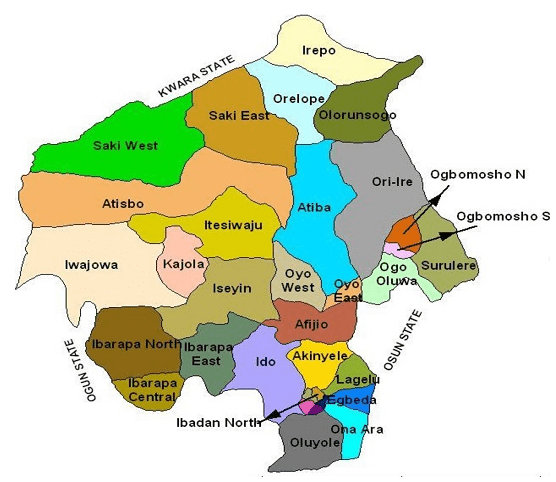
33 Local Governments Areas
Oyo State consists of 33 Local Governments and 29 Local Council Development Areas. Local Government Areas are: Afijio, Akinyele, Atiba, Atisbo, Egbeda, Ibadan North, Ibadan North-East, Ibadan North-West, Ibadan South-East, Ibadan South West, Ibarapa Central, Ibarapa East, Ibarapa North, Ido, Irepo, Iseyin, Itesiwaju, Iwajowa, Kajola, Lagelu, Ogbomoso North, Ogbomoso South, Ogo-Oluwa, Olorunsogo,Oluyole, Ona-Ara, Oorelope, Oriire, Oyo East, Oyo West, Saki East, Saki West and Surulere.
29 Local Council Development Areas
The Local Council Development Areas (LCDAs) are: Aare Latosa, Afijio West, Ajorosun, Akinyele East, Akinyele South, Akinyele West, Akorede, Araromi, Atisbo South, Ibadan East, Ibadan South East, Ibadan West, Ibarapa North-East, Ibarapa North-West, Ifeloju, Iganna, Inukan, Irepodun, Iseyin South, Iwa, Lagelu North, Ogbomoso Central, Ogbomoso South-West, Ogo-oluwa West, Oke’badan, Omi Apata, Surulere North, Surulere South, Wewe.
Topography
The topography of the State is of gentle rolling low land in the south, rising to a plateau of about 40metres. The State is well drained with rivers flowing from the upland in the north-south direction.
The landscape consists of old hard rocks and dome shaped hills, which rise gently from about 500 meters in the southern part and reaching a height of about 1,219 metres above sea level in the northern part.
Climate
Oyo State has an equatorial climate with dry and wet seasons and relatively high humidity. The dry season lasts from November to March while the wet season starts from April and ends in October. Average daily temperature ranges between 25 °C (77.0 °F) and 35 °C (95.0 °F), almost throughout the year. The vegetation pattern of Oyo State is that of rain forest in the south and guinea savannah in the north. Thick forest in the south gives way to grassland interspersed with trees in the north.
Agriculture
The climate in the State favours the cultivation of crops like Maize, Yam, Cassava, Millet, Rice, Plantain, Cocoa tree, Palm tree and Cashew. There are a number of Government Farm Settlements in Ipapo, Ilora, Sepeteri, Eruwa, Ogbomosho, Iresaadu, Ijaiye, Akufo and Lalupon.
Oyo State NYSC orientation camp address The address of the NYSC orientation camp in Oyo State is: Government Technical College, Iseyin Local Government Area, Iseyin, Oyo…
PEOPLE OF OYO STATE, NIGERIA The people of Oyo State are Yoruba with a common ancestor, Oduduwa. Within Oyo State however, there are sub-ethnic groups…
POLITICAL ZONES IN OYO STATE The State is divided into three Senatorial Districts of Oyo North, Oyo Central and Oyo South. Oyo North has 13…
Geography of Oyo State Oyo State is located in the South West Region of Nigeria. Latitude 8 degree and Longitude 4 degree East bisect…
History of Oyo State leadership Oyo State, popularly referred to as the “Pace Setter” is one of the constituent 36 States of the Federal Republic…
ABOUT OYO STATE Oyo State was created in February 1976 as a result of the creation of three States out of the former…
LGA in Oyo State The LGAs (Local Government Areas) in Oyo State, Nigeria are: Afijio Akinyele Atiba Atisbo Egbeda Ibadan North Ibadan North East…
Largest Local Government Areas in Oyo State by land area 10 largest Local Government Areas by land area in Oyo State of Nigeria are: AtisboIwajowaOri IreSaki WestAtibaSaki EastItesiwajuIseyinIbarapa NorthOlorunsogo LARGE. List…
Largest Local Government Areas in Oyo State by population 10 most populated Local Government Areas in Oyo State of Nigeria are: AfijioAkinyeleAtisboAtibaEgbedaIbarapa EastIbadan NorthIbarapa CentralIdoIbadan South East LARGE. List…
List of Local Government Areas in Oyo State and their headquarters Oyo State Local Government Areas and their headquarters, administrative capitals LGAHeadquartersAfijioJobeleAkinyeleMoniyaAtisboTedeAtibaOfa MefaEgbedaEgbedaIbarapa EastEruwaIbadan NorthAgodiIbarapa CentralIgbo OraIdoIdoIbadan South EastMapo hallIwajowaIwere IleIbadan…