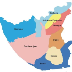
Nembe local Government Area occupies the south eastern flank of the State.
Its southern border which forms part of the Bayelsa Coastline provides for the estuaries of the St, Nicholas, and Santa Babara Rivers emptying into the Atlantic Ocean.
It also comprises of Nembe East, Mini-Ikensi and Okoroma-Tekere local government areas.
It occupies 9.4% of the total land area, and holds 13.7% of the total population of Bayelsa.Nembe has numerous meandering creeks which are rich in fishery resources and a rich array of mangrove forest that are home to diverse plant and animal species.
The area is also blessed with cultivable land, food and cash crops as well as agro-based raw materials and natural minerals.
The traditional occupations of the people include fishing, trading, lumbering and wood sawing, canoe carving, weaving, and salt production.


