Kebbi State was created out of the old Sokoto State in 1991 and it is located within latitudes 10.12°E and 13.29°N and longitudes 3.56°N and 6.06°E, covering a land area of 36,653km².
It is bordered to the west by Benin and Niger Republics, to the east by Sokoto and Zamfara States, to the south by Zamfara and to the north by Sokoto State.
The State has two geological formations: Precambrian basement complex in the South and South-East which are volcanic and metamorphic in nature; and young sedimentary rocks in the North.
The altitude varies between 148-495m above sea level. The State experiences the Tropical Continental Climate where mean annual temperature is 26°C, with annual temperature range of 21°C to 42°C and annual total rainfall is about 750mm.
Rains begins in May/June and lasts till October/November, after which the cold period sets in when the lowest temperature for the year is experienced.
The dry season lasts between November and May of the following year, and the peak of temperature is experienced in April/May. The State is largely drained by the Rivers Niger and Rima together with their tributaries.
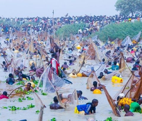
Argungu fishing festival in Kebbi State
It is largely spread within the Sudan Savannah vegetation zone where locust bean tree (Parkia biglobosa), Shea Butter tree (Vitellaria paradoxa), bushwillows (combretum) grow.
The natural vegetation which is woodland has grossly been altered by myriads of human activities resulting from high population growth.
Dominant soils include acrisols, leptosols, arenosols and fluvisois. These are well drained and good for agriculture.
Borno Geography, Economy, History, and Culture Borno is a notable state in northeastern Nigeria, known for its diverse landscape, significant agricultural activities, and strategic geographic positioning.…
Geography of Benin Republic Benin is located in West Africa in the tropical zone between the equator and the Tropic of Cancer (between the…
Geography of Oyo State Oyo State is located in the South West Region of Nigeria. Latitude 8 degree and Longitude 4 degree East bisect…
Geography of Nasarawa State The general topography of Nasarawa State is that of hills/ dissected terrain, undulating plains and lowlands. A look at the…
GEOGRAPHY OF ABUJA Abuja is located in the centre of Nigeria and has a land area of 8,000 square Kilometers. It is bounded…
GIFMIS Code for Federal University Birnin-Kebbi The GIFMIS Codes for Federal University Birnin-Kebbi are: SNREVENUE NUMBERREVENUE ITEM DESCRIPTION1100003873Contractor Registration Fees21000089224Undergraduate Fees31000089237Utility Bills41000089253SBS Registration Fees51000089266Post UTME Screening…
GIFMIS Code for Federal Medical Centre, Birnin-Kebbi The GIFMIS Codes for Federal Medical Centre, Birnin-Kebbi are: SNREVENUE NUMBERREVENUE ITEM DESCRIPTION11000063127Drugs and Revolving Fund21000063130Laboratory Revolving Fund31000063143Hospital Service Revolving…
Kebbi State NYSC orientation camp address The address of the NYSC orientation camp in Kebbi State is: NYSC Permanent Orientation Camp, Dakingari Local Government Area, Kebbi…
KEBBI HOUSE OF ASSEMBLY, 2006 The Kebbi State House of Assembly comprises 24 members. LIST OF HONOURABLE MEMBERS OF KEBBI STATE HOUSE OF ASSEMBLY, 2006…
Kebbi Kebbi, a state in Nigeria, was created on 27th August, 1991, out of the then Sokoto State, following the creation…
LGA in Kebbi State The LGAs (Local Government Areas) in Kebbi State, Nigeria are: Aleiro Arewa-Dandi Argungu Augie Bagudo Birnin Kebbi Bunza Dandi Fakai…
Largest Local Government Areas in Kebbi State by land area 10 largest Local Government Areas by land area in Kebbi State of Nigeria are: BagudoWasagu/DankoArewa-DandiNgaskiFakaiDandiShangaYauriSuruBirnin Kebbi LARGE. List of LGAs in…
Largest Local Government Areas in Kebbi State by population 10 most populated Local Government Areas in Kebbi State of Nigeria are: Birnin KebbiWasagu/DankoBagudoArgunguJegaArewa-DandiMaiyamaZuruKoko/BesseGwandu LARGE. List of LGAs in Kebbi…
List of Local Government Areas in Kebbi State and their headquarters Kebbi State Local Government Areas and their headquarters, administrative capitals LGAHeadquartersArewa-DandiArewa DandiAleiroAleiroArgunguArgunguAugieAugieBagudoBagudoBirnin KebbiBirnin KebbiBunzaBunzaDandiKambaFakaiMahutaGwanduGwanduJegaJegaKalgoKalgoKoko/BesseKoko/BesseMaiyamaMaiyamaNgaskiWaraSakabaSakabaShangaShangaSuruDakingariWasagu/DankoRibahYauriYelwaZuruZuru Map of Kebbi State showing Local…


 with History, Geography & Culture")


