Sinai Peninsula: Crossroads of Geography, Culture, and History
The Sinai Peninsula, often called the land bridge between Africa and Asia, is a strikingly unique region nestled in northeastern Egypt. Spanning approximately 61,000 square kilometers—about 6% of Egypt’s total land area—it serves as a rich tapestry of ancient history, dramatic landscapes, and cultural heritage.
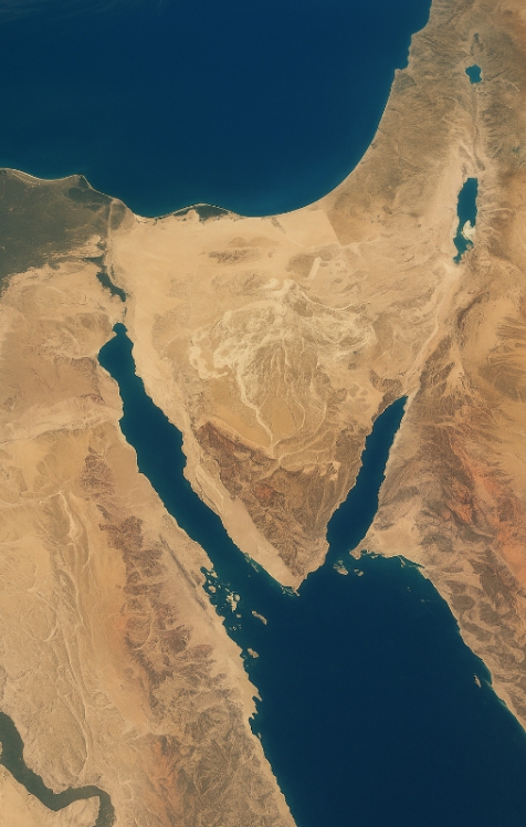
Triangular in shape, its broad base faces north toward the Mediterranean, while its pointed tip stretches south toward the Red Sea. From religious pilgrimages to eco-tourism and ancient trade routes, Sinai’s importance stretches far beyond its geographic footprint.
Geographical Boundaries and Natural Features
The Mediterranean Coast
Northern Sinai meets the Mediterranean Sea with a long stretch of relatively flat, fertile land. This coastal region enjoys seasonal rainfall, fostering agriculture and supporting coastal towns like El-Arish.
Gulf of Aqaba and Gulf of Suez
Flanking the peninsula on its east and west are the Gulf of Aqaba and Gulf of Suez, respectively. These bodies of water are not only stunningly scenic but also crucial maritime routes and diving hotspots.
Suez Canal Connection
The western edge of Sinai connects to mainland Egypt via the Suez Canal—a globally significant waterway that links the Red Sea to the Mediterranean Sea. This enhances the peninsula’s strategic and economic value.
Terrain and Landscape
Sinai’s landscape varies drastically from north to south, creating three distinct regions.
Southern Sinai: Rugged Mountain Ranges
This section is defined by dramatic granite peaks, deep wadis (valleys), and canyons. It’s home to Mount Catherine, Egypt’s tallest mountain at 2,637 meters. The rough terrain has protected many ancient sites and ecosystems.
Central Sinai: The at-Teeh Plateau
Known as the at-Teeh Plateau, this central zone features highlands where valleys slope gently northward. Historically significant as part of ancient migration and biblical paths, it’s also known for its expansive deserts.
Northern Sinai: Fertile Coastal Plains
Flatter and greener, this area benefits from runoff from the central and southern highlands. Seasonal rainfall enriches the soil, supporting limited agriculture and small communities.
Mount Catherine: The Peak of Egypt
Towering above the southern range, Mount Catherine is not only Egypt’s highest peak but also a spiritual site believed to be near the biblical Mount Sinai. Pilgrims and hikers alike visit for sunrise treks and reflective retreats.
Climate and Water Resources
Sinai’s climate ranges from coastal Mediterranean to harsh desert. The north sees more rainfall, especially in winter, while the south is arid year-round. Water sources include rain catchments, springs, and limited underground aquifers.
Historical and Religious Significance
Sinai is deeply woven into the stories of Judaism, Christianity, and Islam. The Monastery of Saint Catherine, a UNESCO World Heritage Site, has stood for centuries at the foot of Mount Sinai. Many believe this is where Moses received the Ten Commandments.
Cultural Diversity of Sinai
The peninsula is home to various Bedouin tribes, each with rich oral traditions, nomadic practices, and deep environmental knowledge. These communities speak Arabic dialects and maintain cultural identities distinct from mainland Egypt.
Economic Activities in Sinai
Tourism
Destinations like Sharm El Sheikh, Dahab, and Taba attract millions of tourists annually for snorkeling, diving, and hiking.
Mining and Natural Resources
Sinai hosts quarries and mines rich in minerals such as manganese, limestone, and turquoise—resources that have been mined since ancient Egyptian times.
Agriculture and Fishing
In northern Sinai, farmers grow olives, dates, and vegetables. Fishing along the coasts adds to local economies.
More
Borno Geography, Economy, History, and Culture Borno is a notable state in northeastern Nigeria, known for its diverse landscape, significant agricultural activities, and strategic geographic positioning.…
Kebbi geography The geography of Kebbi State, Nigeria Kebbi State was created out of the old Sokoto State in 1991 and it…
GEOGRAPHY OF ABUJA Abuja is located in the centre of Nigeria and has a land area of 8,000 square Kilometers. It is bounded…
Geography of Nasarawa State The general topography of Nasarawa State is that of hills/ dissected terrain, undulating plains and lowlands. A look at the…
Geography of Oyo State Oyo State is located in the South West Region of Nigeria. Latitude 8 degree and Longitude 4 degree East bisect…

 with History, Geography & Culture")

 Community in Warri North Local Government Area, Delta State: A People at the Crossroads of Rich Heritage and Existential Challenges")


