Jigawa State, established in August 1991 from the former Kano State, is among Nigeria’s 36 states. It lies in the northwestern part of the country and is characterized by a unique mix of cultural heritage, agricultural potential, and environmental diversity. With an international border adjoining the Republic of Niger, Jigawa has developed into a hub of cross-border trade and economic opportunity. This article provides a comprehensive look at the state’s geography, demography, climate, governance, and socio-economic fabric.
Geographical Location
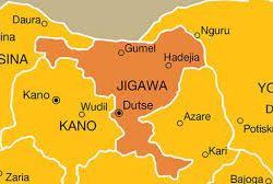
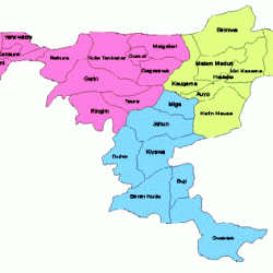
Jigawa State is situated between latitudes 11.00° N to 13.00° N and longitudes 8.00° E to 10.15° E. It borders Kano and Katsina to the west, Bauchi to the east, and Yobe to the northeast, with a northern boundary adjoining the Republic of Niger. This strategic location offers Jigawa significant trade prospects, especially through the Maigatari Free Trade Zone established along its border with Niger.
Historical Background and Formation
Jigawa State was carved out of Kano State in August 1991 as part of Nigeria’s state reorganization efforts. With 27 Local Government Councils, the state is divided into 30 constituencies, grouped into 11 federal constituencies and three senatorial districts. The state’s administrative structure aligns with Nigeria’s 1999 Constitution, providing local and federal representation for Jigawa’s residents.

Economic Potential and Cross-Border Trade
The proximity to Niger enhances Jigawa’s economic potential, providing opportunities for the exchange of goods and services between Nigeria and neighboring countries. The Maigatari Free Trade Zone attracts both local and international investors, driving growth in sectors like agriculture, manufacturing, and trade. Government policies support cross-border trade by simplifying regulations, enhancing infrastructure, and offering tax incentives for businesses in the Free Trade Zone.
Topography
Jigawa’s terrain spans 24,742 square kilometers and is largely characterized by undulating land with sand dunes. The southern parts of the state lie on the Basement Complex, while the northeast features sedimentary Chad Formation rocks. The state’s rivers, including Hadejia, Kafin Hausa, and Iggi, provide vital water sources that nourish the region’s agriculture and support local ecosystems.
Hydrology and River Systems
The Hadejia-Kafin Hausa River traverses Jigawa from west to east, supporting extensive wetlands in the northeastern area. These wetlands, part of the Hadejia-Nguru ecosystem, are crucial for regional biodiversity and play a role in replenishing the Lake Chad Basin. Tributaries of these rivers feed marshlands that provide habitats for various species and support fishing activities among the local population.
Climate
Jigawa experiences a tropical climate divided into two main seasons: the rainy season, spanning May to September, and the harmattan dry season, lasting from November to April. Temperatures vary from as low as 11°C during harmattan nights to highs around 40°C in the hotter months. Annual rainfall averages around 650mm, with higher precipitation occurring in the southwestern areas. Seasonal climate fluctuations significantly affect agricultural cycles, water resources, and daily life in the state.
Vegetation and Environmental Challenges
Jigawa’s vegetation primarily consists of Sudan Savannah with patches of Guinea Savannah in the south. However, deforestation and desertification pose serious environmental challenges, particularly in northern areas vulnerable to Sahara Desert encroachment. Efforts to counter forest depletion include afforestation projects and sustainable agricultural practices to maintain the state’s rich soil and arable land.
Agricultural Potential
Jigawa’s fertile soil and climate make it highly suitable for a variety of tropical crops. The extensive arable land offers promising conditions for both subsistence and commercial agriculture. Key crops include millet, sorghum, maize, rice, and cotton. Government initiatives are in place to enhance agricultural productivity and market access, especially for smallholder farmers who form the backbone of the state’s rural economy.
Population Dynamics
Jigawa has an estimated population of 6.5 million people, with projections indicating continued growth. A 2016 report estimated that 90% of the population resides in rural areas. The gender distribution is nearly equal, with 50.8% male and 49.2% female. Jigawa’s demographics reflect a relatively young population structure, with high fertility rates contributing to rapid population growth.
Life Expectancy and Fertility Rate
The life expectancy in Jigawa stands at approximately 47.8 years for males and 48.5 years for females, one of the lowest in Nigeria. Contributing factors include limited healthcare facilities, poverty, and high rates of maternal and infant mortality. The fertility rate is among the country’s highest, with an average of 8.5 children per woman, indicating a need for more robust family planning and maternal health services.
Ethnic and Cultural Composition
Jigawa is predominantly inhabited by Hausa/Fulani, with Kanuri and Badawa communities also present, especially in the Hadejia Emirate. Islam serves as a unifying religion for these groups, fostering social cohesion and facilitating inter-ethnic marriages. The rich cultural heritage, seen in festivals, attire, and social customs, continues to thrive amid modernization.
Government Structure
Jigawa operates under a democratic government system, with elected officials at both state and local levels. The state’s unicameral legislature consists of 30 members representing each constituency. A State Executive, headed by the governor, administers policies and oversees development programs, while an independent judiciary ensures justice and law enforcement.
Local Government and Administrative Divisions
The state’s 27 Local Government Areas are further divided into various administrative zones. These councils facilitate governance at the grassroots level, ensuring that development projects and social services reach even the most remote parts of the state. The councils work closely with state ministries to implement policies tailored to each locality’s needs.
State Ministries and Parastatals
The state government’s executive functions are carried out through various ministries and parastatals, including the Ministry of Education, Water Agencies, and Jigawa Agricultural and Rural Development Authority (JARDA). These agencies, with zonal offices across the senatorial districts, oversee development projects in agriculture, health, water supply, and education, contributing to socio-economic growth.
Socio-Cultural and Religious Dynamics
Islam is the predominant religion in Jigawa, influencing both social and cultural practices. Hausa/Fulani, Kanuri, and Badawa communities maintain their ethnic identities while sharing common religious beliefs and practices. The state’s cultural festivals, traditional attire, and family customs reflect a harmonious blend of tradition and modernity.
- What is the geographic significance of Jigawa State?
- Jigawa’s location near Niger facilitates trade and cultural exchanges, supported by the Maigatari Free Trade Zone.
- What are the main environmental issues in Jigawa State?
- Jigawa faces challenges like deforestation, desertification, and declining forest cover, particularly in northern areas.
- How does Jigawa’s climate affect agriculture?
- The state’s tropical climate with distinct rainy and dry seasons influences the farming calendar, affecting crop yield and food production.
- What is the population of Jigawa State?
- The population is approximately 6.5 million, predominantly rural, with a high fertility rate contributing to rapid growth.
- What are Jigawa’s main agricultural products?
- Key crops include millet, sorghum, maize, rice, and cotton, supported by fertile soil and favorable climatic conditions.
- How is Jigawa State governed?
- Jigawa has a democratic government with elected officials at both state and local levels, comprising an executive, legislature, and judiciary.
