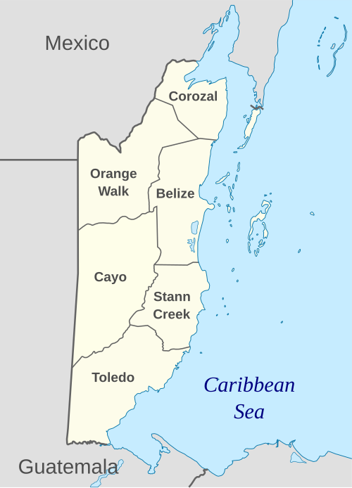
Belize is divided into six main administrative districts. These districts serve as the highest-level subdivisions for statistical, judicial, and administrative purposes (though day-to-day local governance is handled lower down).
Here are the six districts and the capitals:
District
Capital (District Seat)
Belize District
Belize City
Cayo District
San Ignacio
Corozal District
Corozal Town
Orange Walk District
Orange Walk Town
Stann Creek District
Dangriga
Toledo District
Punta Gorda
Role of Districts vs Local Government Structure
While the six districts form the primary administrative/geographic divisions, they are not themselves units of local government in the sense of municipal governance: they are used for census, judicial jurisdiction, and broader administrative classification.
Local governance is implemented at sub-district levels — through municipalities for urban areas, and village/community authorities for rural sectors.
Municipal & Rural Governance Entities
Cities & Towns: There are two city councils and seven town councils in Belize.
City councils: Belize City Council (in Belize City) and Belmopan City Council (in the national capital, which lies within Cayo District).
Town councils manage urban centers in towns across the districts (e.g. San Ignacio, Corozal Town, Orange Walk Town, Dangriga, Punta Gorda, Benque Viejo del Carmen, San Pedro).
Council composition: typically a mayor and several councillors (e.g. ten in Belize City, six in other municipalities).
These municipal bodies oversee urban services — such as street maintenance and lighting, drains, waste collection, public cemeteries, markets, infrastructure, public buildings, and more.
Village & Community Councils: Rural areas are handled by village or community councils — there are over 180 village councils and some number of community councils nationwide.
Village status typically requires a minimum number of registered voters; councils hold periodic meetings and can form committees for community projects.
Their role: encourage and coordinate social and economic development, general welfare, community-level services; sometimes advisory to the national government.
Traditional-Authority System (Alcaldes): In certain rural and indigenous communities — especially in the south (e.g. in Toledo District) — a traditional-authority system operates alongside village/community councils. The local leader (alcalde) has both administrative and judicial functions: managing communal land, presiding over local courts, and acting as a school officer or local magistrate.
Constituencies and Electoral Representation
The six districts are subdivided further into 31 electoral constituencies (electoral divisions), used for national parliamentary representation.
The distribution of constituencies reflects population and geographic considerations. For instance:
The Belize District has 10 constituencies (with about one-third of the national population).
The Cayo District has six constituencies.
The more sparsely populated districts have fewer constituencies (e.g. two each for some southern districts).
These constituencies ensure that even areas within the same district get proportional representation based on population.
Why the District Structure Matters — But Isn’t the Base for Governance
The six-district division provides a consistent framework for statistical data collection, nationwide planning, and judicial boundaries.
However, governance and public services are decentralized: The actual delivery — urban planning, sanitation, community development — is entrusted to city/town councils, village/community councils, and (in some areas) traditional authorities (alcaldes).
This layered approach allows governance to be more locally responsive: rural villages can manage their immediate needs, towns manage municipalities, and traditional communities maintain customary legal and communal land systems.
Belize’s six-district structure — Belize, Cayo, Corozal, Orange Walk, Stann Creek, and Toledo — forms the backbone of the country’s administrative geography. Within that framework, actual local governance is handled by a combination of municipal councils (cities/towns), village and community councils, and traditional authority systems (where applicable). Electoral representation is carved out via 31 constituencies distributed across the districts. This layered approach enables a blend of national oversight, local decision-making, and cultural/legal pluralism, reflecting Belize’s diverse population and geography.
More
Ghana districts. Population, size of land area and capitals of districts The districts of Ghana and their population, land area and capitals are as follows: DistrictPopulationArea (km.²)CapitalAbura-Asebu-Kwamankese90,093324Abura-DunkwaAccra1,659,136185AccraAdansi East129,3251,380New EdubiaseAdansi West235,680828ObuasiAfigya Sekyere117,653770AgonaAfram…
List of Ghana districts and capitals Ghana districts and capitals are: DistrictCapitalAbura-Asebu-KwamankeseAbura-DunkwaAccraAccraAdansi EastNew EdubiaseAdansi WestObuasiAfigya SekyereAgonaAfram PlainsDonkorkromAgonaSwedruAhafo Ano NorthTepaAhafo Ano SouthMankransoAhanta WestAgona NkwantaAjumako/Enyan/EsiamAjumakoAkatsiAkatsiAkwapim NorthAkropongAkwapim SouthNsawamAmansie EastBekwaiAmansie…
List of Tanzania districts and capitals The districts of Tanzania and their capitals are: DistrictCapitalArumeruAkheriArushaArushaBabatiBabatiBagamoyoChalinzeBariadiBariadiBiharamuloBiharamulo MjiniBukoba RuralBukobaBukoba UrbanBukobaBukombeUshiromboBundaBundaChakeChake ChakeChunyaMakongorosiDodoma RuralDodomaDodoma UrbanDodomaGeitaKalangalalaHaiHai MjiniHanangGananaHandeniChanikaIgungaIgungaIlalaIlalaIlejeItumbaIlemelaIlemelaIrambaSheluiIringa RuralIringaIringa UrbanIringaKahamaKahama MjiniKaragweKayangaKaratuKaratuKaskazini ‘A’MkokotoniKaskazini…
World Heritage Site in Belize UNESCO World Heritage Site in Belize is: Belize Barrier Reef Reserve System > View other UNESCO World Heritage Sites More…
Botswana Districts and their Capitals Botswana’s Administrative District System Botswana is a unitary state whose territorial administration is structured to balance centralized governance with effective…
Tanzania districts: Population, land size and capitals Districts of Tanzania by population, land size and capital DistrictPopulationArea (Km²)CapitalArumeru514,6512,896AkheriArusha281,60883ArushaBabati302,2534,969BabatiBagamoyo228,9679,842ChalinzeBariadi603,6049,777BariadiBiharamulo409,3898,938Biharamulo MjiniBukoba Rural394,0206,993BukobaBukoba Urban80,86880BukobaBukombe395,29810,842UshiromboBunda258,9302,782BundaChake82,998332Chake ChakeChunya205,91527,065MakongorosiDodoma Rural438,86614,004DodomaDodoma Urban322,8112,576DodomaGeita709,0785,880KalangalalaHai258,9352,369Hai MjiniHanang204,6402,918GananaHandeni248,6336,112ChanikaIgunga324,0946,788IgungaIlala634,924210IlalaIleje109,8471,935ItumbaIlemela264,873895IlemelaIramba367,0367,900SheluiIringa Rural245,03319,898IringaIringa Urban106,371160IringaKahama594,8919,461Kahama…
List of Nigeria states and capitals The states and capitals of the Federal Republic of Nigeria are: SNStateCapital1AbiaUmuahia2AdamawaYola3Akwa IbomUyo4AnambraAwka5BauchiBauchi6BayelsaYenagoa7BenueMakurdi8BornoMaiduguri9Cross RiverCalabar10DeltaAsaba11EbonyiAbakaliki12EdoBenin City13EkitiAdo-Ekiti14EnuguEnugu15GombeGombe16ImoOwerri17JigawaDutse18KadunaKaduna19KanoKano20KatsinaKatsina21KebbiBirnin Kebbi22KogiLokoja23KwaraIlorin24LagosIkeja25NasarawaLafia26NigerMinna27OgunAbeokuta28OndoAkure29OsunOshogbo30OyoIbadan31PlateauJos32RiversPort Harcourt33SokotoSokoto34TarabaJalingo35YobeDamaturu36ZamfaraGusau Federal territory (similar…
List of Tanzania regions and capitals The regions of Tanzania and the capitals are: RegionCapitalArushaArushaDar es SalaamDar es SalaamDodomaDodomaGeitaGeitaIringaIringaKageraBukobaKataviMpandaKigomaKigomaKilimanjaroMoshiLindiLindiManyaraBabatiMaraMusomaMbeyaMbeyaMorogoroMorogoroMtwaraMtwaraMwanzaMwanzaNjombeNjombePemba NorthWetePemba SouthChake ChakePwaniDar es SalaamRukwaSumbawangaRuvumaSongeaShinyangaShinyangaSimiyuBariadiSingidaSingidaTaboraTaboraTangaTangaZanzibar NorthMkokotoniZanzibar South…
List of LGAs and capitals in Nigeria List of LGAs (Local Government Areas) and their capitals in Nigeria LGACapital State Aba NorthEziama UrataAbiaAba SouthAbaAbiaAbadamMalumfatoriBornoAbajiAbajiFederal Capital Territory (Abuja)AbakAbakAkwa IbomAbakalikiAbakalikiEbonyiAbeokuta NorthAkomojeOgunAbeokuta SouthAke…
List of South Africa provinces and capitals South Africa provinces and their capitals are as follows: Eastern Cape …. BhishoFree State …. BloemfonteinGauteng …. JohannesburgKwaZulu-Natal …. PietermaritzburgLimpopo…
List of Ethiopia regions and capitals The regions and their capitals in Ethiopia are as follows: Addis Ababa (City) …. Addis Ababa Afar Region … Semera Amhara…
List of Burkina Faso regions and capitals Burkina Faso has 13 states (regions) namely: Boucle du Mouhoun Cascades Centre Centre-Est Centre-Nord Centre-Ouest Centre-Sud Est Hauts-Bassins Nord Plateau-Central…
List of Chad regions and their capitals The 23 regions of Chad and their capitals are: Batha … Ati Chari-Baguirmi … Massenya Hadjer-Lamis … Massakory Wadi Fira…
List of Santa Cruz Provinces and Capitals Provinces and Capitals in Santa Cruz Department of Bolivia The Department of Santa Cruz, Bolivia’s most populous and largest department,…


, State Capitals, Land Area, Population, GDP, Subdivisions (Districts, Cities and Municipalities)")


