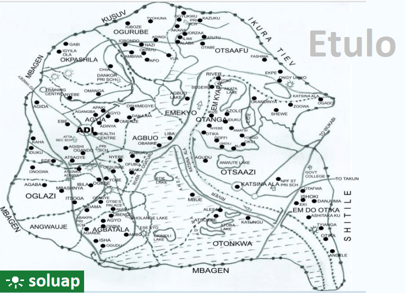
Etulo. Map of Etulo showing Adi, Okpashila, Ogurube and other parts
Map of Etulo showing Adi, Okpashila, Ogurube and other parts
Etulo (also known as Turumawa) is an ethnic group located on both sides of River Katsina Ala in Buruku and Katsina Ala local government areas of Benue state. Etulos were mostly fishermen but it has changed. Many are now into farming, office work, business among others occupations.
More
Adi, Etulo Adi is the capital of Etulo people. A rice, fish and palm wine trading hub in Etulo council ward of…
Adi: The Capital of Etulo People Adi is a vibrant and culturally rich town that serves as the capital of the Etulo people in Benue State,…
Map of Plateau State showing Local Government Areas Plateau Local Government Areas Barkin LadiBassaBokkosJos-EastJos-NorthJos-SouthKanamKankeLangtang NorthLangtang SouthManguMikangPankshinQua’an PanRiyomShendamWase
Map of Ebonyi showing Afikpo North Afikpo North Afikpo North Afikpo North is a Local Government Area of Ebonyi It’s headquarters and largest town is Afikpo…
Map of Adamawa showing the 21 LGAs Adamawa State map showing the 21 LGAs There are 21 Local Government Areas in Adamawa. Below are the names of…
Map of Benue State showing the 23 local government areas Benue State’s 23 local government areas AdoAgatuApaBurukuGbokoGumaGwer EastGwer WestKatsina-AlaKonshishaKwandeLogoMakurdiObiOgbadiboOhiminiOkpokwuOjuOtukpoTarkaUkumUshongoVandeikya
Map of Benue state showing Ado local government area Benue State’s 23 local government areasAdoAgatuApaBurukuGbokoGumaGwer EastGwer WestKatsina-AlaKonshishaKwandeLogoMakurdiObiOgbadiboOhiminiOkpokwuOjuOtukpoTarkaUkumUshongoVandeikya
Apa. Map of Benue state showing Apa local government area Benue State’s 23 local government areas:AdoAgatuApaBurukuGbokoGumaGwer EastGwer WestKatsina-AlaKonshishaKwandeLogoMakurdiObiOgbadiboOhiminiOkpokwuOjuOtukpoTarkaUkumUshongoVandeikya


 Region of Ethiopia showing administrative areas")


