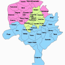
Kano State of Nigeria has Doguwa as it’s largest LGA (Local Government Area) by land area. It has a land area of 1,473 Km2. Doguwa is followed by:
- Sumaila: 1,250 Km2
- Tudun Wada: 1,204 Km2
- Kiru: 927 Km2
- Rogo: 802 Km2 and
- Dambatta: 732 Km2
Doguwa is located in the southern part of Kano State. It shares border with Tundun Wada LGA of Kano State in the North and Kaduna State to the West and Bauchi State to the East.


The population as of 2006 census was 151,181.
The headquarters of Doguwa is in Riruwai town.
Kano State comprises 44 LGAs:
The 44 LGAs of Kano State and are:
- Ajingi
- Albasu
- Bagwai
- Bebeji
- Bichi
- Bunkure
- Dala
- Dambatta
- Dawakin Kudu
- Dawakin Tofa
- Doguwa
- Fagge
- Gabasawa
- Garko
- Garun Mallam
- Gaya
- Gezawa
- Gwale
- Gwarzo
- Kabo
- Kano Municipal
- Karaye
- Kibiya
- Kiru
- Kumbotso
- Kunchi
- Kura
- Madobi
- Makoda
- Minjibir
- Nassarawa
- Rano
- Rimin Gado
- Rogo
- Shanono
- Sumaila
- Takai
- Tarauni
- Tofa
- Tsanyawa
- Tudun Wada
- Ungogo
- Warawa
- Wudil
Kano State has 44 Local Government Areas (LGAs), each administered by a council consisting of a chairman, who is the chief executive, councillors and other members.
Kano Local Governments, like other Local Governments in Nigeria are outlined in the Nigerian constitution. The functions are:
- Economic recommendations to the State Government.
- Collection of taxes and fees.
- Establishment and maintenance of cemeteries, burial grounds and homes for the destitute or infirm.
- Licensing of bicycles, trucks (other than mechanically propelled trucks), canoes, wheelbarrows and carts.
- Establishment, maintenance and regulation of markets, motor parks and public conveniences.
- Construction and maintenance of roads, streets, drainages and other public highways, parks, and open spaces.
- Naming of roads and streets and numbering of houses within their local government areas.
- Provision and maintenance of public transportation and refuse disposal systems.
- Registration of births, deaths and marriages in their locality.
- Assessment of privately owned houses or tenements for the purpose of levying such rates as may be prescribed by the House of Assembly of a State.
- Control and regulation of outdoor advertising, movement and keeping of pets of all descriptions, shops and kiosks, restaurants and other places for sale of food to the public, and laundries.
Kano State
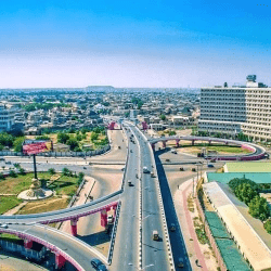
Kano State is located in the northwest geo-political zone of Nigeria. Hausa and Fulani, who are predominantly Muslims, inhabit the state. Yoruba, Igbo and other Nigerians also live in the state but mostly in the capital city also called Kano. 6 local government areas, namely; Fagge, Gwale, Tarauni, Kano Muncipal, Nassarawa and Dala have virtually merged into what is called Kano metropolis. The city of Kano is not only the capital but also the commercial nerve centre of the state.

Kano was among the 12 states created in May 1967 out of the former Northern Region. The state was intact until August 27,1991 when Jigawa State was carved out of it.
It is one of the largest states in Nigeria in terms of population, having a population of about 9, 383, 682 in the 2006 census. Its has 44 local governments, with an area of 20,479.6 square kilometer. The population density is about 458 persons per square kilometre.
The state has over 18, 684 square kilometres of cultivable land and it is the most extensively irrigated state in Nigeria. Kano State is noted for its famous markets and it is an industrial centre in the north. Trading articles in the Kano City include leather goods, local crafts, dyed textile materials as well as camels.


