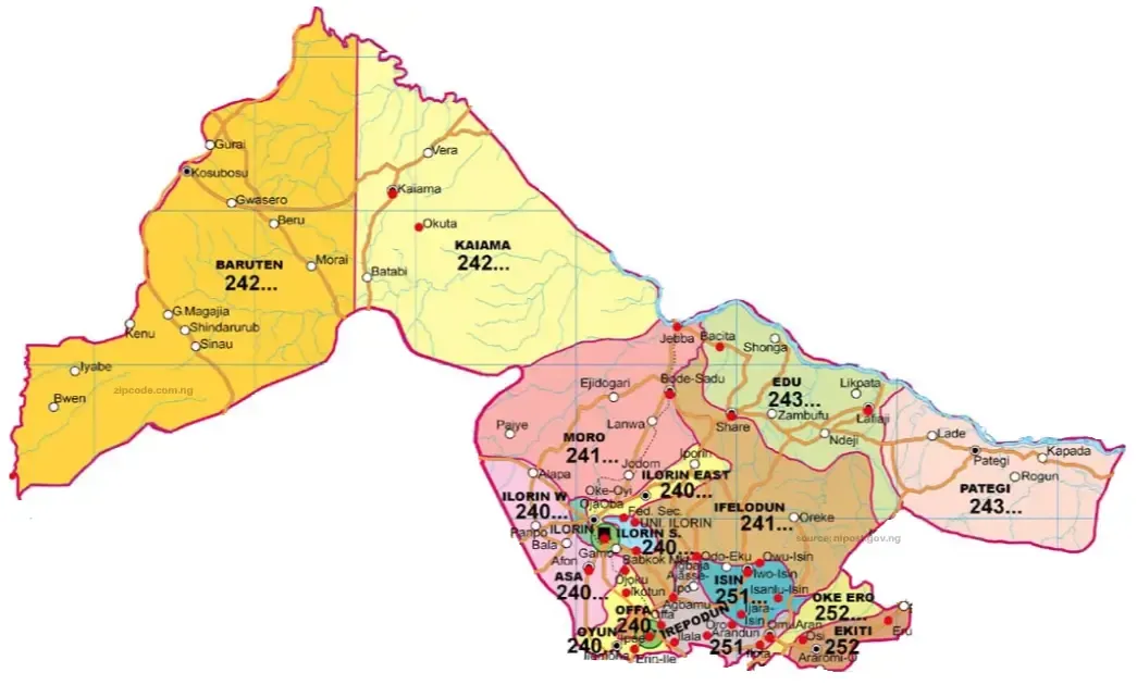
Asa Local Government Area
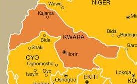
Asa local government area is located in Kwara state, North-central Nigeria and has the city of Afon as its headquarters. Asa LGA comprises several towns and villages which include Ogbondoroko, Afon, Laduba, Aboto, Balah, Eyenkonn, Pampo, Ogele, and Olowokere.
Asa local government area covers a total area of 1,286 square kilometers and a population of 126,435 as at the 2006 census. It features two distinct seasons which are the rainy and dry seasons. Asa LGA is known for the cultivation of a wide range of crops such as rice, corn, coconut and vegetables. Cloth weaving and dyeing are other key economic enterprises in the area.
Trade is also popular amongst dwellers of Asa LGA with markets such as the Alapa market and the Ogbondoroko main market attracting thousands of buyers and sellers of various commodities. Islam and Christianity are the widely practiced religions in Asa LGA while ethnic groups such as the Yoruba, Hausa, and Fulani are represented in the area. Asa LGA is home to a number of festivals such as the Awon festival and the Egungun festival. It’s major tourist attractions are the Shehu Alimi’s Mosque, the well at Kwo Alapa district, and the cattle dam and grazing reserve at lla-Oja.
Baruteen Local Government Area
Baruten is a Local Government Area in the North Central district of Kwara State, Nigeria, sharing a long border with the Republic of Benin. The local government begins in Ilesha Baruba and ends in Chikanda which is the border town, and it has its headquarters in the town of Kosubosu.
The main language of Baruten is Batonu. Other languages include Yoruba, French, Pidgin, Hausa, and Fulani. It has an area of 9,749 km² and a population of 209,459 as of the 2006 census. Its natural resources are maize, yam, melon, cotton, rice and guinea corn. It also has Maize, Guinea Corn, Yam, Melon, Cotton, Rice, and Yam-flour. It also has abundant granite deposits.
It is known for two major festivals, Gani and Dokoru. Chikanda, the border town, is also known for oil importation and exportation.
Edu Local Government Area
Edu local government was created in 1976 and had 6 districts until 1997 when a Local Government Area was carved out of it to reduce the districts to 3. The local government area shares boundaries with Ifelodun in the South, in the East with Pategi, North by River Niger and Niger State respectively.
This LGA has 10 wards. Its headquarters are in the town of Lafiagi. It has an area of 2,542 km² and a population of 201,469 as of the 2006 census. Its major languages are Nupe, Hausa and Yoruba. While the major towns are Lafiagi, Tsarogi, Tsonga, Bacita, Zambufu, Yikpata, Edogi, Puta, Gbugbu, Lema,
Kodokodo, Kpandaragi, Patidzuru, and Ogudu. It is abundantly blessed with rice, millet, sugarcane, melon, cassava, yam and guinea corn. Mineral resources such as Granite, Silica, Tantalite, Oolitic and Gypsum also occur in large deposits within the area.
It’s major festivals are Ndakogboya masquerade festival, Gugu -Eyagi masquerade festival and the Id el-Fitr and Id il-Kabir celebrations. Popular tourist attractions include the Monko Tauheed Tomb at Eson Tauheed near Lafiagi, Edozi Dukun, the Pottery Center near Lafiagi, the Pat-Ora Sacred Caveat, Tsaragi, Kpatako Spring Water near Tsonga, and the Tsoede Brinze Tada near Tsonga.
Ekiti Local Government Area
Ekiti local government was carved out of the old Irepodun local government area in October 1991. It shares boundaries with Ekiti State in the West and the headquarters is Araromi-Opin. The Local Government has 10 wards. It has an area of 480 km² and a population of 54,850 at the 2006 census. The two districts in the LGA are Osi and Obbo/Eruku.
The major towns are Osi, Obbo-IIe, Eruku, Araromi-Opin, Isapa, Isare-Opin, Isolo-Opin, Obbo, Aiyegunle, Ikerin-Opin, Ajuba, and Koro. Yoruba is the major language spoken in these towns.
Cassava, Yam, Kolanut, Lettuce and Orange are the predominant natural resources found in abundance within the LGA. While Granite also occurs in large deposits. Tourist attractions are the Oloroke Hill (Eruku), Wood Carving Center (Osi), Apo Olori (Isolo-Opin) and the Archaeological Site (Obbo).
Ifelodun Local Government Area
Ifelodun local government was created in 1976 out of the defunct Igbomina Ekiti Local Government Area. The Local Government Headquarters is Share and has 18 wards. The people of Ifelodun are Yorubas and mostly of Igbomina origin with roots in Ife, Oyo and Ketu. Much of the Ifelodun domain was overtaken by the Afonja/Alimi era and annexed to the present Ilorin enclave.
It has an area of 3,435 km² and a population of 206,042 at the 2006 census. It includes at least 80 villages and towns. The major towns are Igbaja, Oke-Ode, Agunjin, Ile-Ire, Ora, Oro-Ago, Omupo, Share and Idofihan, Ganmo, Babanloma, Alabe, Owode-Ofaro, Elerinjare, Idera. Yoruba and Fulani are the two major languages spoken in these towns.
Farmers cultivate Maize, Millet, Guinea Corn, Sorghum and Palm Oil in abundance. While mineral resources such as Granite, LimeStone, Marble, Dolomite, Quarts and Kaolin occur in large deposits.
The major festivals are Egungun, Epa, Sango, Alagbe dances. Tourists can also visit the Owu Falls (Owa Kajola) and Oke Agbonna Hills (Share).
Ilorin East Local Government Area
Ilorin East local government was created in 1991 from Ilorin Local Government with the Headquarters at Oke-Oyi. The Local Government has 11 wards. Its headquarters are in the town of Oke Oyi. It has an area of 486 km² and a population of 204,310 at the 2006 census.
The major towns are Iponrin, Apado, Oke-Oyi, Panada-Agbeyangi, IIe-Apa, Lajiki, Elesin-Meta, and Eudo Are. The major languages spoken are Yoruba, Hausa and Fulani. Ilorin East is also popular for its Maize, Cereal, Locust Beans and Cassava farmers. The LGA also has huge deposits of Granite, Clay and Kaolin. Its major festival is the Yawo Dancers festival. Tourists can visit the Sobi Hills, Pottery or Okuta Iponrin.
Ilorin West Local Government Area
Ilorin West local government was created in 1991 from the old Ilorin Local Government Area with Headquarters at Oja-Oba. The Local Government area has four districts 4 wards. It has an area of 105 km² and a population of 364,666 at the 2006 census. The major towns are Egbejila, Warrah Osin, Aremu, Ogidi, Oloje, Bani, and Adewole. Yoruba, Hausa and Fulani are the major languages spoken within the LGA.
Natural Resources such as Maize, Yam, Beans, Vegetables and Cassava grow in abundance in Ilorin South. While there are naturally occurring large mineral deposits of Granite, Clay and Kaolin.
The major festival in Ilorin South is the Yawo Dancers festival. Tourist attractions include the Old Alfa Alimi Mosque, Old Central Mosque, Oloje Poultry, Knitting of Cloth, Okuta Ilorin, Major Crutchley’s Grave,and the Emir Turbaning Mosque.
Irepodun Local Government Area
Irepodun local government was created out of the defunct Igbomina Ekiti Local Government Area in 1976 with Headquarters at Omu-Aran. The Local Government area has 10 wards. It has an area of 737 km² and a population of 148,610 at the 2006 census. It has very significant Yoruba cultural and historical significance. And is populated by the Igbomina people.
The major towns are Omu-Aran, Arandun, Oro, Esie, Ijan, Ajase-Ipo, Oko, IIudun, Agbamu, Sanmora, Aran-Orin, Oke Iya Ipo, IIala, Omido, Igbooluore, and Ijan. Yoruba is the predominant language spoken here. Irepodun is famous for its yams and grains. It also has large mineral deposits of Granite, Talc, Columbite, Tantalite, Turnstone, Feldspar, Quartz and Mica. The major festivals are Egungun, Ogun and Sango.
Tourists can visit the Esie Museum. The museum was the first to be established in Nigeria when it opened in 1945. The museum once housed over one thousand tombstone figures or images representing human beings. It is reputed to have the largest collection of soapstone images in the world. In modern times the Esie museum has been the center of religious activities and hosts a festival in the month of April every year.
Isin Local Government Area
Isin local government was created from the old Irepodun Local Government Area in 1996 with Headquarters at Owu-Isin. The Local Government area has 11 wards. It has an area of 633 km² and a population of 59,738 at the 2006 census. Its’ major towns are Isanlu-Isin, Ijara-Isin, Edidi, Oke-Onigbin, Iwo, Owu, Olla, Alla, Oke Aba, Odo Eku, Opanda, Kudu, and Oke-Oyi.
Yoruba is the predominant language in the area. Farmers of Isin cultivate Cocoa, Plantain, Yam, Maize and Corn during the rainy season. And there are large mineral deposits of Granite, Clay, Kaolin, Talc, Quartzite, Tomalin, Mia, Tantalite, Precious Stones, Feldspar and Marble.
The major festivals in Isin are Agbasin (Isanlu-Isin), Egungun. The major tourist attractions in Isin are the Ijoko Falls, Aise Falls, Atti Falls (Isanlu-Isin), Tii Oye Stone Images, Alaguso Mountain (Ijara Isin), Agabsin Shrine (Isanlu-Isin), Kooyi Shrine (Olla), and the Alawoji Forest (Iwo).
Kaiama Local Government Area
Kaiama local government was created in 1984. Its headquarters is located at Kaiama. It shares a boundary with Oyo State in the South, and Niger State in the North. It has 10 wards. It has an area of 6,971 km² and a population of 124,164 at the 2006 census. Its’ major towns are Kaiama, Banni, Kemanji, Kanikoro, Adena, Aboki, Woro, and Kugiji. Bokobaru, Hausa, Baruba and Fulani are the predominant languages in these towns.
Farmers cultivate Yam, Corn, Shea-nut, Livestock, Rice, Cotton, Millet and Timber. While Granite, Marble and Dolomite occur in large deposits. Its major festivals are Gani, Zonkon Masquerade, and the Takan Dancers. Tourist attractions include the Kanji Lake and the National Park.
Moro Local Government Area
Moro local government was created out of the Ilorin Native Authority in 1976. It shares boundaries with Oyo and Niger State respectively. The headquarters is located at Bode-Saadu. The local government has 17 wards. It has an area of 3,272 km² and a population of 108,792 at the 2006 census. Its’ major towns are Bode-Saadu, Ipaiye, Lanwa, Ejidongari, Olooru, Malete, Jebba, Arobadi, and Elemere.
The predominant languages are Yoruba, Hausa and Fulani. Moro is famed for its Yam, Corn, Cassava, Groundnut and Rice farms. It also has large deposits of mineral resources such as Granite, Talc, Dolomite, Tin, Stone, Marble, Dolomite, and Silica sand.
The major festivals are the Aaron Festival (Shao), and the Alagbe Acrobatic Dancers. Tourists can visit the Wreckage of Mungo Park, River Niger, Jebba Bronze Figures, Ogunjokoro, Jebba Bridge, and the Jebba Bronze figures.
Oke-Ero Local Government Area
Oke-Ero local government was created from Ekiti Local Government Area in 1996 with headquarters at IIoffa. The local government area has 10 wards. Oke-Ero has an area of 438 km² and a population of 57,619 at the 2006 census. The major towns of Oke-Ero are IIoffa, Odo-Owa, Ayedun, Idofin and Ekan. Yoruba is the predominant language spoken at the LGA.
The vegetation is tropical, hence the local economy is a hub for cash crops. The main industry of the people is in the area of agriculture as her citizens are mainly farmers. With her tropical climate, cocoa, maize, cassava, yam, sugar cane, bananas, oranges, cotton and jute (a soft, shiny vegetable fiber that can be spun into coarse, strong threads), are common cash crops. The oil palm is a tropical palm tree, and the fruit from it is used to make palm oil. Palm oil can be bought in all the Communities of the Local Government Area. You will also find large deposits of Granite and Feldspar.
Its major festival is the Egungun festival. Tourists can explore the Imole Boja, Rock Shelter, Odo-Owa, Ero-Omola Natural Falls, and Idofin Igbona.
Offa Local Government Area

Offa local government was created in 1991 with headquarters at Offa. The local government area has 10 wards. It has a population of 90,000 inhabitants at the 2006 census. The major towns are Adeleke, Igbewere, Igbadu, and Offa. Yoruba is the predominant language spoken at the Offa LGA.
Offa is well known for cultivation of Sweet potatoes and maize which also formed part of the favourite staple foods of the indigenes in the town. Offa in one of her eulogy is being addressed as the home of sweet potatoes. It also has large deposits of Granite. Cattle, goats and sheep are also raised in the environs. The key religions practiced in the town are:- Islam, Christianity and Traditional religions.
Its major festivals are Egungun, and Moremi festival. Tourist attractions include the Onimokas Shrine Offa and the Olofa of Offa’s palace.
Oyun Local Government Area
Oyun local government was created out of old Oyun-Offa Local Government Area in August 1991 with headquarters at IIemona. The local government area has 10 wards. It has an area of 476 km² and a population of 94,253 at the 2006 census.
Its major towns are Erin-IIe, Ira, Igosun, Ojoku, Igbona, Inaja, Ikotun, Ijagbo and Ipee. While Yoruba is the major language spoken at the Oyun LGA. Its climate supports crops such as Potatoes, Mangoes, Corn and Cassava. It also has large mineral deposits of Granite.
The House of Oya in Irra is a major tourist attraction. While Egungun and Onimoka festivals are the two major festivals in Oyun.
Patigi Local Government Area

Pategi local government was created from Edu Local Government Area with its headquarters in Pategi. The local government area has 10 wards. It has a population of 45,494 (22,712 males, 22,782 females) as of the 1991 census. It is inhabited by the Nupe people who also exhibit a linguistic repertoire of the Yoruba dialect.
They are farmers, aquatic sellers/fishers and traders. The major towns are Pategi, Lade, Kpada, Koro, Kusogi, Rogun, and Ariji. Nupe, Yoruba and Hausa are the predominant languages in Pategi. The Nupe people of Patigi are majorly farmers- harvesting cassava, millet, rice, guinea corn, melon.
They also make a lot of local snacks such as “efan”, “gbankuru”, “liala”, Kuli-kuli, “dankuwa” “banbara”, “alewa” etc. Mineral resources such as Granite, Clay, Columbite, Gold, Quartz, Iron, Ore, and Silica also occur in large quantities. The major festivals are the Pategi Regatta festival, and the Ndakogbaya Masquerade. Tourist attractions include the Etsu Nupe palace, Duku Irrigation Scheme, and Gwasun at Egwa Mama.
Reference
https://kwarastate.gov.ng/government/lgas/
