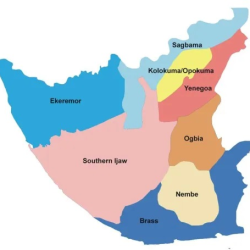
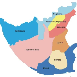
Bayelsa State consists of 8 Local Government Areas:
Brass
Ekeremor
Kolokuma/Opokuma
Nembe
Ogbia
Sagbama
Southern Ijaw
Yenagoa

Southern Ijaw is a Local Government Area of Bayelsa State, Southern part of Nigeria.
Its headquarters is in the town of Oporoma (or Osokoma) in the north.
Southern Ijaw is a Local Government Area is made up of several towns and villages which include Igbomotoro, Peremabiri, Opuama, Eniwari, Angiama, Diebu, Ondewari, and Aziama.
It has an area of 2,682 km2.
The area has a coastline of approximately 60 km on the Bight of Benin.
The people and their language are known as Izon.
The LGA also has a wide practice of religion such as Christianity and traditionalism.
It has institutions like the Niger Delta University(NDU), the state’s airport in Amassoma and Federal Polytechnic, Ekowe.
The first democratically elected governor, Chief Diepreye Alamieyeseigha (DSP) hailed from the area.
It is the home of Kolu United FC of Koluama II.

Ekeremor Local Government Area is located on the northwestern end of the State, with its western border forming part of the State’s coastline by the Atlantic Ocean.
Its northern border is marked by the Forcados River, one of the major distributaries of the Niger River. It is also drained by the Bomadi River.
It also comprises of Alabini, Opuokede Creek, Oporomor West and Aleibiri local Government Areas. It covers 21% of the total land area and holds 11.1% of the total population of the State.
The area is vastly blessed with natural resources and good soil for agriculture, as well as opportunities for tourism development.
The traditional occupation of the people include fishing, farming, trading, Raffia Palm tapping and distillation, lumbering and canoe carving, salt making, and hunting.

Brass Local Government Area is located on the southern part of the state by the Atlantic coast. Its southern border forms part of the State’s 203km coastline.
It also comprises of Akassa and Kaiko/Ibewo Local Government Areas, and covers 10% of total land area of Bayelsa, with 11.3% of the total population.
By virtue of its location by the Atlantic shoreline, its aquatic and terrestrial environment are mostly constituted by the sea (salt) and brackish water ecosystems, which provide natural abode and source for a variety of animal and plant species as well as other natural resources which influence the occupational mainstay of the people.
The traditional occupations of the people are mainly fishing, subsistence farming, trading and canoe carving.
However, the area is blessed with a variety of natural resources including fisheries, forest and mineral resources which hold great potential for viable investment.

Nembe local Government Area occupies the south eastern flank of the State.
Its southern border which forms part of the Bayelsa Coastline provides for the estuaries of the St, Nicholas, and Santa Babara Rivers emptying into the Atlantic Ocean.
It also comprises of Nembe East, Mini-Ikensi and Okoroma-Tekere local government areas.
It occupies 9.4% of the total land area, and holds 13.7% of the total population of Bayelsa.Nembe has numerous meandering creeks which are rich in fishery resources and a rich array of mangrove forest that are home to diverse plant and animal species.
The area is also blessed with cultivable land, food and cash crops as well as agro-based raw materials and natural minerals.
The traditional occupations of the people include fishing, trading, lumbering and wood sawing, canoe carving, weaving, and salt production.

Ogbia local Government area is located upland on the eastern flank of the state.
It also comprises Ogbia Central, Kolo Creek and Anyama local Government areas.
It occupies 6.4% of the total land area, with 14.2% of the total population of the State.
Although it still significantly drained by the Nun River and creeks like the Kolo Creek, and has large areas of wetlands, it has a considerably large cultivable land mass for large-scale farming.
The area is also endowed with rich forest resources and abundant reserve minerals, as well as great tourism potentials.
The traditional occupations of distillation, lumbering, hunting, canoe carving and weaving.

Kolokuma/Opokuma Local Government Area is one of the “up-land” local government areas, located on the northern part of the State, and drained by the Nun River.
It also comprises of Odi local government area, it occupies 7.8% of the total land area, and contains 6.0% of the total population of Bayelsa.
The area is blessed with agricultural, forest, and has potentials for tourism development.
The traditional occupations of the people include fishing, farming, lumbering and wood sawing, and local gin distillation.

Yenagoa is the capital of Bayelsa State.
The Yenagoa LGA has an area of 706 km² and a population of 266,008 at the 2006 census.
It is the home of the Bayelsa United FC, a premier league football club.
With credit to the restoration government, Yenagoa will soon be the home of the yet to complete Bayelsa State Cargo Airport.
Other noticeable infrastructure, Onopa Helipad, Amarata Diognostic Center and IPP Gbarain. Edepie – Rice Mill is strategically positioned for commercial Rice processing.
It will also house the proposed Eco-Industrial Park (EIP) at Gbarain, as given by the Restoration government of Dickson Seriake.

Sagbama local Government Area occupies the northern end of the State where the Niger River bifurcates into the Nun and Forcados Rivers.
It also comprises Mein-Oyiakiri, Tarakiri, and Toru-Abubou local government areas.
It covers 8.0% of the total land area, and holds 10.7% of the total population of Bayelsa.
The area has its rich share of cultivable land and agricultural, water, forest, and mineral resources.
The traditional occupations of the people include farming, fishing, lumbering, hunting, and carving.
